
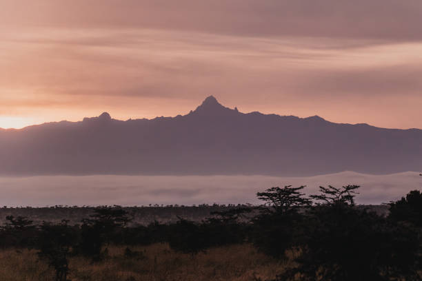
Mount Kenya, Africa’s second-highest peak, has a fascinating geological history shaped by volcanic activity, glacial carving, and ongoing erosion. Millions of years ago, it was a towering stratovolcano, standing up to 22,966 feet tall, but erosion has since reduced it to its current height of 17,057 feet. Today, climbers navigate its rugged volcanic core, exposed by glacial activity during the Ice Age and further sculpted by natural forces like freeze-thaw cycles and river erosion.
Key points about Mount Kenya’s formation and erosion:
- Volcanic Origins: Formed 3.1–2.6 million years ago, the mountain’s distinct rock types (like kenyte) influence climbing routes, offering varied grip and challenges.
- Glacial Shaping: Ice during the Pleistocene epoch carved U-shaped valleys, sharp ridges, and cirques, leaving striking features like the Lewis Glacier and tarns.
- Modern Erosion: Processes like river cutting, freeze-thaw cycles, and human activity continue to reshape trails and climbing conditions.
- Glacier Retreat: Mount Kenya’s glaciers are shrinking by 1–2 meters annually, exposing unstable rock and altering climbing routes.
Climbers face evolving challenges due to these changes, such as unstable scree, rockfall, and shifting trails. Proper preparation, route planning, and guidance from experienced locals are essential for safe ascents while minimizing environmental impact.
The Formerly 23,000 Foot Tall Volcano; Mount Kenya
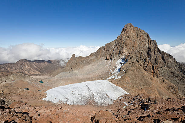
Ice Age Carving of Mount Kenya
Mount Kenya owes its dramatic alpine landscape not just to volcanic activity but also to the sculpting power of ice. During the Pleistocene epoch, glaciers transformed the mountain’s smooth volcanic slopes into jagged peaks, deep valleys, and sharp ridges – the same features that challenge climbers today.
How Ice Shaped the Mountain
Over hundreds of thousands of years, Pleistocene glaciers eroded nearly 2 km of summit material, exposing the solid volcanic core that now defines Mount Kenya. This relentless glacial activity carved out the U-shaped valleys that climbers encounter on routes like Sirimon and Chogoria.
Key glacial features continue to influence climbing routes:
- Cirques and tarns: Bowl-shaped depressions created by ice, such as the one housing Lewis Glacier, are scattered across the mountain. Alpine tarns, or small mountain lakes, add to the striking scenery in these upper reaches.
- Moraines: As glaciers retreated, they left behind rocky debris along their edges. These lateral moraines, especially along the Sirimon route, now serve as elevated paths that guides use to avoid muddy terrain.
- Rock striations: Scratches left by glacial movement are still visible on many exposed rock faces, revealing the direction of ancient ice flows.
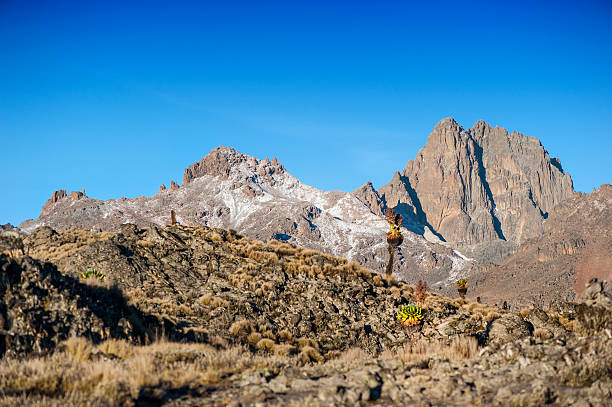
- Arêtes: Sharp ridges, like the one between Batian and Nelion, formed as glaciers carved away from opposing sides. Climbers following the Normal Route on Batian traverse one of these knife-edged ridges.
These glacial imprints not only define the mountain’s terrain but also shape the climbing experience, even as the glaciers themselves continue to retreat.
Current Glacier Loss
Today, Mount Kenya’s glaciers are shrinking rather than advancing, reshaping the mountain in new ways. From an estimated 18 glaciers in the early 1900s, only 11 remain, and they are retreating at a rate of about 1–2 meters (3.3–6.6 feet) annually.
Lewis Glacier, the largest of the remaining ice masses, has dramatically receded. In 1934, it extended much farther down the mountain’s northeastern face. Now, climbers must ascend significantly higher to reach its edge, as previously ice-covered rock becomes exposed.
This retreat brings new challenges for climbers:
- Unreliable ice routes: Many routes that relied on stable ice no longer form consistently, requiring guides to adjust their plans.
- Increased rockfall: As glaciers retreat, previously frozen rock faces become unstable, leading to more frequent rockfalls. Climbers on routes like the north face of Batian have reported loose, fractured rock in areas once covered by ice.
- Erosion and water flow changes: Meltwater patterns are shifting, altering streams and creating new erosion channels that can destabilize established trails.
The ongoing glacier retreat highlights the dynamic nature of Mount Kenya’s environment, where climbers must adapt to evolving conditions.
Mapping Ice Age Effects
Understanding how glaciers shaped Mount Kenya helps climbers navigate its terrain and anticipate potential challenges. The Sirimon route, for instance, features a classic U-shaped glacial valley with a relatively gentle grade in its lower sections. Around 13,123 feet (4,000 meters), visible striations on exposed rock reveal the direction of ancient ice flows, offering clues to stable resting points along the ascent.
The Chogoria route, on the other hand, showcases stunning glacial tarns like Lake Michaelson, nestled in cirques surrounded by steep headwalls. These natural amphitheaters, carved by ice, now serve as breathtaking camping spots.
Moraine deposits along major routes offer both benefits and hazards. Lateral moraines create well-drained ridges ideal for campsites, but their loose rock demands careful footing, especially during descents when fatigue can increase the risk of slips.
Climbers can also observe active glacial processes near the remaining ice masses. Below Lewis Glacier, fresh moraine deposits mark the glacier’s recent positions, creating unstable zones prone to rockfalls. Meanwhile, the periglacial zone – areas affected by freeze–thaw cycles but not covered by permanent ice – extends far below the glaciers. Here, daily temperature fluctuations produce scree fields, adding to the challenges of navigating Mount Kenya’s upper slopes.
The mountain’s evolving landscape, shaped by both ancient and modern glaciation, continues to test climbers while offering invaluable insights into its geological history.
Current Erosion Processes
Mount Kenya continues to evolve under the influence of natural forces and human activity. While volcanic and glacial erosion shaped the mountain’s dramatic landscapes in the past, modern processes like river erosion, freeze-thaw cycles, and foot traffic are actively reshaping its terrain. These changes bring new challenges for climbers, especially as trails and landmarks shift over time.
River Erosion and Valley Formation
The river systems of Mount Kenya play a key role in sculpting the mountain’s lower and middle elevations. The Tana River and its tributaries carve narrow, V-shaped valleys that contrast with the broad U-shaped valleys left behind by ancient glaciers. Over time, these rivers deepen their channels and widen their banks, continually altering the landscape.
One notable example is the Sirimon route, where volcanic deposits intersect with active river channels. The Sirimon River frequently changes the trail’s layout, especially during Kenya’s rainy seasons, which run from March to May and October to December. Heavy rains can wash away sections of the trail, create new stream crossings, or shift riverbeds overnight, forcing climbers to adapt their routes.
Higher up the mountain, streams cut through solid rock, forming dramatic gorges and ravines. These natural features not only serve as landmarks for experienced guides but also create significant obstacles for climbers carrying heavy gear. Seasonal flooding along routes like Naro Moru can further complicate matters, swelling rivers during storms and undermining traditional camping spots. In response, planners often relocate campsites to higher, more stable areas.
Freeze-Thaw Cycles and Scree
Above 13,000 feet (3,962 meters), Mount Kenya experiences daily freeze-thaw cycles that break down rock. Nighttime temperatures drop to around 32°F (0°C), while daytime highs reach approximately 50°F (10°C). This constant freezing and thawing causes water trapped in rock crevices to expand and contract, gradually breaking the rock apart and creating fields of loose scree.
These scree fields pose a challenge for climbers, especially in the early morning when thawing accelerates rockfall. The type of rock also plays a role: phonolite tends to break into angular fragments that provide better traction, while basalt weathers into rounded, unstable pieces. After heavy rainfall, rockfall incidents often increase due to the enhanced freeze-thaw activity.
Interestingly, during dry seasons, clear night skies can extend the freeze-thaw zone to lower elevations, making typically stable routes more hazardous. Guides frequently observe new debris along popular paths, especially during peak climbing periods, underscoring the mountain’s ever-changing nature.
Human Effects on Erosion
Human activity amplifies the natural erosion processes on Mount Kenya. Popular trails like Sirimon and Chogoria are widened and degraded by heavy foot traffic, as hikers often veer off established paths to avoid muddy or rocky sections. On steep switchbacks, repeated footsteps erode loose soil, further destabilizing the trails.
Local guides and porters work to mitigate these effects by sticking to natural contours and using moraine ridges to bypass fragile areas. However, campsites also face challenges. Locations like Mackinder’s Camp suffer from soil compaction and vegetation loss due to heavy use. Tent placement, cooking, and foot traffic harden the ground, increasing runoff during rains and contributing to downstream erosion.
Efforts to combat these issues include trail maintenance by the Kenya Wildlife Service and local guide associations. They focus on improving drainage and reinforcing vulnerable sections with stone steps, though the harsh conditions mean these fixes require regular upkeep.
Despite the challenges, local guides excel at adapting to the mountain’s shifting conditions. By carefully monitoring weather patterns, erosion cycles, and trail conditions, they help climbers navigate safely while minimizing environmental impact. Their expertise ensures that Mount Kenya remains accessible to adventurers while preserving its natural beauty.
How Erosion Affects Climbing Routes
Erosion on Mount Kenya creates unique challenges for climbers, demanding specialized gear and strategies tailored to specific routes. Understanding these hazards is essential for planning, ensuring safety, and making informed decisions about equipment and timing.
Route-Specific Erosion Challenges
Each route on Mount Kenya presents its own set of erosion-related obstacles, shaped by the mountain’s geology and weather patterns.
On the Sirimon route, scree instability is a frequent issue, especially in the higher heather zones. Overnight frost can loosen volcanic debris, making footing unpredictable in the early morning. The mix of phonolite and basalt fragments adds to the trail’s inconsistency, requiring extra care.
The Naro Moru route faces challenges from seasonal flooding, which can erode natural supports and expose slick rock surfaces hidden beneath vegetation. During rainy seasons, previously dry sections may transform into stream crossings, forcing climbers to navigate waterlogged and shifting terrain.
The Chogoria route is particularly prone to rockfall after heavy rains. The eastern face, exposed to strong winds, experiences freeze–thaw cycles that loosen rocks, funneling them into natural channels. Climbers often encounter falling debris, especially when temperatures hover near freezing.
Technical climbing routes on Batian and Nelion have also been reshaped by erosion. As glaciers retreat, they expose rock that was once covered by ice, turning straightforward climbs into more demanding ones. Loose moraine and unstable sections now require climbers to adjust their strategies and carry additional protective gear.
These evolving conditions demand not only refined techniques but also the right equipment to navigate safely.
Gear and Techniques for Erosion Hazards
To address the risks posed by erosion, climbers must equip themselves with the proper gear and adopt safety practices suited to the specific challenges of each route. Here’s a breakdown of key recommendations:
| Erosion Hazard | Recommended Gear | Safety Technique | Route Application |
|---|---|---|---|
| Scree instability | Microspikes, gaiters, trekking poles | Take short, deliberate steps; test each foothold carefully | Higher sections of the Sirimon route |
| Rockfall zones | Helmet, lightweight approach shoes | Travel early in the day; stay close to rock faces | Chogoria approaches and technical routes |
| Unstable stream crossings | Waterproof boots, spare socks | Use trekking poles for balance; proceed cautiously | Naro Moru and Sirimon river sections |
| Ice/mixed terrain | Crampons, ice axe, harness | Practice emergency self-arrest; consider small rope teams | Technical routes on Batian and Nelion |
| Waterlogged or muddy areas | Waterproof gaiters, grip-sole boots | Sidestep through mud; use natural features like rocks or roots for stability | Waterlogged sections of Naro Moru |
Timing and route selection play a critical role in managing these hazards. Experienced climbers often avoid scree-prone areas during warmer parts of the day, when rockfall is more likely, and remain flexible by choosing alternative campsites if erosion has affected the usual spots.
On technical routes, rope techniques have become increasingly important. With erosion removing traditional handholds, climbers now carry extra protection for areas previously considered moderate. Even seemingly solid volcanic formations require inspection, as freeze–thaw cycles can weaken their stability.
Insights From Local Guides
Local guides provide invaluable expertise in navigating Mount Kenya’s erosion-related challenges. Their firsthand knowledge of the mountain’s shifting landscape helps climbers adapt to changing conditions.
James Mwangi, a guide with over 15 years of experience on Mount Kenya, shared an observation from a recent Batian ascent:
kenyte veins now provide the most reliable holds where erosion has removed softer rock.
His insight highlights how geological changes are reshaping climbing strategies.
Porters, too, play a crucial role in managing these challenges. They often rely on ancient moraine ridges – formed by glacial deposits – for safer footing on unstable slopes. To assist climbers, porters sometimes place temporary stone markers to warn of new hazards, though these must be updated regularly as conditions evolve.
Partnering with experienced operators like Wild Springs Adventures ensures climbers receive the latest guidance on safe route selection. This real-time information helps mitigate risks, making climbs on Mount Kenya safer and more enjoyable despite the challenges posed by erosion.
Conservation and Future Changes
Mount Kenya, with its dramatic volcanic landscape, is constantly shaped by natural forces like erosion. However, human activity and environmental shifts are now adding new layers of pressure. The mountain attracts over 30,000 visitors every year, creating a delicate balance between preserving its fragile ecosystem and ensuring safe access for climbers and trekkers.
Managing Tourism Impact
Tourism, while an important source of revenue, can take a toll on Mount Kenya’s environment. Careless practices, such as overuse of climbing routes and littering, harm the mountain’s trails and biodiversity. A promising solution lies in community-based tourism. By offering experiences like cultural village stays and nature walks guided by Kikuyu communities, visitors can enjoy the mountain responsibly while contributing to the well-being of local people. Still, tourism isn’t the only challenge Mount Kenya faces – climate change is reshaping its future in significant ways.
Climate Change Projections
The effects of climate change are starkly visible on Mount Kenya. Scientific studies suggest that its glaciers may disappear entirely by 2050, with current rates of retreat estimated at 1–2 meters per year. This not only alters climbing routes, such as those along Sirimon, but also threatens the mountain’s critical role as a water source for millions of people in central Kenya.
Responsible Climbing Practices
Climbers have a unique opportunity to help protect Mount Kenya through thoughtful actions. Learning about local environmental and cultural issues is a great first step. Eco-friendly hiking practices, such as proper waste management and careful route selection, can significantly reduce environmental harm. It’s also essential to respect the cultural significance of the mountain. For the Kikuyu people, Mount Kenya is sacred, and climbers should always seek permission before photographing culturally important sites.
Choosing eco-certified accommodations and working with experienced local operators, such as Go To Mount Kenya, ensures that tourism benefits nearby communities while minimizing its ecological impact. These practices not only support conservation efforts but also enhance the experience for future climbers.
The challenge lies in striking a balance between accessibility and preservation. By adopting responsible practices, we can safeguard Mount Kenya’s unique geological features and cultural heritage for generations to come.
Conclusion: Understanding Mount Kenya’s Geology
Mount Kenya’s 3.1-million-year journey, from fiery volcanic origins to ice-sculpted peaks, is etched into every climber’s experience. Whether you’re navigating the loose scree of the Sirimon route or gripping kenyte holds on Batian’s North Face, you’re interacting with a landscape shaped by millennia of geological change.
This ever-changing environment, marked by retreating glaciers and increasing rockfall, demands awareness and preparation. Glaciers are shrinking by 1–2 meters annually, while heavy rains raise rockfall risks by 15%. Decades of weathering strip away 1–2 cm of rock, exposing new challenges for climbers and creating the loose scree that tests balance and footing. These dynamic processes shape every ascent, making geological understanding a crucial part of safe climbing.
Local guides, with experience from over 100 treks, bring invaluable knowledge to the table. Their ability to interpret the mountain’s geological features – like glacial striations or unstable scree slopes – turns potential hazards into manageable obstacles, ensuring safer and more informed climbs.
These geological insights also guide smarter route choices. With trail erosion averaging 10 cm per year and the possibility of an ice-free Mount Kenya by 2050, climbers must tread thoughtfully. Using the right gear, sticking to designated trails, and heeding expert advice not only reduces risks but also helps preserve the mountain’s fragile geological heritage.
Every ridge and rock on Mount Kenya tells a story of ancient eruptions and relentless erosion. Climbing here requires respect, preparation, and a willingness to learn from the landscape. By understanding these processes, climbers can responsibly become part of Mount Kenya’s ongoing story.
Partnering with experienced operators like Wild Springs Adventures ensures climbers gain valuable geological insights while contributing to conservation efforts that protect this UNESCO World Heritage site. The mountain’s story evolves with every season, and by embracing geological awareness, climbers can play a role in preserving its legacy for generations to come.
FAQs
How does the shrinking of Mount Kenya’s glaciers affect climbing routes and safety for climbers?
Mount Kenya’s glaciers have receded dramatically – losing over 95% of their mass since 1900 – and this has transformed climbing conditions on the mountain. The shrinking ice has left behind unstable rock, loose scree, and an increased risk of rockfall, especially during or after heavy rains. These hazards are particularly evident on technical routes like Batian and Nelion, where the exposed terrain now requires extra vigilance and skill.
For a safer climb, it’s crucial to bring essential gear such as crampons and microspikes to improve traction and stability on slippery or uneven surfaces. Equally important is understanding how the landscape has changed and being prepared for the unpredictable conditions that come with tackling Mount Kenya’s demanding routes.
What geological features of Mount Kenya shape the climbing experience, and how did they form?
Mount Kenya offers a climbing experience deeply influenced by its volcanic history and the lasting effects of glacial erosion. About 3 million years ago, volcanic activity formed the mountain’s iconic peaks, like Batian and Nelion. These peaks are made up of solid volcanic rock, providing climbers with dependable handholds and footholds.
Over the millennia, Pleistocene glaciers sculpted the mountain, carving out U-shaped valleys, cirques, and moraines. This glacial activity is responsible for the rugged, dramatic terrain that climbers encounter today.
These geological characteristics don’t just shape the mountain’s beauty – they also add to the technical challenges of climbing. As glaciers have receded, they’ve left behind steeper rock faces, while erosion continues to affect trail conditions. This makes careful planning and preparation a must for anyone aiming to conquer Mount Kenya.
How can climbers reduce their environmental impact while hiking Mount Kenya’s erosion-affected trails?
Climbers heading to Mount Kenya can help protect its delicate ecosystem by adhering to Leave No Trace principles. This includes sticking to marked trails, carrying out all trash, and being mindful not to harm the vegetation. Using the right equipment, like microspikes, is also key – it helps reduce trail erosion, particularly on loose scree or icy paths.
Trekkers can also contribute by choosing ethical tour operators who prioritize conservation and following established guidelines aimed at safeguarding the mountain’s environment. Simple measures, such as keeping campsites undisturbed and avoiding shortcuts, play a crucial role in ensuring Mount Kenya remains pristine for generations to come.