Mount Kenya Lakes and Tarns – The Complete 2026 Guide
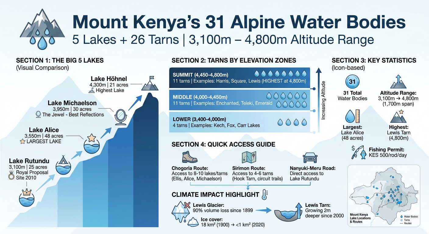
Mount Kenya is home to 31 alpine water bodies, including 5 lakes and 26 tarns, ranging from 3,100m to 4,800m in altitude. Collectively, these lakes and tarns, shaped by glacial activity, offer stunning landscapes, fishing opportunities, and historical significance. Highlights include:
- Lake Rutundu (3,100m): Famous for Prince William’s 2010 proposal; stocked with trout.
- Lake Alice (3,550m): The largest lake, named after Princess Alice.
- Lake Michaelson (3,950m): Known for its dramatic amphitheater setting and reflections of Mount Kenya’s peaks.
- Lewis Tarn (4,800m): The highest water body, growing as glaciers retreat.
Notably, Fishing requires a Kenya Wildlife Service permit (KES 500 per rod/day). Visit during early mornings or late afternoons for the best experience. Photographers can capture breathtaking reflections, glacier retreat, and vibrant wildlife near these lakes. A 7-day trek via the Chogoria route offers access to many of these stunning sites. Mount Kenya’s lakes and tarns are a testament to the mountain’s geological history and natural beauty.
Mount Kenya’s 31 Lakes and Tarns: Altitude, Size, and Access Guide
THE MOST EPIC MT. KENYA HIKE |VLOG| Lake Ellis + Lake Michaelson
The Five Named Lakes of Mount Kenya
Mount Kenya is home to five named lakes, each sitting between 3,100 and 4,300 meters in elevation. These lakes, ranging from 21 to 48 acres in size, are rich in history, tied to early explorers and British royalty. Beyond their historical significance, they also serve as popular spots for trout fishing, offering unique experiences for visitors exploring the mountain’s slopes.
Lake Rutundu – 3,100m · 25 Acres
Lake Rutundu became widely known after a royal proposal took place there in November 2010. On its shore, the Rutundu Log Cabin preserves a guest book entry from Prince William, written the morning after the proposal. The lake was stocked with trout in the early 1930s by Raymond Hook and Humphrey Slade.
To get there, visitors can reach this serene lake by taking the Kisima turnoff on the Nanyuki-Meru road. At 3,100 meters, it is a haven for rainbow and brown trout enthusiasts.
Lake Alice – 3,550m · 48 Acres – The Largest
Spanning 48 acres, Lake Alice is the largest of Mount Kenya’s lakes. It was named after Princess Alice, Duchess of Gloucester, who visited the mountain in 1934 and ascended to around 4,300 meters.
Today, nestled in a crater near the Ithangune satellite cone, this lake lies at 3,550 meters within a glacial basin. Its remote location makes it a less-frequented spot, though its waters teem with trout.
Lake Ellis – 3,500m · 28 Acres
Lake Ellis serves as the Day 1 campsite for climbers taking the Chogoria route. It was named after Thomas Evelyn Scott-Ellis, who reached the lake during his 1927 expedition. Covering 28 acres, this lake sits at 3,500 meters and is surrounded by heather and groundsel.
In addition, nearby Mugi Hill offers a stunning vantage point, overlooking the lake and its valley. Rainbow and brown trout thrive in its waters, adding to its charm for climbers and anglers alike.
Lake Michaelson – 3,950m · 30 Acres – The Jewel
Lake Michaelson, often referred to as a jewel, is located in a glacial amphitheater within the Gorges Valley at 3,950 meters. Sir Halford Mackinder named the lake after a friend during his 1899 expedition to summit Batian. Above it, a striking 300-meter cliff known as The Temple rises above its western shore.
Meanwhile, Vivienne Falls cascades into the lake, and on calm mornings before 9:00 AM, the water reflects the peaks of Batian (5,199m) and Nelion (5,188m). For travellers who want to visit this lake specifically without a full summit attempt, our Lake Michaelson Explore day expedition offers a focused trek into the Gorges Valley. This makes it a favorite destination for photographers and climbers.
Lake Höhnel – 4,300 m · 21 Acres
Lake Höhnel, located at 4,300 meters in the Höhnel Valley near Castlehill, is named after Lieutenant Ludwig von Höhnel. He served as second-in-command during Count Samuel Teleki’s 1887 expedition.
Despite its remote setting, this high-altitude lake, carved into a rock basin by glacial erosion, hosts trout in its waters. However, accessing the lake via the Chogoria route is no easy task, adding an extra layer of adventure for those who visit.
These five lakes, with their rich history and breathtaking landscapes, highlight the blend of natural beauty and human legacy found on Mount Kenya. They serve as a gateway to the alpine tarns that await further up the slopes.
Mount Kenya’s Alpine Tarns – 26 Named High-Altitude Water Bodies
Mount Kenya is home to 26 smaller alpine tarns scattered across its upper slopes, in addition to its five major lakes. These tarns, formed by glacial activity in cirques and U-shaped valleys, span elevations from 3,400 meters at Kech Tarn to 4,800 meters at Lewis Tarn, the highest water body on the mountain.
Below, here’s a closer look at the tarns grouped by elevation: lower, middle, and summit.
Lower Tarns (3,400–4,000m)
Kech Tarn, sitting at 3,400 meters in Hinde Valley, is named after Richard Ketch, a Kenya Wildlife Service warden. It can be accessed via the Sirimon or Chogoria routes. Fox Tarn, located at 3,900 meters near Leopard Rock, is a feature along circuit trails.
At 4,000 meters in Hobley Valley, the Carr Lakes consist of two separate tarns named after Ernest Carr. These lower tarns provide a picturesque introduction to Mount Kenya’s high-altitude water bodies.
Middle Tarns (4,000–4,450m)
Eleven tarns are found between 4,000 and 4,450 meters, each with its own story. Enchanted Tarn, at 4,250 meters, lives up to its name with its serene beauty. For instance, at 4,300 meters, Teleki Tarn is named after Count Samuel Teleki, who was part of an 1887 expedition to the region.
Similarly, Hall’s Tarn, also at 4,300 meters, is located at Mintos Camp and commemorates the Fort Hall District Commissioner. Thompson Tarn, at 4,350 meters, honors the 1891 British East Africa expedition.
Further up, two tarns in Hausberg Valley – Hausberg Tarn and Oblong Tarn – rest at 4,370 meters and feed into the Nanyuki River. Hanging Tarn, perched at 4,430 meters and formerly called Gitchini, and Gallery Tarn at 4,450 meters, add to the mountain’s allure.
Emerald Tarn (4,450m) gets its name from the green hue created by glacial silt. Tyndall Tarn, also at 4,450 meters, lies below the retreating Tyndall Glacier. Nanyuki Tarn, at 4,470 meters, is a key waypoint on the Western Peak Circuit.
Summit Tarns (4,450–4,800m)
The summit tarns are clustered near Mount Kenya’s highest peaks, serving as landmarks for climbers.
Hut Tarn, also known as Two Tarn, is situated at 4,490 meters on Teleki Ridge. Polishman’s Tarn (4,440m), located at Hausberg Col, was named after a Polish artist who visited the area. Kami Tarn, at 4,400 meters near Batian, was once a base camp for North Face expeditions but is now shrinking.
Lower Simba Tarn (4,390m) and Upper Simba Tarn (4,600m) are named after a 1924 report of a lion sighting by porters. Square Tarn, at 4,700 meters below Point Lenana, is aptly named for its geometric shape.
Harris Tarn, at 4,750 meters, honors P. Wyn Harris, who, along with Eric Shipton, made the first ascent of Nelion in 1929. Reaching the summit tarns near Batian and Nelion requires technical climbing skills. Our 8-Day Nelion & Batian Technical Climb is the expert-guided route for climbers aiming at these routes. Finally, Lewis Tarn, at 4,800 meters below the retreating Lewis Glacier, is the highest tarn on Mount Kenya. Since 2000, it has deepened by 2 meters, while glaciologists report the glacier has retreated by 90% since 1899.
Complete Table – All 31 Mount Kenya Lakes and Tarns
This table provides a detailed overview of the Mount Kenya lakes and tarns system. It includes information on altitudes, sizes, access routes, GPS coordinates, and historical notes for all 31 water bodies.
| Named after the 1891 British East Africa expedition | Altitude (m) | Size (acres) | Route Access | GPS | Historical Note |
|---|---|---|---|---|---|
| Lake Rutundu | 3,100 | 25 | Kisima turnoff, Nanyuki-Meru road | -0.1167, 37.4833 | Prince William proposed to Kate in November 2010; named after Rutundu Hill |
| Lake Alice | 3,550 | 48 | Chogoria route via Ithangune Hill | -0.1500, 37.4500 | Largest lake; named after Princess Alice, Duchess of Gloucester |
| Lake Ellis | 3,500 | 28 | Chogoria route, Day 1 camp | -0.1400, 37.4600 | Named after Thomas Evelyn Scott-Ellis, first European to reach it (1927) |
| Lake Michaelson | 3,950 | 30 | Chogoria route via Gorges Valley | -0.1350, 37.4700 | Named by Halford Mackinder (1899); fed by Vivienne Falls; 300m Temple cliff |
| Lake Höhnel | 4,300 | 21 | Deep Chogoria via Höhnel Valley | -0.1250, 37.4650 | Named after Lt. Ludwig von Höhnel, 2nd-in-command of Teleki’s 1887 expedition |
| Kech Tarn | 3,400 | 3 | Hinde Valley | -0.1600, 37.4400 | Named after Richard Ketch, Kenya Wildlife Service warden |
| Fox Tarn | 3,900 | 2 | Circuit trails near Leopard Rock | -0.1450, 37.4550 | Named for proximity to Leopard Rock |
| Carr Lakes (Tarn 1) | 4,000 | 4 | Hobley Valley | -0.1380, 37.4620 | Named after Ernest Carr, founder of Mountain Club of East Africa |
| Carr Lakes (Tarn 2) | 4,000 | 4 | Hobley Valley | -0.1382, 37.4622 | Named after Ernest Carr, founder of Mountain Club of East Africa |
| Enchanted Tarn | 4,250 | 2 | Chogoria high route | -0.1320, 37.4680 | Named for serene setting |
| Teleki Tarn | 4,300 | 3 | Chogoria route | -0.1300, 37.4690 | Named after Count Samuel Teleki, leader of 1887 expedition |
| Halls Tarn | 4,300 | 2 | Mintos Camp | -0.1310, 37.4700 | Named after District Commissioner of Fort Hall (Murang’a) |
| Thompson Tarn | 4,350 | 2 | Chogoria high route | -0.1290, 37.4710 | Named after 1891 British East Africa expedition |
| Hausberg Tarn | 4,370 | 3 | Hausberg Valley | -0.1280, 37.4720 | Drains to Nanyuki River |
| Oblong Tarn | 4,370 | 2 | Hausberg Valley | -0.1275, 37.4725 | Named for elongated shape |
| Hanging Tarn | 4,430 | 2 | Chogoria route | -0.1260, 37.4730 | Formerly called Gitchini |
| Gallery Tarn | 4,450 | 2 | Summit circuit | -0.1250, 37.4740 | Named for gallery-like setting |
| Emerald Tarn | 4,450 | 2 | Summit circuit | -0.1245, 37.4745 | Named for green color from glacial silt |
| Tyndall Tarn | 4,450 | 3 | Below Tyndall Glacier | -0.1240, 37.4750 | Named after retreating Tyndall Glacier |
| Nanyuki Tarn | 4,470 | 2 | Western Peak Circuit | -0.1230, 37.4760 | Key waypoint on circuit route |
| Hut Tarn (Two Tarn) | 4,490 | 1 | Teleki Ridge | -0.1220, 37.4770 | Located near Austrian Hut site |
| Polishman’s Tarn | 4,440 | 1 | Hausberg Col | -0.1285, 37.4715 | Named after Polish artist who visited |
| Kami Tarn | 4,400 | 2 | Near Batian | -0.1270, 37.4735 | Former North Face base camp; shrinking rapidly |
| Lower Simba Tarn | 4,390 | 2 | Summit circuit | -0.1265, 37.4740 | Named after 1924 lion sighting report by porters |
| Upper Simba Tarn | 4,600 | 1 | Summit circuit | -0.1255, 37.4750 | Companion tarn to Lower Simba |
| Square Tarn | 4,700 | 1 | Below Point Lenana | -0.1235, 37.4765 | Named for geometric shape |
| Harris Tarn | 4,750 | 1 | Near Nelion | -0.1225, 37.4775 | Named for the green color of glacial silt |
| Lewis Tarn | 4,800 | 2 | Below Lewis Glacier | -0.1215, 37.4785 | Highest water body; below retreating Lewis Glacier, growing as ice melts |
| Hook Tarn | 4,100 | 2 | Sirimon route | -0.1420, 37.4580 | Popular fishing spot on Sirimon |
| Curling Pond | 4,550 | 1 | Summit circuit near Austrian Hut | -0.1248, 37.4755 | Named for ice formation patterns; seasonal |
| American Tarn | 4,380 | 1 | Hausberg Valley | -0.1278, 37.4718 | Named after American expedition members (1930s) |
The GPS coordinates are approximate and provided in decimal degrees (latitude, longitude). Tarn sizes are based on surveys conducted between 2024 and 2026, and these may shift as glaciers continue to retreat.
Fishing the Lakes of Mount Kenya
Best Fishing Lakes and Altitudes
Mount Kenya offers an incredible opportunity to fish for rainbow and brown trout in its stunning high-altitude lakes. Some of the best spots include Lake Rutundu (3,100m), Lake Alice (3,550m), Lake Ellis (3,500m), Lake Michaelson (3,950m), and Hook Tarn (4,100m) along the Sirimon route. Each lake presents its own unique challenges, making the experience both rewarding and diverse. Our 5-Day Mount Kenya Lakes Tour includes stops at Lake Ellis and Lake Michaelson with optional fishing time for permit holders.
KWS Fishing Permits and Park Fees
Before casting your line, you’ll need a Kenya Wildlife Service (KWS) permit. The cost is approximately KES 500 per lake per day per rod, plus park entry fees. Be mindful of the rules – fines for non-compliance can climb to KES 50,000. Permits are available at park gates or the KWS office in Nanyuki, so make sure to secure yours before starting your trek. These regulations are in place to promote sustainable fishing and protect the mountain’s delicate ecosystem.
When and Where to Cast Your Line
For the best results, fish during the early morning or late afternoon when trout are most active near the shorelines. Among the lakes, Lake Michaelson offers the highest-altitude fishing experience, while Lake Rutundu is more accessible, making it a favorite among anglers. If you’re trekking the Sirimon route, Hook Tarn provides a convenient spot for a quick fishing break.
Catch-and-Release Rules and Conservation
To preserve trout populations, practice catch-and-release fishing and respect no-kill zones near camps. Additionally, each angler should limit themselves to carrying just one rod. By following these guidelines, you’ll help ensure that Mount Kenya’s fishing remains a sustainable and enjoyable activity for years to come.
Photography at Mount Kenya’s Lakes
Mount Kenya’s lakes offer a stunning mix of natural beauty and an opportunity to document critical changes in the environment. Lake Michaelson, situated at 3,950 meters in the Gorges Valley, is a standout spot for photographers. Arriving early – by 6:00 AM – lets you capture the serene reflections of Batian (5,199m) and Nelion (5,188m) before the wind disturbs the surface, typically after 9:00 AM. The scene is framed by the dramatic 300-meter cliff of The Temple, with Vivienne Falls adding an extra layer of depth. For best results, use a wide-angle lens (16-35mm) with an aperture of f/8-11 and a low ISO to ensure sharp, detailed shots of this amphitheater-like setting. If photography is your main motivation, our dedicated Mount Kenya Photography & Nature Trek via the Burguret Route is built around dawn light at Michaelson and the northern valleys
Lewis Tarn: Documenting Glacier Retreat
By contrast, Lewis Tarn, located at 4,800 meters, offers a different kind of photographic opportunity. It highlights the stark reality of glacier retreat. The Lewis Glacier has been shrinking by about 20 meters per year since the 2000s. This melting ice has caused the tarn to grow, providing a visual testament to climate change. To capture the contrast between the bright glacier ice and the darker water, try using bracketed exposures. These images serve as a crucial record of a landscape that may be unrecognizable in the next two decades if the glacier continues to disappear.
Beyond the scenery, the lakes aren’t just about landscapes – they’re also teeming with vibrant wildlife. Over 30 species of sunbirds thrive around the giant lobelias near the lakes, including the striking Scarlet-tufted Malachite Sunbird. To photograph these fast-moving birds, position yourself about 5 meters from the lobelia stands during dawn or dusk when they’re most active. A telephoto lens of 400mm or more, paired with a shutter speed of 1/1000s, can freeze their motion against the alpine scenery.
Night Photography and Astro Shots Above 4,500m
Additionally, for those interested in night photography, the period from June to September offers the clearest skies and driest conditions. Full moon nights are perfect for star-trail compositions, especially over lakes like Square Tarn (4,700m) below Point Lenana. Be prepared for sub-zero temperatures at these altitudes by using insulated bags to protect your gear. Shooting in RAW format is essential to retain maximum detail and flexibility when editing high-contrast scenes, especially those involving glaciers and starlit skies.
The Geology – Why Mount Kenya Has So Many Lakes
Mount Kenya, a stratovolcano, formed over 2.5 to 3.5 million years through repeated eruptions of trachytic and phonolitic lava. These silica-rich eruptions created steep slopes and a complex ridge system. This is quite different from the gentler slopes of basaltic volcanoes. The trachytic rock is highly stable and resistant to erosion, allowing water-filled basins to endure for thousands of years. This volcanic structure laid the groundwork for the mountain’s numerous lakes and tarns.
Then, around 21,000 years ago, a massive eruption caused the caldera to collapse, forming an 8×12 km basin with natural depressions at varying elevations. This event set the stage for Mount Kenya’s remarkable collection of 31 water bodies, making it a standout feature in the region.
How Glaciers Carved U-Shaped Valleys
Later, during the Pleistocene ice ages, glaciers carved U-shaped valleys into the mountain through erosion, transforming volcanic basins into natural amphitheaters. These U-shaped valleys, like those in the Gorges and Höhnel areas, have flat bottoms and steep walls, which efficiently trap water. In contrast, V-shaped river valleys allow water to drain more easily. As a result, the U-shaped depressions are far better at retaining water, contributing to the mountain’s abundance of lakes.
Modern Glacier Retreat and New Tarns
Since then, the glaciers on Mount Kenya have retreated significantly since the late 19th century. For instance, Lewis Glacier has lost 90% of its volume, with the mountain’s total ice cover shrinking from 18 km² in 1900 to less than 1 km² by 2020. Tyndall Glacier, retreating at a rate of 8–10 meters per year, leaves behind exposed bedrock depressions that fill with meltwater, forming new tarns or expanding existing ones, such as Lewis Tarn at an elevation of 4,800 meters. These ongoing changes continue to shape the mountain’s water bodies.
Seismic Activity Beneath the Mountain
Adding to this dynamic environment, geodetic monitoring from 2004 to 2006 revealed over 100 seismic swarms, with magnitudes reaching up to 2.0. Ground uplift of 1–2 cm per year confirmed the presence of active magmatic systems beneath the mountain. This underground activity impacts groundwater movement and creates fractures in the volcanic rock, influencing how long lakes persist by either retaining or draining water. These processes highlight the ever-changing nature of Mount Kenya’s geological and hydrological landscape.
How to Visit All the Lakes – The 7-Day Expedition
Most climbers typically visit two lakes during a standard Point Lenana ascent. However, a 7-day expedition along the Chogoria route offers so much more. This journey takes you to Lake Ellis, Lake Alice, and Lake Michaelson, with a summit of Point Lenana (4,985m). Along the way, you’ll also cross Hall and Hausberg tarns before concluding near Lake Rutundu, where you can even try your hand at fishing.
Altogether, in total, this itinerary covers 12–15 tarns. However, if you’re aiming to visit all 31 water bodies, be prepared to dedicate extra time and bring technical gear. For an unforgettable high-altitude adventure, join our Mount Kenya Group Treks 2026–2027 with guaranteed Sirimon–Chogoria departures, or request a custom 5-Day Lakes & Summit itinerary.
FAQs
How many lakes and tarns are on Mount Kenya?
Mount Kenya is home to 31 water bodies, consisting of 5 lakes and 26 tarns. These are scattered across different altitudes and diverse landscapes, adding to the mountain’s natural beauty.
Where did Prince William propose to Kate in Kenya?
Prince William proposed to Kate at Lake Rutundu in Kenya in November 2010. This spot is cherished for its peaceful and scenic charm.
Can you fish at Lake Michaelson?
Yes, you can fish for rainbow and brown trout at Lake Michaelson. However, you’ll need a KWS permit to do so.
Here’s the modern, emoji-friendly markdown table — ready to paste directly into your WordPress block editor (use a “Table” block or just paste as markdown if your editor supports it):
🏔️ Plan Your Mount Kenya Adventure
| 🎯 What You’re Looking For | 🗺️ Recommended Option | 🔗 Link |
|---|---|---|
| 🥾 Classic lakes trek with summit option | 5-Day Mount Kenya Lakes Tour – Chogoria Route | Book this trek → |
| 🦁 Climb + safari combo in northern Kenya | Mount Kenya Chogoria Route Climb & Northern Kenya Safari | See itinerary → |
| ⛰️ Full traverse across the mountain | 5-Days Sirimon to Chogoria Mount Kenya Climb | View dates → |
| 📅 Fixed group departures with confirmed dates | Mount Kenya Group Treks 2026–2027 | Check availability → |
| 📷 Photography-focused trek | Lake Michaelson Explore | Discover more → |
| 🌍 Browse all options | All Mount Kenya & Mountain Tours | Explore tours → |
| 🥾 Other Kenya hikes | All Hiking Trips in Kenya | Browse hikes → |
📚 Keep Reading – Related Mount Kenya Guides
| 📖 Guide | 💡 What You’ll Learn |
|---|---|
| 🎒 Essential Gear Checklist for Mount Kenya Trekking | Exactly what to pack for altitude, cold, and rain |
| 📆 Mount Kenya Group Treks 2026–2027 | Fixed Dates & Prices | Confirmed departures and per-person pricing |
| 🥾 Rurimeria Peak Hiking Guide | Best training hike before tackling Mount Kenya |
FAQs
How many lakes and tarns are on Mount Kenya?
Mount Kenya is home to 31 alpine water bodies — 5 named lakes and 26 tarns — scattered between 3,100m and 4,800m in altitude. Each was shaped by glacial activity over millions of years.
Where did Prince William propose to Kate in Kenya? Prince William proposed to Kate Middleton at Lake Rutundu on Mount Kenya in November 2010. The Rutundu Log Cabin guest book still holds his entry from the morning after the proposal.
Can you fish at Lake Michaelson? Yes, you can fish for rainbow and brown trout at Lake Michaelson, but you'll need a Kenya Wildlife Service (KWS) permit costing approximately KES 500 per rod per day. Catch-and-release is encouraged.
What is the highest lake on Mount Kenya?
Lewis Tarn at 4,800 meters is the highest water body on Mount Kenya. Located below the retreating Lewis Glacier, it has grown by 2 meters in depth since 2000 as the glacier melts.