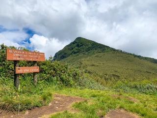
🐘 Elephant Hill — Njabini Route, Aberdare National Park, Kenya
Safari at a Glance
Wild Springs Adventures | 📍 Kinangop, Nyandarua County
🌿 Kenya's Most Popular Day Hike — and Its Most Misunderstood
Every weekend, groups of hikers load into minivans in Nairobi, excited about what many tour operators have billed as a "beginner-friendly day hike." By the time they are knee-deep in the bamboo zone, breathing thin air at 3,000 metres, drenched from an unexpected hailstorm, they understand the truth: Elephant Hill is not a beginner hike. It never was.
It is, however, the single best day hike accessible from Nairobi. Not in spite of the difficulty — because of it.
The hill takes its name twice over. From a distance, the mountain's profile is unmistakable: a sloping back, a high rump, a ridge that sweeps toward a saddle between two knolls. It looks exactly like an elephant lying down. And in the dense bamboo forests on its lower slopes, actual elephants roam. Elephant footprints on the trail are not a rarity — they are expected. Your armed KWS ranger is there for a reason.
Elephant Hill is the smallest of the five Aberdare peaks after Satima (4,001m), Kinangop (3,906m), Rurimeria (3,860m), and Table Mountain — yet it draws the most hikers. The reason is simple: it sits closest to Nairobi, its trail is the most clearly defined, and the combination of bamboo forest, alpine moorland, and 360° summit views makes it the most complete single-day experience the Aberdares offer.
The Aberdares are the water catchment area feeding two of the largest dams supplying over 95% of Nairobi's water needs — the Ndakaini Dam in the Thika region and the Sasumua Dam near Njabini town. When you stand at the summit of Elephant Hill and look south, you are looking at the mountain that keeps Nairobi's taps running.
Wild Springs Adventures has guided this trail more times than we can count. We know every false plateau, every section where the weather turns without warning, and exactly what it takes to get first-timers to the summit safely. This page tells you everything we know.
🎯 The honest truth:
It is widely marketed as moderate. It is not. The 1,158m of elevation gain in one continuous push, through mud, bamboo and thin air, is hard by any honest measure. Hikers who have been told otherwise show up underprepared — and our guides spend the first two hours managing expectations rather than enjoying the mountain. Come prepared, and this trail will give you one of the best days of your Kenyan adventure. Come underprepared, and Point of Despair will live up to its name.
📋 Trek at a Glance
| ⛰️ Summit | Elephant Hill, 3,658m (12,001ft) |
| 📈 Elevation Gain | ~1,158m (3,799ft) from gate |
| 📏 Distance | 18.6km (11.6 miles) round trip |
| ⏱️ Time on Trail | 7–10 hours |
| 📍 Trailhead | Njabini Forest Station, Nyandarua County |
| 🗓️ Trailhead Altitude | 2,500m (8,200ft) |
| 💪 Difficulty | Hard — not suitable for beginners |
| 🛣️ Distance from Nairobi | ~90–104km (approx. 2–2.5 hrs drive) |
| 🪖 Guide Requirement | Armed KWS ranger — mandatory |
🕐 The Full Day — Hour by Hour
🚐 05:00 · Nairobi · Departure Early.
The city is still dark. You meet the Wild Springs vehicle at the pickup point — CBD or Westlands — and load in. The drive northwest toward Nyandarua takes a little over two hours. The road past Naivasha climbs through the Kinangop Plateau as the sky lightens. By the time you can see the hills, the coffee thermos is already empty.
📋 07:30 – 08:00 · Njabini · KWS Registration & Briefing
The Kenya Wildlife Service gate at Njabini is where reality sets in. Park fees paid. Armed ranger collected. Your guide runs the pre-hike briefing: the four landmarks, the turnaround time, the wildlife protocol. A short drive of about 4km brings you to the Njabini Forest Station — the actual trailhead.
🌳 08:00 – 09:00 · 2,500m · The Planted Forest — Flat Start, False Comfort
The first 3km is deceptive. A wide dirt path through planted forest — pine and cypress on both sides, the occasional cattle grazing in clearings of the Shamba System agroforestry programme. Flat. Easy. People joke and take photos. Then the track narrows, and the ground starts rising.
🎋 09:00 – 11:30 · 2,933m – 3,255m · The Bamboo Zone — Where the Hike Begins
At an altitude of 2,800m, the trail becomes steeper and continues through the Bamboo forest. The narrow trail, punctuated every few steps by treacherous mud, at this point is covered by a canopy of towering bamboo with only filtered light getting through. Single file. Eyes on your footing. Safari ants cross the trail in organised columns. The air thickens with damp and green. You can hear the bamboo creaking in the wind but cannot see the sky. This goes on for over an hour. Look down — those round depressions in the mud are elephant footprints.
⚠️ This is the section where altitude sickness first appears. Headaches and shortness of breath above 2,800m are common, especially for those coming directly from Nairobi's 1,700m. Slow your pace. Drink water. This is not the place to push hard.
🐘 11:30 · 3,255m · Point of Despair (Desperado) — The Psychological Test
The bamboo cover ends at Desperado (Point of Despair), 3,255 metres. Seeing the remaining part of the hike makes many conclude they cannot proceed further — hence the name, Desperado. The bamboo breaks. Suddenly you can see sky, and across a vast stretch of moorland you can see the true summit ridge — looking very far away and very high. The views here are the first real reward: Sasumua Dam glittering below to the right, the distant Ndakaini Dam to the left, and the Kinangop Plateau spreading out below. This is where most people quit. Eat your lunch here. Rest. Then keep going.
🦌 12:00 – 13:00 · 3,255m – 3,400m · The Tail — Rocky, Steep, Exposed
Past Desperado, the trail descends briefly into a small valley of gnarled trees before climbing again — this time on open, rocky terrain. The trail meanders past gnarled giant heather trees adorned with Spanish moss, offering handholds when you need to pull yourself up the slope. The temperature has dropped. If you haven't put on your mid-layer yet, do it now. The Tail is the section of the elephant's body that leads to the summit ridge.
✈️ 13:00 — The FlySax Wreckage
Near the upper trail, still visible on the slope, is the scattered wreckage of Fly-SAX Flight 102 — a Cessna 208B Grand Caravan that struck Elephant Hill on 5 June 2018. The aircraft impacted Elephant Hill at an altitude of 3,645m, 11 metres below the top of the mountain, at a speed of 288 km/h. All 10 people on board were killed on impact. The wreckage remains on the slope as a sobering reminder of how quickly weather and terrain can overwhelm those who underestimate the Aberdares. Hikers pause here. It is worth a quiet moment.
🏆 13:30 – 14:00 · 3,658m · THE SUMMIT RIDGE
On a clear day, the Elephant Hill summit view is nothing but rewarding. You get a bird's-eye view of the surrounding villages and remarkable features such as the Sasumua Dam, Mt. Kinangop peak, Lake Naivasha, Mt. Longonot, and even Mt. Kenya from a distance. The saddle between the two summit knolls is your goal. Most hikers prefer the right-hand knoll. On an exceptionally clear day, Nairobi's skyline is visible to the south. You have earned this. Sit down. Eat something. Take the photo.
⬇️ 14:30 – 17:30 · 3,658m → 2,500m · Descent
The descent is where overconfidence gets punished. The rocky section past The Tail is slippery on the way down and knees take the full punishment of the 1,158m drop. Through the bamboo you go again — faster, but still careful. Back through the planted forest. The gate by 17:30. Nairobi by 20:00. You will sleep in the car. Your legs will remind you of this day for the next two days, and you will not regret a single step.
🗺️ The Four Landmarks — How to Think About This Trail
🌳 Landmark 1 · 2,500m – 2,933m · Planted Forest A flat, forested approach through the Shamba System agroforestry programme. Pine and cypress, occasional cattle, wide tracks. Do not be lulled into thinking the whole trail is like this.
🎋 Landmark 2 · 2,933m – 3,255m · Bamboo Zone The Bamboo Gate marks the true start of the climb. Dense Yushania alpina, single-file mud, safari ants, and filtered green light. Steep. Relentless. About 1.2km but feels like five. Hold the bamboo canes for support on the steepest sections — they are strong enough.
🐘 Landmark 3 · 3,255m · Point of Despair (Desperado) The elephant's rump. False summit. The bamboo ends, the moorland begins, and you can see exactly how much trail remains. Views of Sasumua Dam and the Kinangop Plateau are your compensation. Eat lunch here. Do not quit here.
🏆 Landmark 4 · 3,400m – 3,658m · The Tail and Summit Ridge Rocky, open, exposed. Giant heather with Spanish moss for handholds. The FlySax wreckage on the upper slope. The saddle between two knolls at the top, with 360° views of Kenya's central highlands.
🌸 Flora Along the Trail
Elephant Hill passes through some of the most complete vegetation zonation in central Kenya — a textbook example of what botanists call altitudinal zonation, where distinct plant communities stack up the mountain like floors in a building.
In the planted forest below 2,933m, you walk through Juniperus procera (African pencil cedar) and Pinus spp. — remnants of colonial-era reforestation. As you enter the bamboo zone, Yushania alpina takes over completely, its thick green canes forming a canopy that blocks most light and keeps the ground permanently damp.
At Point of Despair, the bamboo gives way abruptly to the Afro-alpine moorland. Here the ground becomes a carpet of tussock grass (Deschampsia spp.) and the first of the landmark highland species appear. Giant heather (Erica arborea) grows in twisted, gnarled forms draped with pale green lichen and Spanish moss — the same species as in the tropics of the Americas, carried here by bird and wind. Lady's Mantle (Alchemilla spp.) — an Aberdare endemic — carpets wet ground sections, its velvety leaves holding perfect spheres of morning dew. Everlasting flowers (Helichrysum spp.) add bursts of pale gold to the rocky sections, retaining their colour long after cutting.
Above 3,400m on The Tail, look for Giant Lobelia (Lobelia deckenii) — the same towering spike-leaved sentinel that appears on the slopes of Kilimanjaro and Mount Kenya. Its pale flowers attract the Scarlet-tufted Malachite Sunbird, one of the flagship birds of the Aberdare highlands. And just below the summit, where the trail meets the wreckage site, Giant Groundsel (Dendrosenecio battiscombei) — an Afro-alpine endemic found only on East Africa's highest mountains — grows in small clusters. On Kilimanjaro, these plants are a signature image of the trek. On Elephant Hill, you stumble across them as a quiet surprise.
🦁 Wildlife & Nature
Elephant Hill sits inside Aberdare National Park, a designated Important Bird Area (IBA) by BirdLife International — one of 68 IBAs in Kenya. The park records over 290 bird species and hosts some of the most elusive large mammals in East Africa.
| 🐾 Species | 👁️ Likelihood | 📍 Where | 📝 Note |
|---|---|---|---|
| 🐘 Forest Elephant | ★★★★☆ | Bamboo zone | Tracks and droppings daily. Live sightings several times monthly. The main reason the armed ranger is non-negotiable. |
| 🦬 Buffalo | ★★★☆☆ | Lower forest | Common in early mornings, less so later |
| 🐒 Black-and-White Colobus | ★★★★☆ | Bamboo & lower forest | Heard before seen — loud territorial calls in the canopy |
| 🦅 Mountain Buzzard | ★★★★☆ | Open moorland | Soars above the ridge on most dry mornings |
| 🦌 Red Forest Duiker | ★★★☆☆ | Dense bamboo edge | Small, quick, often seen at dusk on descent |
| 🐆 Leopard (tracks) | ★★☆☆☆ | Rocky sections near summit | Prints visible near the wreckage area on some mornings |
| 🐦 290+ Bird Species | ★★★★★ | All zones | Including two endemic species (see Birding section below) |
🔭 Birding on Elephant Hill
Elephant Hill's range of vegetation zones — from planted forest through bamboo to alpine moorland — makes it one of the most productive single-day birding trails in the Aberdares. Key target species:
- Aberdare Cisticola (Cisticola aberdare) — Kenya's true highland endemic, found nowhere else on Earth. The tussock moorland above Desperado is prime habitat.
- Jackson's Francolin (Pternistis jacksoni) — near-endemic to Kenya's central highlands, regularly encountered in the heather zone on the ascent.
- Scarlet-tufted Malachite Sunbird (Nectarinia johnstoni) — follows the giant lobelia flowering cycle, most active above 3,400m.
- Hartlaub's Turaco — in the lower montane forest sections, often heard before dawn.
- African Crowned Eagle — occasionally soars above the bamboo canopy.
Birders should carry binoculars and log sightings on eBird — Aberdare National Park. The moorland above Desperado is the key zone; the early morning departure our package uses gives the best birding window.
💰 Pricing — 2026
This is a private trek — your group, your date, your pace. Pricing scales with group size.
| 👥 Group Size | 🇰🇪 Kenyan Citizens | 🌍 East African Residents | 🌐 International |
|---|---|---|---|
| Solo (1 person) | KES 4,999 | KES 5,700 | USD 99 |
| 2 people | KES 4,200 pp | KES 5,200 pp | USD 85 pp |
| 3–4 people | KES 3,800 pp | KES 4,800 pp | USD 72 pp |
| 5–6 people | KES 3,500 pp | KES 4,500 pp | USD 65 pp |
| 7+ people | Contact us | Contact us | Contact us |
✅ What's Included
- 🚐 Round-trip transport from Nairobi (CBD/Westlands pickup)
- 🏞️ Aberdare National Park & KFS entry fees
- 🪖 Mandatory armed KWS ranger for the full day
- 🧭 Certified Wild Springs mountain guide (dedicated to your group)
- 🍱 Packed lunch and trail snacks
- 💧 Drinking water (adequate supply)
- 🩺 Emergency first aid kit and evacuation support
❌ Not Included
- 👟 Personal hiking gear: boots, gaiters, warm layers
- 🙏 Guide & ranger tips (KES 1,000–2,000 suggested)
- 🛡️ Travel insurance (strongly recommended)
- 📸 Professional photography (available on request)
- 🗺️ Optional extensions to Kinangop or 12 Apostles trail
⚠️ Safety on This Trail
⚠️ The False Summit Problem Point of Despair looks like the top from below. It is not. Many hikers turn back here thinking they have been lied to about the trail. The real summit is another 400m of elevation above it. Factor this into your mental preparation before the day begins.
⚠️ Rapid Weather Change The weather in the Aberdares is always high and unpredictable, changing from warm and sunny to foggy with hailstorms within seconds. Clear skies at the gate mean nothing above 3,000m. A waterproof shell is not optional.
⚠️ Altitude Sickness Nairobi sits at 1,700m. Elephant Hill's summit is at 3,658m — a gain of nearly 2,000m from where most hikers woke up that morning. Headache, nausea, and fatigue are common. Slow pace, steady hydration, and communication with your guide are the standard responses. If symptoms escalate, descend immediately.
⚠️ Wildlife — Elephants and Buffalo Elephant presence in the bamboo zone is real and frequent. Footprints, droppings, and broken bamboo along the trail are daily sightings. The armed KWS ranger is not a formality. Stay on trail, keep noise low, and follow ranger instructions immediately and without question.
⚠️ Descent Injuries The rocky section between The Tail and Desperado on the way down is where falls happen. Slippery rock, steep gradient, tired legs. Trekking poles are essential. Cut your toenails short before the day — long toenails against the boot on steep descent cause serious blistering.
🎒 What to Bring
🥾 Footwear & Lower Body
- Waterproof hiking boots with ankle support — broken in, not new
- Gaiters — the bamboo zone mud will fill trail shoes within 200m
- Long trousers — the bamboo and heather scratch bare skin
- Hiking socks, 2 pairs (one dry pair in the bag)
🧥 Clothing Layers
- Moisture-wicking base layer — merino or synthetic. Never cotton.
- Fleece or insulating mid-layer
- Waterproof, windproof shell — non-negotiable
- Warm hat and gloves — the summit ridge is exposed and cold
- Sun protection — UV is severe above 3,000m even in cloud
🎒 Gear & Food
- Trekking poles — highly recommended, especially for descent
- 2.5–3 litres of water minimum
- High-energy trail snacks plus a packed lunch
- Headlamp with batteries
- Personal first aid: blister pads, paracetamol, personal medication
- Sunscreen SPF 50+
- Camera or phone with offline maps
🏪 Need gear? Visit the Wild Springs Outdoor Store — boots, gaiters, trekking poles, and layers. Our lead guide Tim advises on kit in-store and knows exactly what Elephant Hill demands.
📅 When to Go
The Kenya Wildlife Service runs Elephant Hill year-round. The trail is at its best in the dry seasons.
| 📆 Month | ⭐ Conditions |
|---|---|
| January | ⭐⭐⭐⭐⭐ Ideal — dry, clear summit views |
| February | ⭐⭐⭐⭐⭐ Ideal — best visibility of the year |
| March | ⭐⭐⭐ Okay — early rains begin, trail gets muddier |
| April | ⭐ Avoid — long rains, bamboo zone becomes treacherous |
| May | ⭐ Avoid — heaviest rainfall, serious slip hazard |
| June | ⭐⭐⭐⭐ Good — dry season starts, Sasumua Dam views clear |
| July | ⭐⭐⭐⭐⭐ Ideal |
| August | ⭐⭐⭐⭐⭐ Ideal |
| September | ⭐⭐⭐⭐ Good |
| October | ⭐⭐⭐ Variable — short rains can begin mid-month |
| November | ⭐⭐ Risky |
| December | ⭐⭐⭐⭐ Good — short rains taper off |
➕ Go Further — Trail Extensions
Elephant Hill sits at the southern end of the Aberdares range. Groups who want a bigger day or a multi-day objective can extend from here.
⛏️ Elephant Hill → 12 Apostles · +14km · +3–5 hours · Enquire for pricing
After summiting Elephant Hill, descend into the Kinangop Valley and push northeast to the 12 Apostles peak cluster at 3,672m. The trail takes you through fresh moorland, streams, and rivers as you approach these prominent peaks — this is one of the least-travelled trails in the Aberdares and involves some route-finding. For experienced hikers only. Pre-booking essential.
🏔️ Elephant Hill → Kinangop · Ridge connection available for guided groups. For technical hikers seeking the second-highest Aberdare summit (3,906m). Requires overnight preparation and a very early start.
📊 How Elephant Hill Compares
| 🏔️ Trail | ⬆️ Summit | 💪 Difficulty | 🎯 Best For | ⏱️ Time |
|---|---|---|---|---|
| 🌿 Mount Kipipiri | 3,349m | Moderate | Forest birding, wildlife, volcanic scenery | 6–8 hrs |
| ⭐ Elephant Hill | 3,658m | Hard | First serious Aberdare challenge, Mount Kenya prep | 7–10 hrs |
| 🪨 12 Apostles | 3,672m | Very Hard | Extreme challenge, peak baggers | 12–14 hrs |
| 🗻 Table Mountain | 3,817m | Moderate | Scenic traverse, photography, wider views | 5–7 hrs |
| 💧 Seven Ponds Trail | 3,826m | Hard | Glacial tarns, solitude, high-altitude flora | 7–8 hrs |
| 🦏 Rhino Hill | ~3,800m | Hard | Ridge traverse with Table Mountain | 8–9 hrs |
| 🌾 Rurimeria Hill | 3,860m | Strenuous | Serious Mount Kenya training, moorland depth | 7–10 hrs |
| ⛏️ Kinangop | 3,906m | Hard | Technical hikers, exposed ridges | 7–9 hrs |
| 🏅 Satima (Oldonyo Lesatima) | 4,001m | Moderate | Highest Aberdare, gentler gradient from north | 4–6 hrs |
Natural progression: ⭐ Elephant Hill → Table Mountain → Rurimeria → Seven Ponds → Kinangop → Mount Kenya
Verified via AllTrails — Aberdare National Park and Wild Springs guided records.
👥 Private & Custom Options
👥 Friends & Families
Book Elephant Hill exclusively for your group. Your date, your pace. No strangers. The private format allows us to properly tailor the pace to the least experienced member, which is the number one factor in summit success rates.
🏢 Corporate Team Building
Elephant Hill is the most used corporate team building hike from Nairobi. The reason is practical: it is genuinely hard enough to require mutual support, but accessible enough that most fit adults can complete it with preparation. Shared adversity creates genuine team bonds. Ask about bespoke corporate programmes with debrief sessions and catering.
🎓 School & University Expeditions
We regularly run Elephant Hill for school groups from Nairobi. Age-appropriate briefings, smaller group pacing, enhanced safety protocols. Contact us with group age range and we will customise accordingly.
🎯 Mount Kenya & Kilimanjaro Training
Elephant Hill on the southern end of the Aberdares Ranges, about 90km north of Nairobi, is an ideal location for a day hike especially if you're preparing for the more challenging Mt Kenya or Mt Kilimanjaro climbs. Wild Springs can design a multi-hike training programme incorporating Elephant Hill, Rurimeria, and beyond, structured around your expedition date. Contact us with your target mountain and timeframe.
🤝 Why Wild Springs
- ⭐ TripAdvisor Award Winner — verified reviews from real hikers and climbers
- 🏛️ Kenya Tourism Authority Licensed — fully registered tour operator
- 🌍 TOSK Kenya Member — Tour Operators Society of Kenya
- 🧗 MCK Certified Guides — Mountain Club of Kenya certified
- 🤝 Fair Pay — guides and rangers paid above industry standard, always
- 🌿 Leave No Trace — zero plastic, all waste out, no fires on the mountain
💳 How to Book & Pay
📱 M-Pesa Paybill
- Paybill: 4065921
- Account: "Elephant Hill"
After payment, WhatsApp your name, date, and group size to confirm your booking.
🏢 Cash at the Office
Valley View Office Park, Tower A, First Floor, Sixth Avenue Parklands, off Limuru Road, Nairobi
🐘 The Hill Is Waiting
Elephant Hill runs on your schedule — private booking means your date, your group, no sharing. It is the most accessible serious hike in Kenya. Don't show up undertrained. Do show up — it is worth every kilometre.
📞 +254 729 257 317 · +254 734 417 496 · +254 721 957 652
Where You Will Visit
This safari explores the following regions in Kenya
- Amboseli
- Elephant Hill
- Aberdares