🏔️ Mount Satima Via Dragon's Teeth Aberdare Range - Shamata Tral -- 4,001 Metres
Safari at a Glance
Wild Springs Adventures | 📍 Twin Rocks Trailhead · Shamata, Nyandarua County
Mount Satima — Ol Donyo Lesatima in Maasai, meaning mountain of the young bull — is the highest peak in the Aberdare Range at 4,001 metres and the third-highest mountain in Kenya. The Dragon's Teeth route via Shamata Gate is its most accessible, most scenic, and most celebrated trail. It is also Kenya's finest introduction to high-altitude hiking — the one that proves a 4,000m summit does not require suffering.
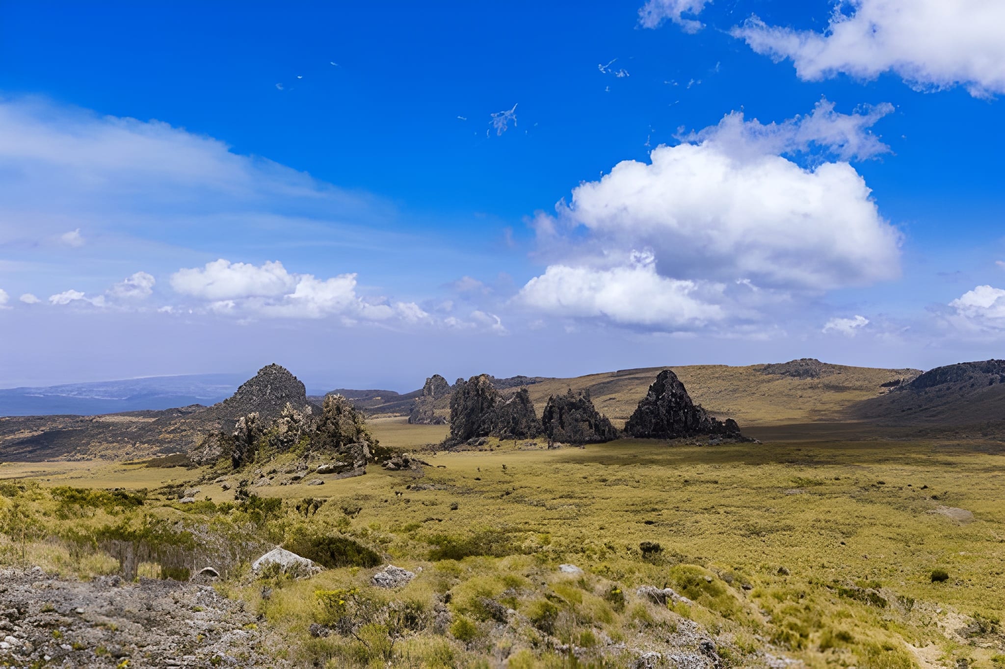
What makes this route genuinely special is what you encounter halfway: the Dragon's Teeth themselves — a corridor of jagged volcanic rock spires rising 10 to 15 metres from the open moorland, formed by ancient lava intrusions that hardened while the surrounding rock eroded away over millions of years. No other hiking trail in Kenya passes through a geological feature like this. It looks like a fantasy landscape. It is entirely real.
🎯 The honest truth:
Elephant Hill gets all the Instagram attention because it is closer to Nairobi. But Shamata is prettier, quieter, and the summit is 350 metres higher. The Dragon's Teeth route starts at 3,400m — meaning there is no bamboo tunnel, no dense forest approach, no confined warm-up section. You are on open moorland with views in every direction from the very first step. If you have one day and want the best experience the Aberdares offer without suffering for it, this is your trail.
📋 Trek at a Glance
| 🐂 Summit | Ol Donyo Lesatima (Mount Satima), 4,001m (13,127ft) |
| 🇰🇪 Ranking | 3rd highest mountain in Kenya · Highest in the Aberdares |
| 📈 Elevation Gain | ~600m from Twin Rocks trailhead |
| 📏 Distance | ~16km round trip |
| ⏱️ Time on Trail | 5–7 hours |
| 📍 Trailhead | Twin Rocks Picnic Site, ~3,400m |
| 🚪 Entry Gate | Shamata Gate or Rhino Gate, Nyandarua County |
| 💪 Difficulty | Moderate — Kenya's most accessible 4,000m summit |
| 🛣️ Distance from Nairobi | ~160km (approx. 3–3.5 hrs drive) |
| 🪖 Guide Requirement | Armed KWS ranger + certified guide — mandatory |
| 🐉 Signature Feature | The Dragon's Teeth volcanic formation — unique in Kenya |
| 👁️ Summit Views | Mount Kenya · Rift Valley Lakes · Laikipia · Mau Escarpment |
🐉 The Dragon's Teeth — What They Actually Are
Most people who see the Dragon's Teeth for the first time stop walking and just look. The formations rise from the open moorland without warning — jagged, dark, irregular spires of volcanic rock clustering in groups along a 1km corridor that the trail winds directly through. They look like something placed there deliberately. They were not.
These formations are composed of porphyritic trachyte — a type of volcanic rock that was intruded as magma into the surrounding moorland rock millions of years ago as the Aberdare Range was forming. The trachyte cooled and hardened underground, denser and more resistant to erosion than the surrounding material. As the millennia passed, wind and water wore away the softer surrounding rock — and the harder trachyte bodies were left standing, exposed at the surface in the shapes you walk through today.
The trail enters Dragon's Pass — the natural corridor framed by the tallest spires on both sides — at roughly the 5km mark. Standing inside the passage with the moorland visible ahead and the summit ridge above, you understand why this trail is the most photographed in the Aberdares.
Other named formations along the trail that most guides point out: Nipple Rock — a smooth dome-shaped outcrop near the start, the first rock feature encountered after leaving Twin Rocks; The Lost Pyramid, Muir's Massive, Weathering Heights, and the Theater of Heaven further along — each a different expression of the same ancient volcanic material, shaped differently by the same millions of years.
After Dragon's Pass, the trail rises more steeply for the final 2km to the summit. This is where the altitude is felt most directly — thin air, slower pace, shorter sentences. The summit itself is open, exposed, and enormous in view.
🕐 The Full Day — Hour by Hour
🚐 04:30 · Nairobi · Departure
The Land Cruiser is outside. Claim a window seat. The drive north via the Nakuru highway, past Flyover, through Ol Kalou and Shamata town takes about 3 to 3.5 hours. The road up to the Shamata gate is one of the most scenic mountain drives in Kenya — at some point you climb above the clouds and the whole highland plateau disappears below you, white and still, while the moorland opens ahead in clear morning light. Stop for chai at a roadside stall near Nyeri. Last proper bathroom until the return.
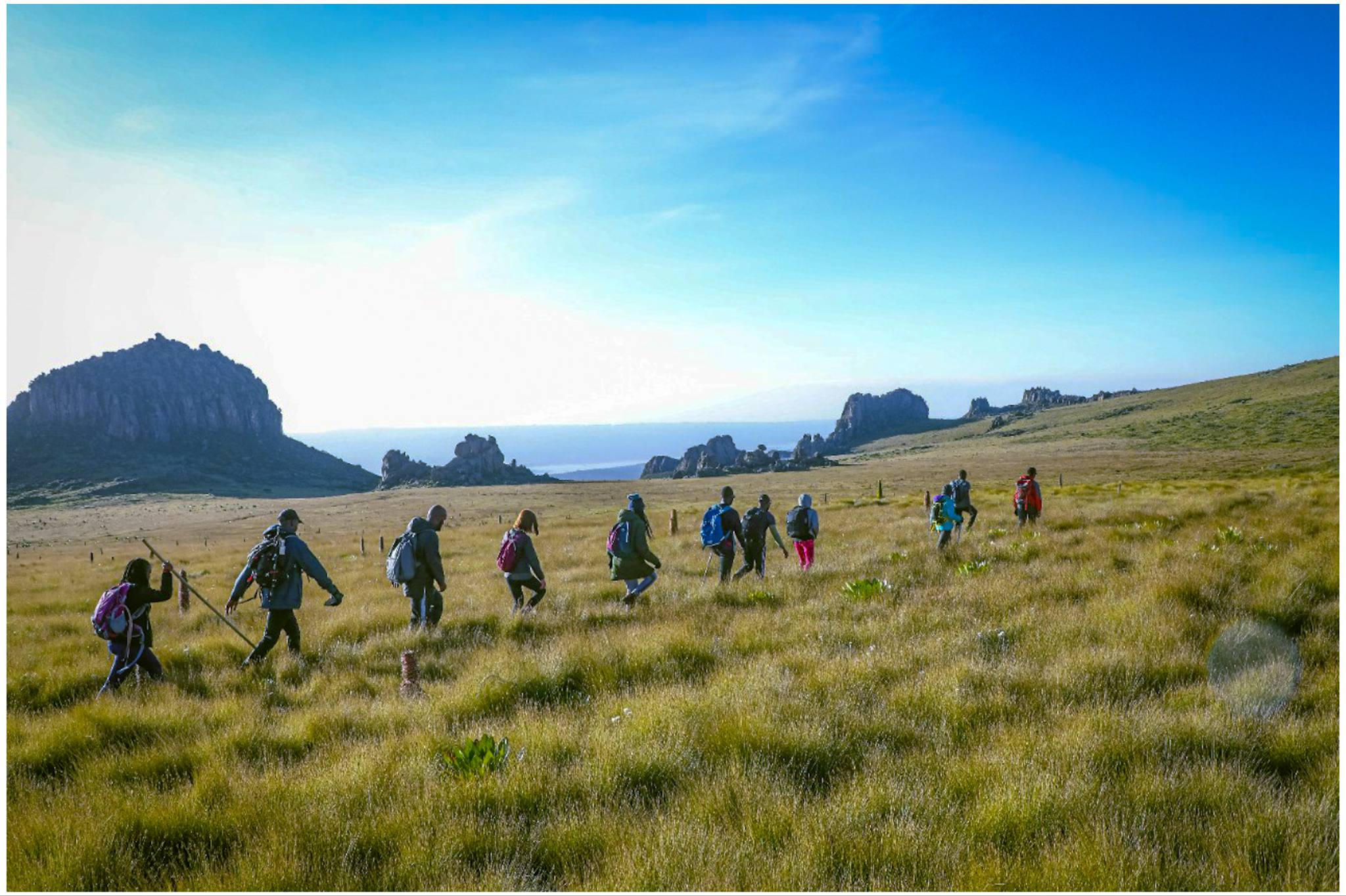
🏞️ 07:30 – 08:30 · Shamata Gate → Twin Rocks Drive-In
Entry fees paid at the gate. Armed KWS ranger collected. Then a 12km drive inside the park to the Twin Rocks trailhead at 3,400m. This drive is a wildlife safari in itself. Plains zebra, waterbuck, warthog, and eland are routinely spotted directly from the vehicle on this road. The moorland is open and vast — you can already see the rocky ridgelines ahead and the distant summit silhouette. Most first-timers forget they are going hiking and start photographing animals from the window.
📋 08:30 – 09:00 · Twin Rocks, 3,400m · Briefing & Start
The Twin Rocks landmark — two prominent boulders at the picnic site — is the official trailhead. Your guide briefs the group: the pace (slow and steady from the first step — you are already at altitude), the water schedule, and the mandatory 15:00 turn-back to avoid nightfall on the mountain. Then you walk north.
🌾 09:00 – 11:00 · 3,400m – 3,700m · Open Moorland — The Nipple & The Approach
From your very first step there are no trees, no canopy, no enclosed sections. Open Afro-alpine moorland stretches in every direction — tussock grass rolling in golden waves, Giant Heather (Erica arborea) draped in lichen and morning dew, Giant Lobelia (Lobelia deckenii) standing at the trail edge. The path is well-defined and the gradient gentle. Nipple Rock appears within the first 15 minutes — a smooth, dome-shaped volcanic outcrop that generates reliable commentary from every group. The rock formations become progressively larger and more dramatic as you gain altitude.
🪨 11:00 – 12:00 · ~3,700m – 3,800m · Dragon's Pass
The Dragon's Teeth appear ahead, then up close, then all around you. The trail enters the pass — framed by trachyte spires on both sides, the sky reduced to a strip above, the moorland visible ahead through the rock corridor. This is where almost every camera comes out and almost no one keeps walking at pace. Take the time. Eat your snack. Let your guide explain the geology. Photograph from every angle the formations allow.
Midway through the formations, the summit ridge becomes visible for the first time. From here the distance looks deceptive — it is 2km further and 200m of elevation, but the terrain is more exposed and the air noticeably thinner.
🏅 12:00 – 14:00 · 3,800m – 4,001m · Summit Push
The final section steepens. Rocky, occasionally boggy where drainage channels cross the trail, and demanding on the lungs at altitude. Hands are occasionally needed on the rockier sections — not scrambling, just stability. The summit is reached at 4,001m.
🏆 14:00 · 4,001m · OL DONYO LESATIMA — THE SUMMIT
The highest point in the Aberdares. The view earns the name young bull — it is confident and enormous. Mount Kenya's glaciated peaks to the east, enormous and white on clear mornings. The Rift Valley Lakes — Naivasha, Nakuru, Elementaita — glinting silver to the west. Laikipia's plains rolling north toward Ethiopia. Lake Ol Bolosat directly below to the north — Kenya's only freshwater lake on the highland plateau. On exceptional dry-season mornings, the Mau Escarpment 150km away is visible on the horizon. Eat your summit lunch here. Take every photograph you can before the afternoon cloud arrives.
15:00 — mandatory descent. Non-negotiable.
⬇️ 15:00 – 17:00 · 4,001m → 3,400m · Descent
The descent reverses the route — different light on the Dragon's Teeth (often better in the afternoon for photographs), faster pace, noticeably easier on the lungs, harder on the knees. Trekking poles earn their keep on the descent. Back to Twin Rocks by 17:00. The drive back to Nairobi takes 3 to 3.5 hours. Drop-off by 20:30. You will be tired, dusty, probably sunburned, and definitely satisfied. Not bad for a Tuesday.
🗺️ The Four Trail Sections
🌿 Section 1 · Twin Rocks → Nipple Rock · 3,400m – 3,550m
Broad open moorland, gentle gradient, first rock formations, first wildlife. The landscape is enormous from step one. Nipple Rock at ~1.5km is the first notable landmark and the natural first stop.
🪨 Section 2 · Nipple Rock → Dragon's Teeth · 3,550m – 3,800m
The trail progresses through progressively larger and more dramatic rock formations. This is the most photographed section of any trail in the Aberdares. Multiple named formations culminate in Dragon's Pass — the signature moment of the route.
⛰️ Section 3 · Dragon's Teeth → Summit Approach · 3,800m – 3,900m
The trail steepens past the formations. Open ridgeline, boggy channels, first real altitude effects. The summit ridge is visible ahead. Pace drops. The air is genuinely thin.
🏅 Section 4 · Final Push → Summit · 3,900m – 4,001m
Rocky, demanding, the most rewarding section per metre of elevation on any Aberdare trail. The summit plateau opens and the summit marker appears.
🌿 Flora
The Dragon's Teeth route runs entirely above 3,400m — which means pure Afro-alpine moorland species from the first step to the last.
Tussock grass (Deschampsia spp.) dominates the open sections in rolling golden fields. Giant Lobelia (Lobelia deckenii) — found only on East Africa's high mountains — stands at every drainage channel and rocky ledge, its tall rosette spikes reflecting the moorland scale. Helichrysum spp. (everlasting flowers) — a form endemic to the Aberdare highlands — clusters in gold and cream across exposed rocky faces. In the wetter sections between rock formations, Lady's Mantle (Alchemilla hageniae), a noted Aberdare endemic, fills the channels with its distinctive dew-catching leaves. Near the summit, Giant Senecio (Dendrosenecio battiscombei) — one of Africa's most ancient-looking high-altitude plants — stands on exposed ridges, its woolly silver-green crown unmistakable. The Aberdare Range holds 778 recorded plant species including 63 endemics. This route passes through the heart of their altitude range.
🦁 Wildlife & Nature
The Dragon's Teeth route's great wildlife advantage over all other Aberdare hikes is the 12km park road from the gate to Twin Rocks — a dedicated wildlife-watching drive through open moorland before you take a single hiking step.
| 🐾 Species | 👁️ Likelihood | 📍 Where |
|---|---|---|
| 🦓 Plains Zebra | ★★★★★ | Park road drive-in — routine sighting |
| 🦌 Waterbuck | ★★★★★ | Park road and open moorland |
| 🐗 Warthog | ★★★★☆ | Park road, lower moorland sections |
| 🦌 Eland | ★★★★☆ | Open grassland sections, near Twin Rocks |
| 🦌 Mountain Reedbuck | ★★★★☆ | Upper moorland near and above the Dragon's Teeth |
| 🐘 Forest Elephant | ★★★☆☆ | Forest edges on the drive in — less common on this route than Wandare |
| 🦬 Buffalo | ★★★☆☆ | Lower moorland and forest edge |
| 🐒 Black-and-White Colobus | ★★★★☆ | Bamboo and forest sections near Shamata Gate |
| 🦁 Serval Cat | ★★☆☆☆ | Open moorland above 3,500m |
🔭 Birding
This route is excellent for moorland and high-altitude bird species. Over 290 species are recorded in Aberdare National Park, a designated Important Bird Area (IBA).
- Aberdare Cisticola (Cisticola aberdare) — Kenya's only true highland endemic. The tussock moorland between Twin Rocks and the Dragon's Teeth is prime habitat.
- Jackson's Francolin (Pternistis jacksoni) — near-endemic to Kenya's central highlands; heard and seen regularly in the heather transition zone.
- Scarlet-tufted Malachite Sunbird — follows the Giant Lobelia flowering season; seen throughout the moorland sections.
- Mountain Buzzard & Augur Buzzard — soar above the moorland on morning thermals, particularly visible from inside the Dragon's Teeth corridor looking up.
- Moorland Chat — perches conspicuously on the Dragon's Teeth rock formations.
Log your sightings at the Aberdare National Park eBird hotspot.
💰 2026 Pricing — Per Person by Group Size
Everything included. No surprise charges at the gate.
| 👥 Group Size | 🇰🇪 Kenyan Citizens | 🌍 EA Residents | 🌐 International |
|---|---|---|---|
| 1 person (private) | KES 8,500 | KES 11,500 | USD 180 |
| 2 persons | KES 6,500 | KES 8,500 | USD 140 |
| 3 persons | KES 6,500 | KES 8,500 | USD 140 |
| 4 persons | KES 5,500 | KES 7,000 | USD 115 |
| 5 persons | KES 5,500 | KES 7,000 | USD 115 |
| 6 persons | KES 5,500 | KES 7,000 | USD 115 |
| 7 persons | KES 4,800 | KES 6,200 | USD 95 |
| 🚗 Self-drive (meet at gate) | KES 2,200 | KES 2,800 | USD 40 |
Groups of 8 and above — contact us for a custom quote. Traverse option (one-way with vehicle at both gates) carries a small logistics surcharge.
✅ What's Included
- 🚐 Return transport from Nairobi (4×4 vehicle, CBD/Westlands pickup)
- 🏞️ Aberdare National Park entry fees
- 🚗 Vehicle park entry fees
- 🪖 Mandatory armed KWS ranger for the full day
- 🧭 Certified Wild Springs mountain guide
- 🍱 Summit picnic lunch + trail snacks
- 💧 Drinking water (3 litres per person)
- 📸 Professional photography (digital gallery within 48 hours)
- 🩺 Emergency first aid kit and evacuation support
- 📋 All government taxes
❌ Not Included
- 👟 Personal hiking gear (rentals available — see below)
- 🛡️ Travel insurance (strongly recommended — purchase before trip)
- 🙏 Guide & ranger tips (KES 500–1,000 per person suggested — genuinely appreciated)
- 🍳 Breakfast (eat before pickup or bring snacks for the vehicle)
🎒 Gear Rentals
| Item | Daily Rate |
|---|---|
| 🥢 Trekking poles | KES 500 |
| 🦵 Gaiters | KES 300 |
| 🎒 Day pack (30L) | KES 400 |
⚠️ Safety on This Trail
⚠️ Altitude Is Real Even on the Gentle Route
The Dragon's Teeth route starts at 3,400m. There is no gradual altitude build-up — you are already high from the first step. Shortness of breath, mild headache, and reduced pace are normal and expected above 3,800m. Slow, steady, and well-hydrated is the correct approach. If symptoms worsen above 3,500m, descend immediately.
⚠️ Boggy Sections Throughout
The moorland between Twin Rocks and the Dragon's Teeth has water bog sections, particularly in the drainage channels between rock formations. Gaiters keep boots dry. Trekking poles give confidence on soft ground. Waterproof boots with ankle support are not optional.
⚠️ Afternoon Weather at 4,000m
Cloud moves in fast above 3,800m after 14:00 on the Shamata side. The 15:00 mandatory descent start is not a suggestion. Wild Springs guides enforce it consistently.
⚠️ Wildlife on the Drive and Trail
Buffalo and elephant sign is present in the lower moorland sections and forest edge near the gate. Your ranger walks between you and any encounter. Stay in your group, follow instructions.
🎒 What to Bring
🥾 Footwear & Lower Body
- Waterproof hiking boots with ankle support — broken in, not new. Trail runners are acceptable in dry season but not recommended.
- Gaiters — for the bog sections
- Long hiking trousers — wind at 3,800m bites bare legs
- Two hiking sock pairs
🧥 Clothing Layers
- Moisture-wicking base layer — no cotton
- Fleece or lightweight down mid-layer
- Waterproof, windproof shell — non-negotiable
- Warm hat and lightweight gloves for the summit
- Sun hat — UV at altitude is significant on open moorland
🎒 Gear & Food
- Trekking poles — save your knees on the descent
- 3 litres of water minimum
- Energy snacks for the trail in addition to the provided lunch
- Camera with fully charged battery — the Dragon's Teeth formations deserve it
- Binoculars — the summit views and the moorland birds reward them
- Sunscreen SPF 50+
- Headlamp (insurance against an unexpected late descent)
- Personal first aid: blister pads, paracetamol, personal medication
🏪 Gear available at the Wild Springs Outdoor Store. If this is your first high-altitude hike, ask our team specifically about layering for the 3,400m–4,001m temperature range.
📅 When to Go
| 📆 Month | ⭐ Conditions |
|---|---|
| January | ⭐⭐⭐⭐⭐ Ideal — clear summit views, firm trail |
| February | ⭐⭐⭐⭐⭐ Ideal — best clarity and photography light of the year |
| March | ⭐⭐⭐ Okay — early rains begin, bogs deepen |
| April | ⭐⭐ Avoid — long rains, heavy bog |
| May | ⭐ Avoid — worst conditions |
| June | ⭐⭐⭐⭐ Good — dry season opens, cold mornings |
| July | ⭐⭐⭐⭐⭐ Ideal — peak season |
| August | ⭐⭐⭐⭐⭐ Ideal |
| September | ⭐⭐⭐⭐ Good |
| October | ⭐⭐⭐ Variable — short rains possible |
| November | ⭐⭐⭐ Atmospheric — green and misty, good for moody photography |
| December | ⭐⭐⭐⭐ Good — rains ease off |
Book 2–3 weeks ahead for July–October. Weekends fill fastest.
🏅 Why Satima Before Mount Kenya
Smart climbers use Satima as a controlled test before committing to a multi-day expedition.
What Satima tells you that no gym session can:
1. How your body handles 4,000m. Every person responds differently to altitude. Some feel nothing above 3,500m. Others feel significant effects from 3,000m. Satima is the honest test. If the summit feels manageable, Point Lenana is within realistic reach. If it hits you hard, you know what to train and acclimatise for before booking Mount Kenya.
2. Whether your gear is right. New boots, new pack, new waterproof layer — test everything here where failure means a bad day, not a failed expedition at 4,800m.
3. Whether your pacing is sustainable. Six to seven hours of effort at altitude is a qualitatively different experience to six to seven hours at sea level. Satima tells you where your actual endurance sits.
If Satima via Dragon's Teeth feels comfortable, you are ready for Point Lenana. If it feels genuinely hard, you know exactly what to work on.
📊 Trail Comparison — Satima vs Other Aberdare Peaks
| 🏔️ Trail | ⬆️ Summit | 💪 Difficulty | 🎯 Best For | ⏱️ Time |
|---|---|---|---|---|
| 🌿 Mount Kipipiri | 3,349m | Moderate | Wildflowers, history, birding | 8–9 hrs |
| 🐘 Elephant Hill | 3,658m | Hard | First serious Aberdare challenge | 7–10 hrs |
| 🪨 12 Apostles | 3,672m | Very Hard | Kenya's toughest day hike | 12–17 hrs |
| 🗻 Table Mountain | 3,817m | Moderate | Scenic plateau, photography | 5–7 hrs |
| 💧 Seven Ponds | 3,826m | Hard | Glacial tarns, solitude | 7–10 hrs |
| 🌾 Rurimeria Hill | 3,860m | Strenuous | Mount Kenya training | 7–10 hrs |
| ⛰️ Kinangop | 3,906m | Hard–Very Hard | Technical summit, full ridge views | 9–12 hrs |
| 🐉 Satima Dragon's Teeth | 4,001m | Moderate | Best first 4,000m summit in Kenya · Most scenic Aberdare trail | 5–7 hrs |
Source: AllTrails — Aberdare National Park · Wild Springs guided records.
🔄 Traverse Option — Combine Both Routes
For hikers who want to see the full Satima experience in one day, the traverse combines the Dragon's Teeth ascent with a Wandare descent (or vice versa). Two different sides of the mountain, two completely different landscapes, one summit.
Ascend Dragon's Teeth → Descend Wandare: The Dragon's Teeth drama as your motivation on the way up, the raw Wandare moorland as your descent. Requires vehicle at both gates.
Ascend Wandare → Descend Dragon's Teeth: The harder route first, the most scenic route saved for the second half. The Dragon's Teeth formations look extraordinary in the afternoon light from above.
Contact Wild Springs to arrange vehicle logistics for the traverse. All traverse options are private booking.
👥 Private & Custom Options
👥 Private Groups
Any group size from 1 to 7 persons on this package. Your date, your pace, the full guide's attention. Pricing as per the table above — the per-person rate reduces as your group grows.
📸 Photography Groups
The Dragon's Teeth formations offer extraordinary photography at different times of day in different light conditions. We can arrange earlier departures and extended time in the formation corridor for dedicated photography groups.
🎯 Mount Kenya Preparation
Wild Springs can build a structured training sequence using the Dragon's Teeth route as a key altitude step. Contact us with your Mount Kenya expedition date and we design the preparation programme backwards from there.
🏢 Corporate Team Building
The Dragon's Teeth route is the right format for teams: accessible enough that most participants can complete it, dramatic enough that it feels genuinely significant, and the summit achievement is a shared reference point that outlasts the hike itself.
🗺️ Also on Mount Satima
This page covers the Dragon's Teeth route. For the complete Satima picture — including route comparison, traverse logistics, and the full Wandare experience:
- 🏅 Mount Satima — Complete Guide (Both Routes)
- 🌾 Mount Satima — Wandare Route Summit Challenge (for advanced hikers and acclimatisation training)
🤝 Why Wild Springs
- ⭐ TripAdvisor Award Winner — verified reviews from real hikers
- 🏛️ Kenya Tourism Authority Licensed — fully registered tour operator
- 🌍 TOSK Kenya Member — Tour Operators Society of Kenya
- 🧗 MCK Certified Guides — Mountain Club of Kenya; our Dragon's Teeth guides know this trail in all seasons and all conditions
- 📸 Professional Photography Included — digital gallery within 48 hours of your hike
- 🤝 Fair Pay — guides and rangers paid above industry standard
- 🌿 Leave No Trace — zero plastic policy, all waste carried out
💳 How to Book & Pay
📱 M-Pesa Paybill
- Paybill: 4065921
- Account: Satima
After payment, WhatsApp your name, date, group size, and pickup location to confirm.
🏢 Cash at the Office
Valley View Office Park, Tower A, First Floor, Sixth Avenue Parklands, off Limuru Road, Nairobi
Mount Satima Contacts
📞 +254 729 257 317 · +254 734 417 496 · +254 721 957 652
📧 [email protected] · wildspringssafaris@gmail.com
Where You Will Visit
This safari explores the following regions in Kenya
- Aberdares