💧 Seven Ponds Hike Aberdare Ranges, Kenya
Safari at a Glance
Where the Mountain Holds Water Above the Clouds
Wild Springs Adventures | 📍 Kwa Matu, Nyandarua County
🌊 The Ponds That Feed the Rivers
Most mountain summits reward you with a view. Rurimeria gives you the Rift Valley. Elephant Hill gives you the Kinangop Plateau. Satima gives you the whole range laid out below. Seven Ponds gives you something no other Aberdare summit can: water.
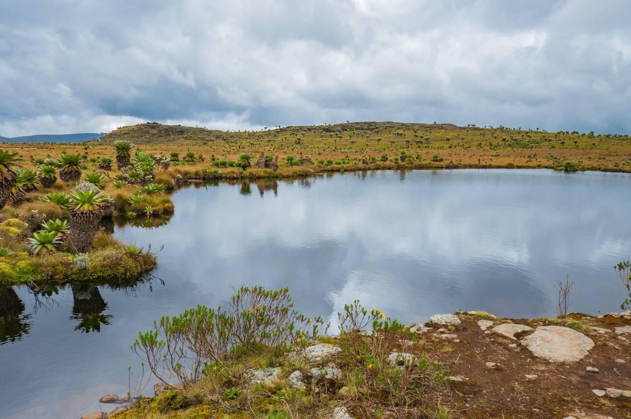
At 3,826 metres above sea level, perched on one of the flattest, most otherworldly plateaus in the Aberdare Range, seven ancient alpine ponds — glacial tarns — sit scattered across the moorland like mirrors dropped from the sky. They are permanent, year-round, crystal clear, and surrounded by giant lobelia and golden tussock grass. In the rainy season, an additional sixteen ponds emerge from the waterlogged plateau, bringing the total to twenty-three. On a calm morning with no wind, each pond reflects the sky above it perfectly. The photographs taken here are unlike anything else on the Aberdares.
These are not just scenic features. They are the source of rivers. The water sitting in these ponds at 3,826m eventually finds its way into River Chania — which flows through Murang'a all the way to the Indian Ocean — and into River Gitei and the Wanjohi, which join to form the River Malewa, feeding Lake Naivasha and Lake Ol Bolosat, Kenya's only natural freshwater lake on the highland plateau. When you stand at the Seven Ponds summit and look at the water around you, you are looking at the beginning of river systems that sustain millions of people below.
The trail itself sits in the geographical sweet spot of the northern Aberdare moorlands — sandwiched directly between Table Mountain to the northwest and Rurimeria to the northeast. From the summit plateau you can see both sister peaks simultaneously, along with Satima, Kipipiri, and on a clear day, the full ridge of Mount Kenya far to the north. No single viewpoint on the Aberdares puts more of the range in one frame.
It is the Aberdare trail for people who want the high moorland without the extreme steepness of Rurimeria, the dramatic landmark of Elephant Hill without its crowds, and a summit that rewards lingering. You sit down by one of the ponds. The water is still. The view is enormous. You eat your lunch. You are in no rush to leave.
🎯 The honest truth: Seven Ponds is often sold as "moderate." It is not. The elevation gain of nearly 1,000m in 11km is real, and the initial 2km are steep and relentless. What makes it feel different from Rurimeria or Elephant Hill is the payoff structure — the summit is flat, and once you reach the ponds, the hard work is done. You don't summit a rocky peak and immediately turn around. You arrive somewhere, and you stay. That is rare on any mountain. It is one of the things that makes Seven Ponds genuinely special.
📋 Trek at a Glance
| 💧 Summit Feature | Seven permanent glacial tarns at 3,826m (12,549ft) |
| 📈 Elevation Gain | ~995–1,040m from the electric fence gate |
| 📏 Distance | 11–14km round trip |
| ⏱️ Time on Trail | 7–10 hours |
| 📍 Trailhead | KWS Electric Fence gate, Kwa Matu, Nyandarua County |
| 🗓️ Trailhead Altitude | ~2,600m (8,530ft) |
| 💪 Difficulty | Hard — steep ascent, high altitude, boggy summit |
| 🛣️ Distance from Nairobi | ~155km (approx. 2.5–3 hrs drive) |
| 🪖 Guide Requirement | Armed KWS ranger + certified guide — mandatory |
| 📸 Photography Rating | ⭐⭐⭐⭐⭐ — best summit photography on the northern Aberdares |
🧊 What Are the Ponds? A Geology Worth Knowing
The seven permanent ponds at the summit of this trail are technically called tarns — a word from Old Norse meaning "small mountain lake without tributaries." They are not random pools. They are the legacy of a geological process that unfolded over tens of thousands of years.
During the last glacial maximum, small glaciers called cirque glaciers occupied the high bowls of the Aberdare Range. These glaciers carved and deepened their basins through the processes of plucking — where ice freezes onto bedrock and pulls rock away — and abrasion — where ice grinds across the rock surface like sandpaper. Over millennia, the glaciers gouged out bowl-shaped depressions called cirques in the mountain. When the climate warmed and the glaciers melted — the last Aberdare glaciers retreating perhaps 10,000 to 12,000 years ago — the meltwater collected in these over-deepened hollows. The seven ponds you hike to are those hollows, still full of water, still reflecting the sky, still in the exact shape the ice left them.
The ponds are typically less than a hectare each. They are cold and clear. They sit at 3,826m on a flat plateau where the wind can be fierce and the temperature drops fast after noon. In the rainy season, as rainfall tops up the waterlogged moorland, sixteen more seasonal ponds appear across the plateau, making the total count twenty-three. The contrast between the grey-green tussock grass, the deep blue-black water, and the giant lobelia standing at the edges is something camera lenses struggle to fully capture.
These are the only glacial tarns at the summit of any Aberdare hiking trail. That geological uniqueness is, among other things, what makes the Seven Ponds trail worth the effort.
🕐 The Full Day — Hour by Hour
🚐 04:30 – 05:00 · Nairobi · Departure
The drive is about 2.5 to 3 hours — shorter than Rurimeria, longer than Elephant Hill. The road north passes through Naivasha and climbs onto the Kinangop Plateau. The turn toward Kwa Matu brings you into the northern Aberdare foothills. By the time you reach the electric fence gate at Kwa Matu, the morning is still fresh. The summit you are heading for is not visible yet. The moorland above it is always hidden until you have earned it.
📋 07:30 – 08:00 · KWS Electric Fence Gate, ~2,600m · Briefing & Start
Park entry fees paid. KWS armed ranger collected. Your guide briefs the group. One thing to note before you start: the Table Mountain trail goes left from this gate. Seven Ponds goes straight ahead and to the right. They share the same trailhead but diverge almost immediately. You take the right fork and begin.
⛰️ 08:00 – 10:00 · 2,600m – 3,100m · The First 2km — No Mercy
The trail begins immediately with 2km of steep, twisting ascent. There is no flat section here, no gentle warm-up. The path winds through indigenous trees and dense vegetation, gaining altitude hard and fast. This is the part that surprises people. By the time you reach the viewpoint at roughly 1.5km from the gate — a rocky opening with your first views back over the Kinangop Plateau, Kwa Matu below, and the silhouette of Kipipiri to the west — your heart rate is already high and your legs are already talking to you. Stop here. Look back. Eat something small. The worst climbing is done.
🌿 10:00 – 11:30 · 3,100m – 3,400m · Indigenous Trees, Rocky Outcrops & Views
After the viewpoint the character of the trail changes. The vegetation shifts from dense lower forest to more open indigenous trees — the trail gently steepens but the drama of the first section has passed. Rocky outcrops provide natural rest points and framing for photographs looking across the Aberdare valleys. The views of Rurimeria to the northeast and Table Mountain to the northwest begin appearing through gaps in the vegetation. You can see both sister peaks from here. At the base of the rocky section, altitude effects may begin — thin air above 3,000m is the constant companion on every Aberdare trail. Slow your pace. Breathe steadily.
⚠️ This is where hikers who underestimated the trail start struggling. The first 2km were steep; this section is deceptive because it looks easier but the altitude compounds the effort. Drink water. Do not rush.
🌾 11:30 – 13:00 · 3,400m – 3,826m · The Golden Moorland & The Ponds
The rocky section gives way and the moorland opens. What comes next is why people come back. The Seven Ponds moorland is described by almost everyone who has hiked it as one of the most beautiful stretches of trail in the Aberdares. Golden tussock grass rolling in every direction. Giant lobelia standing at the edge of the path. The air is cold, crisp, and completely still in the right conditions. You can see Lesatima to the north and the full Aberdare ridge. Then the summit plateau flattens. And then you see the first pond — a dark mirror of sky and grass, perfectly still — and behind it, another, and another.
🏆 13:00 · 3,826m · THE SEVEN PONDS — The Rarest Summit on the Aberdares
Find a dry rock above the largest pond. Take off your pack. Sit down. Look at what is in front of you: seven alpine ponds, each one reflecting the sky and the giant lobelia at its edge, scattered across a vast flat moorland plateau with the full Aberdare ridgeline as a backdrop. In one direction, Rurimeria's summit. In another, Table Mountain's flat top. Beyond that, Satima. Below to the west, Kipipiri. Below to the east, the valleys feeding all the way down to Nairobi. Eat your lunch here. It is the best picnic table in Nyandarua County.
14:30 — turnaround. Afternoon fog above 3,400m is real and makes descent navigation in the moorland hazardous.
⬇️ 14:30 – 17:30 · 3,826m → 2,600m · Descent
The descent retraces your ascent. The steep initial section is slippery after rain — poles and attention to footing are essential. In wet conditions, the rocky section can become treacherous. Take your time. Back through the electric fence by 17:00. Vehicle by 17:30. Nairobi by 20:00. You will sleep in the car. Your legs will feel it tomorrow. The photographs on your phone from the ponds will make it entirely worth it.
🗺️ The Four Trail Sections
⛰️ Section 1 · 2,600m – 3,100m · The Steep Opening
2km of relentless ascent. Twisting trail through dense vegetation. No flat, no rest, no mercy. The viewpoint at 1.5km is your first reward and the clearest signal that the trail takes you seriously.
🌿 Section 2 · 3,100m – 3,400m · Indigenous Forest & Rocky Outcrops
Vegetation opens up. Indigenous montane trees. Rocky resting points. First views of both sister peaks — Rurimeria and Table Mountain — visible simultaneously from the same section of trail. Altitude effects begin.
🌾 Section 3 · 3,400m – 3,826m · The Golden Moorland
The most visually arresting section of trail on the northern Aberdares. Tussock grassland, giant lobelia, cold air, and views in four directions. The moorland here is described consistently as richer and more extensive than Table Mountain's equivalent section.
💧 Section 4 · 3,826m · The Summit Plateau & The Seven Ponds Flat. Remarkable.
The only glacial tarn field at the summit of any Aberdare hiking trail. Seven permanent ponds. Up to twenty-three in the rainy season. Reflects the sky perfectly on still mornings.
🌸 Flowers & Plants Along the Trail
Seven Ponds passes through some of the most photographically compelling plant communities in the northern Aberdares — a living progression of altitude zones that changes completely every few hundred vertical metres.
In the lower section, the trail passes through dense indigenous montane forest where African pencil cedar (Juniperus procera) and East African camphor (Ocotea usambarensis) form the canopy. Wild ginger and ferns carpet the forest floor in the wetter channels. Mosses drape the tree trunks in the damper sections — thick, deep green, a texture unlike anything at lower altitude.
As the trail opens into the rocky middle section, Helichrysum spp. — the everlasting flowers, gold and cream — begin appearing in clusters on the exposed rocky faces. These plants are endemic to the Aberdare Range in the Helichrysum gloria-dei form, and they retain their colour and form long after the bloom has dried, which is why they are called everlasting. Lady's Mantle (Alchemilla spp.) fills the drainage channels and wetter sections with its velvety, dew-collecting leaves — water beading perfectly on the surface in the early morning.
On the moorland plateau, tussock grass (Deschampsia spp.) dominates in rolling waves, punctuated by the towering spikes of Giant Lobelia (Lobelia deckenii) — the plant most people photograph first at the ponds. Each lobelia spike can grow to over two metres tall, with rosette leaves radiating from a central column. They are found only in the afro-alpine zones of East Africa's highest mountains. At the pond edges, Lobelia deckenii stands reflected in the still water — the image that defines Seven Ponds for everyone who has seen it. Dendrosenecio battiscombei, the giant groundsel — one of the most ancient-looking plants on earth, with its woolly silver-green crown on a thick stem — appears on the upper moorland, a living reminder that this landscape has not fundamentally changed since the glaciers left.
The Aberdare Range holds 778 recorded plant species. The Seven Ponds moorland contributes some of the most striking and least-visited members of that count.
🦁 Wildlife & Nature
The Seven Ponds trail sits within Aberdare National Park, a designated Important Bird Area (IBA) recording over 290 bird species. The moorland plateau at the summit is one of the highest-elevation open habitats in the park and supports a distinct community of species.
| 🐾 Species | 👁️ Likelihood | 📍 Where | 📝 Note |
|---|---|---|---|
| 🦌 Mountain Reedbuck | ★★★★☆ | Summit moorland | Common at the ponds and upper grassland, often seen grazing near the water edge at dawn |
| 🐘 Forest Elephant | ★★★☆☆ | Lower forest section | Tracks on the trail are regular. The armed ranger walks between you and any sighting. |
| 🦬 Buffalo | ★★★☆☆ | Forest-moorland transition | Groups often move through the transition zone; move quietly and follow ranger instructions |
| 🦁 Serval Cat | ★★☆☆☆ | Open moorland | Rare but confirmed. The Aberdare moorland is one of Kenya's best serval habitats — they are simply hard to spot |
| 🦌 Eland | ★★☆☆☆ | Upper moorland plateau | Africa's largest antelope occasionally grazes the open plateau near the ponds |
| 🐒 Black-and-White Colobus | ★★★★☆ | Lower forest | Reliable in the indigenous forest section on the way up |
| 🐦 290+ Bird Species | ★★★★★ | All zones | See birding section below |
🔭 Birding at Seven Ponds — The Moorland Specialists
The flat summit plateau at 3,826m is prime habitat for the Aberdare's most sought moorland birds. The combination of open tussock, pond edges, and exposed rocky areas creates a textbook mosaic of high-altitude bird habitat.
- Aberdare Cisticola (Cisticola aberdare) — Kenya's only true highland endemic, found nowhere else on Earth. The tussock moorland at the ponds is among its best habitat in the range. Listen for its sharp call carrying across the open plateau.
- Jackson's Francolin (Pternistis jacksoni) — near-endemic to Kenya's central highlands, regularly seen in the heather-tussock transition zone on the upper ascent.
- Scarlet-tufted Malachite Sunbird (Nectarinia johnstoni) — the moorland sunbird, following the giant lobelia flowering cycle. Often seen hovering at the lobelia spikes near the pond edges.
- Moorland Chat (Pinarochroa sordida) — an open-country specialist that perches on tussock tops and rocks near the ponds. Common and conspicuous at the summit plateau.
- Mountain Buzzard and Augur Buzzard — circle above the moorland on the morning thermals.
- African Stonechat (Saxicola torquata) — visible on exposed rocks from the viewpoint all the way to the summit.
Log your sightings at the Aberdare National Park eBird hotspot. The Seven Ponds summit plateau sits at the highest confirmed foraging elevation for Aberdare Cisticola in the range.
💧 The Ponds and the Rivers Below
Standing at the Seven Ponds, you are standing at the source of water that travels hundreds of kilometres to the sea.
River Chania flows from the northern Aberdare moorlands — receiving water from the plateau that includes the Seven Ponds catchment — and runs southeast through the forests of Murang'a County, past Thika, and eventually reaches the Indian Ocean through the Tana River system. The water in your hiking boots right now will reach the Indian Ocean within weeks.
River Gitei and the Wanjohi collect from the western slopes and join to form the River Malewa, which flows north and west down the Aberdare escarpment into Lake Naivasha — one of Kenya's most important freshwater lakes, a Ramsar Convention wetland, and home to some of East Africa's most concentrated birdlife. From Lake Naivasha, water feeds into Lake Ol Bolosat — Kenya's only natural freshwater lake sitting on the highland plateau — via the Malewa river system.
The Aberdare Range is the water tower of central Kenya. The Seven Ponds sit at the very top of that tower.
📸 Photography at Seven Ponds — A Dedicated Guide
Seven Ponds is the best photography destination on the northern Aberdares. Here is how to make the most of it:
🌅 Morning light (07:00 – 10:00) is the golden window. The ponds are still and reflective before the afternoon wind arrives. Giant lobelia backlit against the early sky is the signature image of this trail. Arrive at the ponds before 13:00 to catch the best conditions.
📷 The reflection shot — lie flat or crouch low at the pond edge. The reflection of Rurimeria, Satima, or the sky in the still water fills the frame completely. A wide-angle lens or phone in panorama mode works well.
🌿 The lobelia portraits — each Giant Lobelia at the pond edge is a subject in itself. In the right morning light with mist behind it, the rosette leaves glow. A 50mm equivalent focal length is ideal.
🦌 Wildlife at the ponds — Mountain Reedbuck often graze at the pond edges in the early morning. Be patient at the first pond you reach before moving toward the others.
🌈 Rainy season (October–December, March–May) — the additional sixteen ponds appear, turning the plateau into an extraordinary reflecting surface. Cloud movement and mist between showers creates dramatic, moody light. Worth the wet trail if you are a serious photographer.
💰 Pricing — 2026
No hidden charges at the KWS gate. Everything below is complete.
| 🇰🇪 Kenyan Citizens | 🌍 East African Residents | 🌐 International |
|---|---|---|
| KES 4,999 per person | KES 5,700 per person | USD 99 per person |
Group discounts apply for 5+ people. Contact us for a private group quote.
✅ What's Included
- 🚐 Round-trip transport from Nairobi (CBD/Westlands pickup)
- 🏞️ Aberdare National Park entry fees
- 🪖 Mandatory armed KWS ranger for the full day
- 🧭 Certified Wild Springs mountain guide
- 🍱 Packed lunch and trail snacks
- 💧 Drinking water
- 🩺 Emergency first aid kit and evacuation support
❌ Not Included
- 👟 Personal hiking gear: waterproof boots, gaiters, warm layers
- 🙏 Guide & ranger tips (KES 1,000–2,000 suggested)
- 🛡️ Travel insurance (strongly recommended)
- 📸 Professional photography (available on request)
- ➕ Optional traverse extension to Table Mountain (see below)
➕ Traverse Extension — Seven Ponds + Table Mountain
The most ambitious single-day objective on the northern Aberdares: ascending to Seven Ponds, then continuing northwest across the high moorland to summit Table Mountain (3,817m), and descending via the Table Mountain trail. A full moorland traverse above 3,400m between two summits.
Distance: +8km · Time: +3–4 hours · Additional cost: +$40 per person
Requires pre-booking, a 06:00 start from Nairobi, minimum 4 participants, and a physically fit group with strong altitude tolerance. This is the most complete day on the northern Aberdare ridge and one of the best hikes in the country. Enquire when booking.
🎒 What to Bring
🥾 Footwear & Lower Body
- Waterproof hiking boots with ankle support — the boggy summit plateau and rocky middle section both demand them
- Gaiters — the tussock moorland is wet and hides ankle-twisting gaps between grass clumps
- Long trousers — essential for the dense lower forest
- Two pairs of hiking socks — one dry spare in the pack
🧥 Clothing Layers
- Moisture-wicking base layer — no cotton, ever
- Insulating mid-layer — fleece or lightweight down
- Waterproof, windproof shell — afternoon conditions above 3,400m shift fast
- Warm hat and gloves — the summit plateau is cold and often windy even in dry season
- Sun hat and sunglasses — UV is severe in the open moorland
🎒 Gear & Food
- Trekking poles — highly recommended for the steep descent in particular
- 3 litres of water — no reliable sources above the electric fence gate
- Packed lunch and high-energy snacks
- Camera and/or binoculars — this trail rewards both
- Waterproof bag or dry liner for your pack
- Headlamp with batteries
- Sunscreen SPF 50+
- Personal first aid: blister pads, paracetamol, personal medication
🏪 Gear available at the Wild Springs Outdoor Store. Our lead guide Tim advises on kit for this specific trail, including gaiters for the tussock moorland.
⚠️ Safety on This Trail
⚠️ The Opening Section Is Harder Than It Looks
The first 2km are the steepest on the trail and the coldest mentally — steep, enclosed, relentless. People who expect a gentle start from the flat Kwa Matu approach are surprised. Know this going in. Pace yourself from the very first step.
⚠️ Boggy Summit — Ankle Hazard
The summit plateau is a raised bog. Tussock grass clumps are the stepping stones — between them the ground is saturated and will swallow a boot to the ankle. Walk on the grass clumps, not between them. Gaiters are not optional.
⚠️ Afternoon Fog and Wind at Summit
The flat plateau at 3,826m offers no shelter. After 13:00, cloud frequently moves in from the west. Whiteout in the moorland with no prominent features makes navigation genuinely dangerous. Be at the ponds before 13:00 and begin descent by 14:00 at the latest.
⚠️ Altitude Sickness
A 1,000m gain in a single morning is significant, especially from Nairobi's 1,700m. Headache, nausea, and fatigue are the warning signs above 3,000m. Descend immediately if symptoms worsen. Our guides are trained in acute mountain sickness recognition.
⚠️ Slippery Descent After Rain
The rocky middle section and the steep initial kilometre become genuinely dangerous when wet. Trekking poles and patience are your only tools here. Slower than comfortable is the right pace on the way down.
📅 When to Go
Seven Ponds is at its most photogenic when the ponds are still and clear. Rainy season brings extra ponds but boggy conditions.
| 📆 Month | ⭐ Conditions |
|---|---|
| January | ⭐⭐⭐⭐⭐ Ideal — dry, clear, ponds still and reflective |
| February | ⭐⭐⭐⭐⭐ Ideal — best photography conditions of the year |
| March | ⭐⭐⭐ Okay — rains begin, extra seasonal ponds appear |
| April | ⭐ Avoid — long rains, plateau becomes extremely boggy |
| May | ⭐ Avoid — worst conditions, trail hazardous |
| June | ⭐⭐⭐⭐ Good — dry season returns, clear mornings |
| July | ⭐⭐⭐⭐⭐ Ideal |
| August | ⭐⭐⭐⭐⭐ Ideal |
| September | ⭐⭐⭐⭐ Good |
| October | ⭐⭐⭐ Variable — short rains begin; extra ponds start to appear |
| November | ⭐⭐ Risky — maximum seasonal pond count but most demanding conditions |
| December | ⭐⭐⭐⭐ Good — rains ease off |
Photography note: The rainy season outer months (March, October–November) offer the largest pond count — up to 23 — and dramatic mist and cloud photography conditions. For the classic mirror-reflection shot, January, February, July, and August are the months.
📊 How Seven Ponds Compares to Other Aberdare Trails
| 🏔️ Trail | ⬆️ Summit | 💪 Difficulty | 🎯 Best For | ⏱️ Time |
|---|---|---|---|---|
| 🌿 Mount Kipipiri | 3,349m | Moderate | Wildflowers, history, birding, traverse | 8–9 hrs |
| 🐘 Elephant Hill | 3,658m | Hard | First serious Aberdare challenge | 7–10 hrs |
| 🪨 12 Apostles | 3,672m | Very Hard | Extreme challenge, peak baggers | 12–14 hrs |
| 🗻 Table Mountain | 3,817m | Moderate | Scenic, photography, moorland plateau | 5–7 hrs |
| 💧 Seven Ponds | 3,826m | Hard | Glacial tarns, photography, high moorland solitude | 7–10 hrs |
| 🦏 Rhino Hill | ~3,800m | Hard | Ridge traverse | 8–9 hrs |
| 🌾 Rurimeria Hill | 3,860m | Strenuous | Serious Mount Kenya training | 7–10 hrs |
| ⛏️ Kinangop | 3,906m | Hard | Technical, exposed ridges | 7–9 hrs |
| 🏅 Satima | 4,001m | Moderate | Highest Aberdare, gentler from north | 4–6 hrs |
Seven Ponds is the only Aberdare trail whose summit reward is a landscape feature rather than a view — the ponds are the destination, not just the endpoint. That distinction places it in a category entirely its own.
Source: AllTrails — Aberdare National Park · Wild Springs guided experience.
👥 Private & Custom Options
👥 Private Groups
Seven Ponds is the ideal private group trail for hikers who want a serious altitude challenge and a summit worth sitting at. Private booking means your own pace — and at the ponds, there is no rush. You can stay as long as the weather allows.
📸 Photography Groups
Seven Ponds is our most frequently booked trail for dedicated photography groups. Custom timing — earlier departures for dawn light at the ponds, extended summit time, slower pace through the lobelia sections — can be arranged for photography-focused groups. Contact us with your brief.
🏢 Corporate Teams
The trail has a structure that works well for team building: a hard opening that requires collective pacing, a middle section that rewards patience, and a summit that gives everyone equal time to absorb the experience. The ponds are a destination that requires no explanation — the group simply arrives and understands.
🎯 Mount Kenya & Kilimanjaro Training
Seven Ponds is an exceptional altitude conditioning hike. The near-1,000m gain, the 3,826m summit altitude, and the sustained effort across 7–10 hours mirror the demands of a high-altitude expedition day. Wild Springs can design a structured training programme incorporating Seven Ponds, Rurimeria, and beyond. Contact us with your expedition target.
🤝 Why Wild Springs
- ⭐ TripAdvisor Award Winner — verified reviews from real hikers and climbers
- 🏛️ Kenya Tourism Authority Licensed — fully registered tour operator
- 🌍 TOSK Kenya Member — Tour Operators Society of Kenya
- 🧗 MCK Certified Guides — Mountain Club of Kenya certified
- 🤝 Fair Pay — guides and rangers paid above industry standard, always
- 🌿 Leave No Trace — zero plastic policy, all waste carried out, no fires on the mountain
🏔️ What Comes Next
Seven Ponds sits in the middle of the Aberdare progression. Where you go next depends on how the ponds felt.
- 🗻 Table Mountain Traverse — continue the moorland ridge immediately to the northwest
- 🌾 Rurimeria Hill Moorland Trek — the serious Mount Kenya preparation hike, one ridge to the east
- 🐘 Elephant Hill — the southern Aberdares, different character entirely
- 📅 Mount Kenya Group Treks 2026 — fixed departure dates for the next step
- 💪 Mount Kenya Fitness Programme — 8-week structured training plan
- 🎒 Gear Checklist — everything you need for this trail and beyond
- 🏪 Wild Springs Outdoor Store — boots, gaiters, trekking poles, base layers
💳 How to Book & Pay
📱 M-Pesa Paybill
- Paybill: 4065921
- Account: "Seven Ponds"
After payment, WhatsApp your name, date, and group size to confirm your booking.
🏢 Cash at the Office Valley View Office Park, Tower A, First Floor Sixth Avenue Parklands, off Limuru Road, Nairobi
💧 The Ponds Are Waiting
Seven Ponds runs every weekend throughout the dry season. The water has been there for ten thousand years. The giant lobelia will be standing at the edge. The sky will be reflected. The only variable is whether you show up prepared.
📞 +254 729 257 317 · +254 734 417 496 · +254 721 957 652
Where You Will Visit
This safari explores the following regions in Kenya
- Aberdares