🏔️ The Aberdares North To South Traverse Kenya's Only Full Mountain Range Trek · 72Km · 5 Days · 4 Nights
Safari at a Glance
Wild Springs Adventures | 📍 Mweiga / Shamata Gate → Njabini Gate · Nyandarua County
Kenya's Only Complete Mountain Range Expedition · 5 Days / 4 Nights
Twin Rocks → Dragon's Teeth → Satima → Rhino Hill → Table Mountain → Seven Ponds → Rurimeria → Chania Falls → Mutubio → Kinangop → Elephant Hill
🌿 One Mountain Range. Every Summit. One Unbroken Journey.
There is no other trek in Kenya like this one.
Not because it is the longest. Not because it has the highest summit. But because it is the only route that asks you to walk the entire spine of the Aberdare Range — from the Dragon's Teeth corridor in the north all the way to Elephant Hill above Njabini in the south — as a single, uninterrupted journey. No return to the car. No Nairobi hotel between days. Just the range, your team, the tents, and every terrain zone the Aberdares contains.
You start among volcanic rock spires at 3,750 metres. You summit Kenya's third-highest mountain. You sleep on a flat plateau at 3,817m with cliff edges on three sides and no artificial light in any direction. You walk through ancient glacial tarn fields. You climb Rurimeria's strenuous ridge from the west, a direction most day-hikers never see. You camp beside the infant Chania River — the same water that eventually becomes Kenya's tallest waterfall, 273 metres of falling water at Karuru. You push through bamboo jungle so dense that elephants have carved the only usable paths. You follow those elephant highways. Your ranger leads. You trust completely. You earn the camp below Kinangop Peak with cold hands and the knowledge that no road brought you here. And on the final morning, you climb Elephant Hill — the traverse's last summit — and you can see every peak you've crossed over the previous four days laid out behind you to the north.
There is nothing in the day-hike world that produces this feeling. Nothing on a day trip earns the view from Elephant Hill at the end of four days of continuous mountain. The sense of achievement here is comparable to none.
🎯 Who this traverse is built for:
Serious hikers who want more than a summit and a car ride home. Mountaineers preparing for Kenya's larger objectives. Military personnel looking to challenge themselves again in a wilderness environment that demands everything they were trained to give. Corporate teams who have read about resilience and want to live it. Adventurers who understand that the best moments don't arrive in comfortable order — they have to be earned, across multiple days, with the right team, in genuine wilderness.
📋 Traverse at a Glance
| 🏔️ Full Route | Twin Rocks → Dragon's Teeth → Satima → Old Satima → Rhino Hill → Table Mountain → Seven Ponds → Rurimeria → Chania Falls Camp → Mutubio → Kinangop → Elephant Hill → Njabini |
| 📏 Total Trek Distance | ~74km across trekking days |
| ⛺ Duration | 5 Days / 4 Nights (Night 1: hotel · Nights 2–4: field camping) |
| 🏁 Entry Gate | Shamata Gate or Rhino Gate (Nyeri side) |
| 🏁 Exit Gate | Njabini Gate (Nyandarua / Murang'a boundary) |
| 📈 Highest Point | Mount Satima, 4,001m (Day 2) |
| 🏔️ Every Summit Crossed | Dragon's Teeth · Satima · Old Satima · Rhino Hill · Table Mountain · Seven Ponds · Rurimeria · Kinangop · Elephant Hill |
| 🗺️ Terrain | Moorland · volcanic rock · moorland bog · Hagenia forest · bamboo jungle · alpine meadow |
| 💪 Difficulty | Expedition — super-fit hikers only |
| 🪖 KWS Ranger | Armed — mandatory all trekking days |
| 🍽️ Meals | Night 1: hotel (dinner + breakfast) · Days 2–6: full board in the field |
| 🎒 Porters | Included - 1 porter per 2 trekkers |
| 🧰 Gear Check | Mandatory before departure - your safety is our greatest concern |
⚠️ Before You Book - The Gear Check
We inspect your kit before you enter the Aberdares. This is not negotiable.
The traverse passes through terrain that exposes every piece of equipment to conditions it may not have been designed for. The bamboo section on Day 5 is genuinely wet, genuinely muddy, and genuinely difficult in a way that substandard gear makes dangerous rather than merely uncomfortable.
🥾 Footwear: Fully waterproof, broken-in hiking boots with ankle support — proven above 3,000m. Not water-resistant. Not new. Day 5 involves a river crossing and prolonged mud immersion. Boots that fail here fail you when there is no turning back.
🧤 Gaiters: This traverse demands world-class gaiters. We recommend SFS-type gaiters — fully waterproof, snakeproof, and structurally stronger than regular trekking gaiters. The bamboo salient is active wildlife country. Standard gaiters may not hold through the Mutubio–Kinangop section. We inspect these at the gear check.
🧥 Insulation: The high camp below Kinangop Peak is at ~3,600m in wind-exposed moorland. Temperatures approach 0°C overnight. Sleeping bag rated minimum −5°C. Liner recommended. Fleece and down mid-layers are mandatory.
🎒 Daypack: 35–40L for personal items, water, snacks, camera, and layers. Porters carry camp equipment. Larger packs punish you in the bamboo.
If your gear is not adequate, we help you source what is missing before the traverse departs. We do not let the expedition begin with compromised equipment.
💰 Why Aberdare Multi-Day Treks Cost What They Do
The Aberdare Range is not Kilimanjaro with its graded porter highways and fixed mountain huts. It is a 160-kilometre volcanic ridge through equatorial Africa — alternating between sinking moorland bog, near-vertical bamboo jungle, dense indigenous forest, and wind-blasted ridgelines — with active elephant and buffalo throughout, no permanent facilities, no established trail between several key connecting sections, and a legal KWS requirement for armed ranger escort from start to finish.
The terrain demands extra from every category of support:
🚐 Double logistics:
Two vehicles on opposite sides of the range simultaneously. A third vehicle movement for the Mutubio resupply on Day 4.
👷 Extra labour:
A full porter team. A field chef. A ranger. A traverse-experienced lead guide who has walked every connecting section independently, including the unmarked moorland between Seven Ponds and Rurimeria and the bamboo river section approaching Kinangop.
🔄 Mid-traverse resupply:
The Mutubio Camp resupply on Day 4 brings fresh food, fuel, and water into the park. This is the infrastructure that makes a five-day field expedition possible. It is invisible to the trekker and entirely real in cost.
🌿 Genuine jungle support:
The Day 5 bamboo section requires enhanced porterage — loads that move in 30 minutes on open moorland take 2 hours through dense bamboo. The team carries every kilo of it.
This is a 100% wilderness expedition. The cost is the guarantee that it remains remote, safe, and exceptional. Every shilling of it is earned on the trail.
🗓️ The Full Traverse — Day by Day
🏨 Day 1 · Nairobi → Juniper Green Gardens Resort, Mweiga · Acclimatisation
Drive: ~160km · ~3 hours · Arrival altitude: ~1,800m
14:00 · Comfortable Afternoon Departure from Nairobi No 04:30 alarm for Day 1. The group travels north through Thika, Karatina, Nyeri town, and up the Nyeri-Nyahururu highway to Mweiga. As the altitude rises, the temperature drops and the familiar farmland gives way to a cleaner, colder landscape. The Aberdare escarpment builds on the right — the ridge you will walk end to end for the next four days.
17:30 · Juniper Green Gardens Resort · Mweiga · ~1,800m
A well-regarded resort on the Nyeri-Nyahururu Road, close to both Rhino Gate and Wandare Gate entrances to Aberdare National Park. Views of the Aberdare escarpment and Mount Kenya on clear evenings. Free WiFi. Hot showers. A restaurant that will cook a proper dinner. This is the last comfortable bed, the last hot shower, and the last reliable internet before Njabini Gate on Day 6.
Why this night matters: Nairobi is at 1,700m. The Twin Rocks trailhead is at 3,400m. Arriving there in a single morning — as the 4-day option requires — is a physiologically aggressive jump. Sleeping at Mweiga at ~1,800m narrows that by one altitude step. It is the difference between arriving at the trailhead with a functional body and arriving with the headache that costs hours of pace and summit quality for the rest of the traverse. The mountains reward this preparation.
Full traverse briefing over dinner tonight. Route maps, daily distances, wildlife protocols, campsite rules, water sourcing, emergency communication plan. Day 2 departs at 04:30.
🏨 Night 1 · Juniper Green Gardens Resort · ~1,800m · Hot shower · WiFi · Last real bed
⛺ Day 2 · Shamata / Rhino Gate → Twin Rocks → Dragon's Teeth → Satima → Old Satima → Rhino Hill → Table Mountain Camp
Distance: ~21km · Highest: 4,001m · Camp altitude: 3,817m · Time: 9–10 hours
04:30 · Dark Departure from Mweiga
The drive to the park gate takes 20–30 minutes. Fees paid. Armed ranger collected. Then the 11km internal drive south from the gate through indigenous forest — climbing from 2,850m to 3,450m — with the first wildlife already visible in the early light: zebra, waterbuck, warthog in the forest edges, and sometimes elephant crossing the road between trees.
06:00 · Twin Rocks Car Park · 3,387m · The Traverse Begins
Porters shoulder the camping loads. The group carries only personal day packs. The trail heads south. The mountain opens ahead.
08:00 · 🐉 Dragon's Teeth · ~3,750m
The volcanic trachyte corridor. Porphyritic lava intrusions rising 10–15 metres from the open moorland — jagged, ancient, spectacular. Dragon's Pass cuts through the largest formations as a natural corridor. On a day hike, this is the destination. On this traverse, it is the entrance. The summit of Satima visible south through the gap.
10:30 · 🏅 Satima Summit · 4,001m · Kenya's Third-Highest Mountain
The highest point of the entire traverse. At 4,001 metres, the air is noticeably thin and the views are enormous. Mount Kenya's glaciers to the northeast. The Rift Valley dropping to the west. Lake Ol Bolosat shimmering in the northwest. And to the south — for the first and only time in the traverse — the entire remaining route visible in one frame: Table Mountain's flat plateau, Seven Ponds' tarn field, Rurimeria's ridge, the Kinangop massif, and Elephant Hill near the southern horizon.
Look at all of it. You are going to walk every piece of it.
Summit lunch here. Twenty minutes minimum at 4,001m. The altitude does not reward rushing.
12:00 · Old Satima Peak — Pure Bliss on the Descent South
The route from Satima continues south along the ridge to Old Satima — the secondary summit on the same high moorland arc. The descent from here is the finest sustained stretch of open mountain walking on the entire traverse. The valley views open wide. The Wandare Gate side visible to the east. The country beyond spreading out in layers of green and brown. Kipipiri to the west. This is, as the guides say among themselves, pure bliss — magical, unobstructed views in every direction, the kind of walking that makes five days feel like the right number.
13:30–15:00 · 🦏 Rhino Hill · ~3,890m — The Guide-Named Summit
From Old Satima the route continues south, with Rhino Hill visible to the right as a rocky silhouette resembling a resting rhinoceros from the moorland below. Named by local guides who cross this section repeatedly. If the group's pace has held and the sky is clear, the guide takes the team to Rhino Hill before dropping to Table Mountain. It costs approximately 40 additional minutes and puts the group on a summit that almost no commercial party reaches.
The other option: If time is short or weather builds, the traverse walks behind Table Mountain and Rhino Hill toward the Seven Ponds side — where water for the camp is more reliably available. Both routes converge at the Table Mountain designated camping area near the water source.
16:00 · 🗻 Table Mountain Plateau · 3,817m · Camp 1
The flat walkable summit plateau — the only Aberdare peak you arrive at and then explore. Cliff edges on three sides reveal plunging valleys that were invisible during the ascent. The porter team has located the camping area near the water source, sheltered from the prevailing wind by the plateau rim.
Tents up. The field chef begins cooking. Hot dinner at 3,817m. No artificial light visible in any direction. The temperature drops to 5–8°C by midnight.
🏕️ Camp 1 · Table Mountain Plateau · 3,817m · Near water source
⛺ Day 3 · Table Mountain → Seven Ponds → Rurimeria → Chania Falls Camp
Distance: ~15km · Highest: 3,860m · Camp: ~3,000m · Time: 7–8 hours
06:00 · Dawn on a Named Summit Coffee at 3,817m.
Satima and Rhino Hill visible to the north — yesterday's ground. Rurimeria's ridge to the east — today's challenge. Kipipiri's butterfly silhouette sits across the Wanjohi Valley to the west, catching first light. This morning on the Table Mountain plateau, with no other party in any direction, is one of the finest moments of the traverse.
07:30 · East Across the Ridge — Table Mountain to Seven Ponds
The trail crosses the connecting moorland toward Seven Ponds. Some bushwhacking here: the ridge between Table Mountain and Seven Ponds is open tussock moorland without a maintained trail throughout. The guide navigates by line and knowledge. Stay close. This section moves faster with a guide who has done it before and considerably slower without one.
09:00 · 💧 Seven Ponds · 3,826m · The Glacial Tarns
Seven permanent tarns scattered across a flat moorland plateau, reflecting the morning sky on calm days. Ancient glacier-carved water bodies at the centre of the range. The water sitting here eventually becomes the Chania River — which the traverse camps beside tonight — and then, much further below, Kenya's tallest waterfall at Karuru Falls: 273 metres of falling water from this same source. The traverse is making that connection in one continuous journey.
10:30 · Rurimeria Ascent from the West
From Seven Ponds the trail pushes toward Rurimeria from the western angle — a completely different approach from the standard Geta Bush day-hike route. More open moorland. More bog. The ridge is gained from a direction that most people who have summited Rurimeria as a day hike have never experienced. Some bushwhacking again here — the connecting moorland between Seven Ponds and Rurimeria's ridge is not a marked trail. This is part of what makes the traverse an expedition rather than a guided walk.
13:00 · 🌾 Rurimeria Hill · 3,860m · The Traverse's Hardest Summit Earned.
From the summit looking north: Table Mountain's flat plateau visible, Rhino Hill's silhouette, and Satima's peak behind it — the full arc of yesterday's and this morning's ground laid out behind the group. The traverse's progress is physical and unmistakable from this summit.
14:00 · Descent to Chania Falls Camp
South and east from Rurimeria through heather and ancient Hagenia abyssinica (African Redwood) forest — the most atmospherically beautiful descent of the traverse. The Chania River appears as a clear, cold mountain stream running through a gorge lined with fern and moss. The camp is in the upper forest beside the river.
🏕️ Camp 2 · Chania Falls Camp · ~3,000m
Inside Hagenia forest with the sound of the Chania River audible through the canopy. This same river corridor was used as a movement route by Mau Mau freedom fighters during Kenya's independence struggle. The river that camps beside you tonight becomes Kenya's tallest waterfall before it reaches the valley. Dinner over the field stove. The most atmospherically dramatic camp of the traverse.
⛺ Day 4 · Chania Falls Camp → Mutubio Gate · The Point of No Return
Distance: ~18km · Highest: ~3,200m · Camp: ~2,900m · Time: 6–7 hours
06:30 · Departure Through the Moorland
Day 4 is the traverse's transitional day — crossing from the central moorland and forest zone into the southern Aberdare salient. It is navigationally demanding, wildlife-rich, and the day that ends at the traverse's most operationally significant location: Mutubio Camp.
The terrain is honest here. The route from Chania Falls camp to Mutubio Gate involves sections where the trail is unclear and the vegetation must be negotiated through rather than around. This is genuine bushwhacking — not the occasional overgrown stretch, but sections where active navigation through undergrowth and forest is required to maintain the route. This is why the traverse demands total support. A group without an experienced guide on this section would not reach Mutubio in daylight. The bushwhacking is part of the wilderness character of the southern traverse. It is not a problem to be solved — it is the environment being honest about what it is.
09:00 · Queen's Cave & Magura Waterfall
The route passes the Queen's Cave area — the Mau Mau hideout behind the waterfall, and the spot where Princess Elizabeth was told her father King George VI had died and she had become Queen of England. Both stories in the same 500-metre stretch of southern Aberdare forest. The guide gives both accounts without editing either.
11:00 · Wildlife Encounter Zone — The Salient
The lower Mutubio forest is the traverse's highest-density wildlife section. Buffalo herds move through the clearings. Colobus monkeys in the cedar canopy overhead. Elephant sign on the trail. The ranger walks ahead. This section is why the armed escort is not a formality — it is a functional safety system in terrain where large animals move.
12:30 · 🛑 Mutubio Gate · Lunch · Resupply · The Briefing
The support vehicle is here. Fresh food brought in. Water replenished. Camp kit cleaned and prepared for the remaining two nights. A proper, well-cooked hot meal — not trail food. A real meal, because tomorrow requires everything the group has.
🏕️ Camp 3 · Mutubio Camp · ~2,900m · ✅ WiFi available Use it now.
Mutubio Camp has reliable WiFi. Call your people. Update your location. Send the coordinates. Tomorrow the bamboo takes the signal, and it does not return until Njabini Gate.
Afternoon · The Waterfalls The afternoon after camp is set is used for the Aberdare waterfall circuit by vehicle — Karuru Falls (273m, Kenya's tallest, in three tiers), Gura Falls visible across the gorge, Chania Falls at the bottom of its steep staircase, and Magura. This is the traverse's one afternoon without an altitude objective, and the waterfalls fill it well.
⚠️ This is the Point of No Return.
After this camp, the route commits. Once the group departs Mutubio Camp the following morning toward Kinangop, there is no vehicle extraction point between here and Njabini Gate. The bamboo, the river crossing, and the altitude gain are committed terrain — you begin it, you finish it. Vehicle 2 is at Njabini Gate. There is no other pickup.
If any member of the group has an injury, illness, gear failure, or genuine concern about their capacity for Days 5–6, Mutubio Camp is the moment to speak and to step back. This is not a failure. This is the traverse's safety valve, and it exists specifically to protect individuals who need it. After this point, the group moves as one until Njabini Gate.
⛺ Day 5 · Very Early Departure · Mutubio Camp → Dense Bamboo → Kemboi Rock → River Crossing → Kinangop Peak → High Camp
Distance: ~20km · Highest: 3,906m · Camp: ~3,600m · Time: 9–11 hours · Departure: 04:00
04:00 · Before Dawn — The Bamboo Begins The earliest departure of the traverse. Everything depends on reaching the high camp below Kinangop before the evening weather closes in. The guide uses the phrase constant pace for a specific reason here: there is a generic weather pattern on the Kinangop ridge that builds predictably in the late afternoon. Arrive at the camp site before that pattern arrives and the evening is manageable. Arrive into it and the camp setup becomes a test of cold hands and willpower. The team moves at dawn to beat the mountain's clock.
Headlamps. Ranger ahead. The bamboo closes in immediately from the camp's edge.
The Bamboo Section · 2,900m – 3,200m Dense Yushania alpina bamboo — the same species that lines the Elephant Hill trail, but here in the southern Aberdare salient in a section that is longer, less walked, and significantly wetter. The canopy closes above. Only filtered light reaches the ground. The trail is mud, elephant-track mud, and more mud.
This is where the gear check results pay for themselves. Waterproof boots that were not fully sealed will be cold and wet within the first hour. Standard gaiters that admit bamboo debris and moisture will be uncomfortable and potentially problematic for lower-leg protection. The SFS-type gaiters we checked before departure are earning their cost now.
🐘 Following the Elephant Highways
The bamboo in the southern Aberdare salient is too dense and too actively growing for maintained human paths. The practical solution is the one the elephants found: follow their highways. Elephant tracks through bamboo are wide enough for a loaded human, oriented toward water and higher ground, and the only consistently passable corridors through this terrain. The ranger follows them with the confidence of years. The group follows the ranger. This is not metaphorical. You are physically following elephant footprints in single file through jungle in an active wildlife area. The armed ranger between you and the forest is the reason this works.
08:00 · 🪨 Kemboi Rock — The Trail's Landmark
A prominent rock formation in the southern Aberdare — named for a KWS ranger — that serves as the trail's waypoint and rest marker in this section. It signals the transition between the lower bamboo zone and the upper forest. Water check. Snacks. The terrain changes character above here: the bamboo thins, the Hagenia forest opens, and the gradient increases toward the ridge.
09:30 · The River Crossing
Cold, clear, and unavoidable. A highland Aberdare stream in a bamboo-fringed valley. Waterproof boots now matter completely. Across the river, the forest opens further and the real climb toward Kinangop begins.
10:30 · Connecting with the Mutarakwa Trail
As the traverse climbs southwest toward Kinangop, it eventually connects with the established Kinangop Mutarakwa trail — the standard day-hike approach from Mutarakwa Forest Station. When the group finds this trail, the guide confirms it: we are close. The familiar moorland character of the upper Kinangop ridge replaces the bamboo. The summit is ahead.
13:00–14:00 · ⛰️ Mount Kinangop · 3,906m · The Second-Highest Aberdare Peak
Reached today via a route that begins in bamboo jungle and ends on an exposed alpine ridge — a combination no day-hike package offers on this mountain. From the summit: Elephant Hill is visible on the next ridge to the south. The descent valley between them is the Kinangop Valley. Kinangop Plateau and Lake Naivasha to the west. Mount Kenya to the northeast.
Look at Elephant Hill. That is where this ends.
15:00 · High Camp Below Kinangop Peak · ~3,600m
The camp establishment matters here more than on any other night. This is the traverse's most exposed camp — high altitude, wind-exposed moorland, temperatures that can touch 0°C by 21:00.
The Water Source: At this high camp, the water source requires a walk from the tents to a moorland stream further along the ridge. The porter and chef team will source and carry all camp water — that is their responsibility and it is included. But there is a practical benefit to going with them if you are able: at 3,600m in open moorland at 17:00, staying warm means staying in motion. A ten-minute walk to the water source keeps the body generating heat when standing still at altitude in cooling air would begin to cost it. If your body has given everything for the day and rest is what you need, climb into your sleeping bag in the tent and wait for dinner — that is also the right answer. The guide will advise based on how the day went. Either choice is correct.
Dinner at altitude. Overnight below Kinangop. Tomorrow is Elephant Hill.
🏕️ Camp 4 · High Camp Below Kinangop Peak · ~3,600m · No connectivity · Very cold
🏁 Day 6 · High Camp → [Optional: 12 Apostles] → Elephant Hill → Elephant Tail → Point of Despair → Bamboo → Njabini Gate → Nairobi
Distance: ~15km (direct) or ~22km (with 12 Apostles) · Time: 7–12 hours
06:00 · Breakfast · The Final Day The guide makes the call on which option the group takes today — informed by the Day 5 observation of every member's condition. Two routes to Njabini Gate. Both end at the same place.
🏆 Option A — Direct: Elephant Hill → Njabini Gate · ~15km · 7–8 hours
07:00 · Descent from High Camp into the Kinangop Valley
The traverse descends from the Kinangop ridge into the open moorland of the Kinangop Valley — the untracked corridor between the two southernmost Aberdare peaks. Boggy, wide, navigationally demanding. Buffalo trails serve as the route. The guide navigates by ridge line and experience.
09:30 · The Climb to Elephant Hill — A Brutal Finish
The ascent to Elephant Hill from the Kinangop Valley is steep, boggy, and muddy. After four days of accumulated elevation in the legs, it asks for more. The trail gains the Elephant's back — the distinctive saddle ridge between Elephant Hill's twin summits — and pushes to the higher summit at 3,658m.
From the top: every summit crossed over the last four days is visible to the north on a clear morning. Satima. Old Satima. Rhino Hill. Table Mountain's flat plateau. Seven Ponds. Rurimeria. The full Aberdare ridge from its northern end to its final southern summit, walked end to end.
Stand here. This is what four days earned.
The descent to Njabini Gate — Four stages:
🐘 The Elephant Tail — the narrow upper ridge of the mountain. An exposed descent requiring careful footwork. The traverse's most technical descent section.
🕳️ Point of Despair — named by the first hikers who descended it, and the name has persisted because it is accurate. The trail keeps descending. The gate feels close and is not. The name is a warning and a promise simultaneously: it keeps going, and then it ends.
🎋 The Bamboo Section — the same dense bamboo of the Elephant Hill standard day-hike descent. Dark, muddy, treacherous underfoot. Trekking poles essential here. Slow and deliberate pace. No rushing through bamboo after four days on trail.
🌲 The Planted Forest — the trail exits the bamboo into cypress plantation and the shamba-system farmland at the park's lower boundary. The world of people becomes visible through the trees.
🚐 Njabini Gate — Vehicle 2 is here. It has been here since morning.
🔥 Option B — 12 Apostles Extension · ~22km · 10–12 hours · Elite-fit groups confirmed after Day 5 debrief
Before dropping into the Kinangop Valley toward Elephant Hill, the traverse turns east from the Kinangop ridge toward the 12 Apostles peaks at 3,672m — Kenya's hardest day hike, approached here as the traverse's finale after four consecutive days of serious mountain.
The 60-metre exposed scramble. The rope to the false summit. The Eye geological hollow. The full ridge traverse above the Kinangop Valley. Then the group turns west, descends to Elephant Hill, and takes the full descent sequence to Njabini Gate. Nairobi by 21:00.
⚠️ The 12 Apostles option must be pre-booked and requires confirmation by the lead guide after Day 5. It is available only when every member of the group — not just the strongest — is assessed as capable of the additional section. If any member is not, Option A is taken without discussion. There are no exceptions to this.
16:00 · Njabini Gate — The Traverse Is Complete
In at Shamata or Rhino Gate. Out at Njabini Gate. Four days of trekking. ~74 kilometres. Every major ecosystem in the Aberdare Range. The full north-to-south spine of Kenya's most complete mountain range, walked as one continuous, unbroken journey from its northernmost trailhead to its southernmost gate.
18:30 · Nairobi
📊 Day-by-Day Statistics
| Day | Section | Distance | Highest | Camp | Hours |
|---|---|---|---|---|---|
| 1 | Nairobi → Mweiga (drive only) | — | ~1,800m | Juniper Resort (hotel) | — |
| 2 | Twin Rocks → Dragon's Teeth → Satima (4,001m) → Old Satima → Rhino Hill → Table Mountain | ~21km | 4,001m | Table Mountain Plateau, 3,817m | 9–10 |
| 3 | Table Mountain → Seven Ponds (3,826m) → Rurimeria (3,860m) → Chania Falls Camp | ~15km | 3,860m | Chania Falls Camp, ~3,000m | 7–8 |
| 4 | Chania Camp → Queen's Cave → Mutubio Gate → Waterfalls (vehicle) → Mutubio Camp | ~18km | ~3,200m | Mutubio Camp, ~2,900m (WiFi) | 6–7 |
| 5 | Mutubio → Bamboo → Kemboi Rock → River → Mutarakwa trail → Kinangop (3,906m) → High Camp | ~20km | 3,906m | High Camp below Kinangop, ~3,600m | 9–11 |
| 6 | High Camp → [Opt: 12 Apostles] → Elephant Hill (3,658m) → Elephant Tail → Point of Despair → Bamboo → Njabini Gate → Nairobi | 15–22km | 3,658–3,672m | Nairobi | 7–12 |
| Total | Full North to South Traverse | ~89–96km | 4,001m | — | ~38–48 hrs |
🔷 The 4-Day / 3-Night Option
For groups who skip the acclimatisation hotel night and begin trekking directly from Nairobi. The trekking days are identical. The physiological challenge of Day 2 is higher.
| 🏨 5-Day (Recommended) | ⚡ 4-Day Version | |
|---|---|---|
| Night 1 | Juniper Resort, ~1,800m (hotel) | Table Mountain Plateau, 3,817m (camping) |
| Altitude jump Day 1 | 1,700m → 1,800m | 1,700m → 4,001m |
| Altitude sickness risk Day 2 | Lower | Higher |
| Nairobi departure | 14:00 Day 1 | 04:30 Day 1 |
| Trekking structure | Days 2–6 | Days 1–5 |
| Recommended for | Most groups | Elite-fit with recent altitude exposure |
| Price | Standard | Deduct KES 3,500 / USD 45 pp |
🌿 Flora Across Five Vegetation Zones
The traverse is the only route in Kenya that walks the full altitudinal vegetation sequence of an entire mountain range in one continuous journey.
🌾 Zone 1 · Northern Moorland · 3,400m–4,001m · Day 2
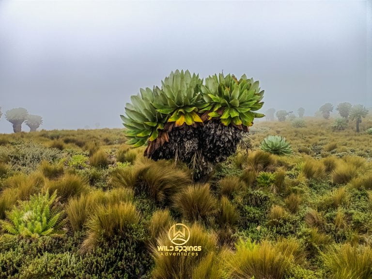
Open Afro-alpine moorland. Tussock grass, Giant Lobelia, Giant Senecio (Dendrosenecio battiscombei), Helichrysum everlasting flowers, Giant Heather. The Dragon's Teeth volcanic formations rising from the bog.
🌼 Zone 2 · Central Moorland · 3,200m–3,817m · Days 2–3
Table Mountain plateau and Seven Ponds basin. Hagenia abyssinica in sheltered glade sections. Protea (Protea kilimandscharica) growing naturally. The wildflower glade below Table Mountain's eastern face.
🌲 Zone 3 · Hagenia Forest · 3,000m–3,200m · Days 3–4
Ancient African Redwood trees on the Rurimeria descent and the Chania River valley. Gnarled, lichen-draped, the most atmospherically beautiful section of the traverse.
🎋 Zone 4 · Bamboo Jungle · 2,500m–3,000m · Days 5–6
Dense Yushania alpina bamboo on the Mutubio-Kinangop section and the Elephant Hill descent. Maximum wildlife activity. Elephant highways as navigation.
🌲 Zone 5 · Indigenous Montane Forest · 2,500m–2,800m · Day 6 Descent
Cedar, camphor, podocarpus. The forest the Mau Mau knew as operational territory, and the Elephant Hill trail descends through to Njabini Gate.
🦁 Wildlife Across the Traverse
Aberdare National Park is a designated Important Bird Area with 290+ bird species and some of East Africa's most significant forest mammal populations.
| 🐾 Species | 👁️ Likelihood | 📅 Most Likely Day |
|---|---|---|
| 🐘 Forest Elephant | ★★★★★ | Days 5–6 — the bamboo trails ARE their trails |
| 🦬 Cape Buffalo | ★★★★☆ | Days 4–6 — moorland and salient |
| 🦌 Mountain Reedbuck | ★★★★☆ | Days 2–3 — northern moorland |
| 🦌 Eland | ★★★☆☆ | Days 2–3 — open moorland sections |
| 🐒 Black-and-White Colobus | ★★★★☆ | Days 4–5 — Hagenia and Mutubio forest |
| 🐗 Giant Forest Hog | ★★★☆☆ | Days 4–5 — salient forest glades |
| 🦌 Mountain Bongo | ★★☆☆☆ | Day 5 bamboo — one of the last wild populations |
| 🐆 Leopard | ★★☆☆☆ | Days 5–6 — rocky forest near Kinangop |
| 🦏 Black Rhino | ★☆☆☆☆ | Salient zone — present, rarely seen on foot |
🔭 Birding: Aberdare Cisticola across moorland · Jackson's Francolin in heather zones · Hartlaub's Turaco in Hagenia forest · African Crowned Eagle above plateau cliffs · Scarlet-tufted Malachite Sunbird on Giant Lobelia. Log sightings at the Aberdare eBird hotspot.
👥 Who This Traverse Is For
🏋️ Serious hikers with multi-day experience.
You have completed at least two Aberdare day hikes above 3,500m. You know how altitude feels. You have camped in cold, exposed conditions before.
⚔️ Military personnel seeking to challenge themselves again.
The traverse's structure — accumulated days, varied terrain, bamboo navigation, high-altitude camp, early departures under pressure, and the constant pace required on Day 5 — provides a genuine test for people whose professional training built a baseline that civilian hiking rarely matches. This is the trek that gives that training something to answer. The sense of achievement at Njabini Gate on the final afternoon, for someone who has served, is comparable to none.
🏔️ Mountaineers building toward larger objectives.
Mount Kenya. Kilimanjaro. The Alps or Andes at some future point. The traverse builds multi-day altitude tolerance and self-management under sustained effort that no number of day hikes replicates in the same way.
📸 Expedition photographers.
Five habitat zones. Genuine wilderness light. Wildlife encounters that cannot be manufactured from a vehicle.
💼 Corporate and institutional teams.
Resilience and leadership built across multiple days in one of Africa's most complete wilderness environments, with a clear narrative arc: start at Shamata, finish at Njabini, earn every kilometre between.
❌ Not for: First-time hikers · Anyone who cannot confirm recent altitude experience · Hikers unable to carry a 35–40L daypack for 9 hours · Groups where any single member cannot honestly confirm fitness and commitment for every day.
📊 Complete Aberdares Comparison — All Peaks + All Traverses
Single-Day Peaks
| 🏔️ Peak | ⬆️ Summit | 📏 Dist | 💪 Difficulty | ⏱️ Time | 🎯 Highlight |
|---|---|---|---|---|---|
| 🌿 Mount Kipipiri | 3,349m | ~16km | Moderate | 8–9 hrs | Happy Valley views, wildflowers |
| 🐘 Elephant Hill | 3,658m | ~18km | Hard | 7–8 hrs | Most popular Aberdare day hike |
| 🪨 12 Apostles | 3,672m | ~32km | Very Hard | 12–17 hrs | Kenya's hardest single-day hike |
| 🗻 Table Mountain | 3,817m | ~11km | Hard | 7–9 hrs | Wildflower glade, flat plateau |
| 💧 Seven Ponds | 3,826m | ~14km | Hard | 7–10 hrs | Glacial tarns, photography |
| 🌾 Rurimeria Hill | 3,860m | ~15km | Strenuous | 7–10 hrs | Mount Kenya prep hike |
| 🦏 Rhino Hill | ~3,890m | ~17km | Hard | 7–9 hrs | Guide-named, off-trail summit |
| ⛰️ Mount Kinangop | 3,906m | ~24km | Hard–Very Hard | 9–12 hrs | Second-highest Aberdare, technical |
| 🐉 Satima Dragon's Teeth | 4,001m | ~16km | Moderate | 5–8 hrs | Best scenery per km in Kenya |
| 🌾 Satima Wandare Route | 4,001m | ~21km | Hard | 7–9 hrs | Harder, more direct Satima approach |
Multi-Day Traverses
| 🏔️ Traverse | ⛺ Duration | 📏 Dist | 💪 Difficulty | 🏔️ Summits | 💡 What Makes It |
|---|---|---|---|---|---|
| 🔷 N Moorland Short Traverse | 2–3D/1–2N | ~38km | Very Hard | Dragon's Teeth · Satima · Rhino Hill · Table Mountain · Seven Ponds · Rurimeria | Northern moorland only. Concentrated intensity. Very fit hikers. |
| 🔶 Southern Traverse — Mutubio | 3D/2N | ~40km | Expedition | Waterfalls · Kinangop · 12 Apostles (opt) · Elephant Hill | Pure southern jungle. Double logistics. Most expensive per km. Super-fit only. |
| 🏔️ Full N–S Traverse — 5-Day (This) | 5D/4N | ~74km | Expedition | All of the above combined | The complete range. Hotel acclimatisation night + 3 camps + Kinangop high camp. |
| ⚡ Full N–S Traverse — 4-Day | 4D/3N | ~74km | Expedition+ | Same as 5-day | No hotel night. Direct 04:00 Nairobi departure. Elite-fit groups only. |
Source: Wild Springs guided records · AllTrails — Aberdare National Park
On the difference between day hikes and traverses: Day hikes return you to Nairobi the same evening. The traverses do not. Weather is not a forecast — it is your physical reality. Wildlife is not a sighting — it is the reason your ranger walks in front of you through the bamboo. The range's full character reveals itself only to people who stay inside it long enough to stop being day visitors. The cost reflects the infrastructure this requires. The experience exceeds any description of it.
💰 Pricing — 2026
All-inclusive: hotel Night 1, park fees all days, full camping equipment, all field meals, porter team, field chef, lead guide, armed KWS ranger, Mutubio resupply, both vehicle movements, emergency equipment.
| 👥 Group Size | 🇰🇪 Kenyan Citizens | 🌍 EA Residents | 🌐 International |
|---|---|---|---|
| 2 persons | KES 98,000 pp | KES 118,000 pp | USD 1,500 pp |
| 3 persons | KES 85,000 pp | KES 103,000 pp | USD 1,320 pp |
| 4 persons | KES 75,000 pp | KES 91,000 pp | USD 1,180 pp |
| 5 persons | KES 68,000 pp | KES 82,000 pp | USD 1,080 pp |
| 6 persons | KES 62,000 pp | KES 76,000 pp | USD 1,000 pp |
| 7–10 persons | KES 58,000 pp | KES 70,000 pp | USD 920 pp |
⚡ 4-Day version: Deduct KES 3,500 / USD 45 pp (no hotel night) 🔥 12 Apostles extension (Option B, Day 6): +KES 5,000 / USD 65 pp — pre-book only
📅 Deposit: 40% on confirmation of booking 💳 Balance: 14 days before departure
🚫 Cancellation policy:
- 14+ days before: 100% refund of balance
- 7–13 days before: 50% of total charged
- Under 7 days: 100% of total charged
- No show: 100% charged
✅ Inclusions
- 🏨 1 night Juniper Green Gardens Resort, Mweiga — twin-share, dinner and breakfast included
- 🚐 Return transport: Nairobi → Mweiga (Day 1) · Mweiga → Shamata/Rhino Gate (Day 2) · Njabini Gate → Nairobi (Day 6)
- 🏞️ Aberdare National Park entry and vehicle fees for all trekking days (Days 2–6)
- ⛺ 4 nights field camping — expedition-grade tents (2-person), sleeping bags rated −5°C, sleeping mats
- 🍽️ Full board all field days: packed lunches and dinners from Day 2 · breakfast through Day 6
- ☕ Hot beverages every morning and evening at all camps
- 🎒 Porter team — 1 porter per 2 trekkers for all camping equipment
- 👨🍳 Field chef for all camp meals
- 🔄 Mid-traverse resupply at Mutubio Camp (Day 4) — fresh food and water
- 🧭 Traverse-experienced Wild Springs lead guide — all days
- 🪖 Armed KWS ranger — all trekking days (Days 2–6)
- 💧 Purified camp water at all camp nights
- 🩺 Comprehensive first aid kit and emergency evacuation coordination
- 📡 Emergency satellite communication device
❌ Exclusions
- 👟 Personal hiking gear — waterproof boots, SFS-rated gaiters, trekking poles, warm and waterproof layers, headlamp and spare batteries
- 🛡️ Mountain rescue and medical evacuation insurance — required before departure. Minimum cover: KES 60,000 / USD 450
- 🏕️ Sleeping bag liner — strongly recommended for Kinangop high camp night
- 🙏 Gratuities for crew — suggested per day: Lead guide KES 1,500 · Porter KES 500 · Chef KES 800 · Ranger KES 500
- 🍺 Alcoholic beverages at Juniper Resort or in the field
- 🛏️ Single room supplement at Juniper Green Gardens — KES 2,500 per night
- 📷 Professional photography service (available on request)
- ✈️ Flights to Kenya and Kenyan visa fees where applicable
- 💊 Personal medication and medical supplies beyond the group first aid kit
💳 How to Book & Pay
Step 1 · Pre-Booking Consultation — required before any booking is confirmed. Our lead guide will speak with you directly about your recent hike history, fitness level, and gear situation. This is a two-way conversation. If the traverse is the right fit for your group, we confirm. If it is not, we recommend the right alternative and tell you honestly why.
Step 2 · Gear Check Appointment — confirmed bookings receive a gear check appointment 7–14 days before departure. We inspect boots, gaiters, sleeping bag, insulation layers, and pack. We will help source any missing or inadequate items. This appointment is mandatory. Your safety is our greatest concern.
Step 3 · Deposit — 50% of Total
📱 M-Pesa Paybill
- Paybill Number: 4065921
- Account: Your full name + "NS Traverse"
- After payment: WhatsApp proof of payment, your name, departure date, group size, and pickup location to the booking number below
Step 4 · Balance — 60%, due 14 days before departure. By M-Pesa (same Paybill) or cash at the office.
🏢 Office — Walk-ins Welcome for Consultations
Valley View Office Park, Tower A, First Floor Sixth Avenue Parklands, off Limuru Road, Nairobi
📞 +254 729 257 317 📞 +254 734 417 496 📞 +254 721 957 652
📧 [email protected] 📧 [email protected]
📬 Contact & Full Enquiry Form | 🌐 wildsprings.co.ke | 🏪 Gear Store
🌿 The Range Runs North to South
It always has. Long before the gates were named and the maps were printed and the trails were marked, the Kikuyu called this ridge Nyandarua — the drying hide — for the way it stretched across their horizon, a shape they could name by sight from anywhere in the central highlands. The same ridge. The same mountains. The same moorland connecting them, north to south, from the bull mountain at Satima to the elephant's hill above Njabini.
Nobody crosses the full range as one unbroken journey.
Until you do.
The sense of achievement at Njabini Gate on the final afternoon is comparable to none.
Where You Will Visit
This safari explores the following regions in Kenya
- Aberdares