🗻 Table Mountain Northern Aberdare Range · 3,791 Metres— The Flat Summit That Hides Its Best Views
Safari at a Glance
Wild Springs Adventures | 📍 Kwa Matu Electric Fence Gate · Nyandarua County · Kwa Matu · Northern Aberdare Range · 3,791 Metres
🏔️ The Mountain That Saves Its Best for Last
Most Aberdare trails are honest about what they are. Rurimeria is steep from the start and stays steep. Elephant Hill is hard, and everyone agrees. Kinangop is the mountain that takes a full day of suffering before you reach it. The 12 Apostles will tell you upfront what it plans to do to you.
Table Mountain plays a different game. It deceives you, then reveals itself in stages — and each reveal is better than the last.
It starts by making you go down. The only Aberdare trail in the range that opens with a descent — a steep drop to a river crossing before a single metre of upward progress. Then, the moment you cross that river and step through the electric fence, it unleashes the hardest kilometre on any northern Aberdare trail: a near-vertical wall of montane forest that demands hands, knees, and honesty about your fitness level. The stinging nettles are part of the welcome.
Then — just when you have earned the right to be disillusioned — the forest opens onto a wildflower glade. A flat, grassy clearing ringed by Hagenia abyssinica (African Redwood) trees, filled with colour: wildflowers in every direction, bees moving between blooms, the Wanjohi Valley spread wide and green below you, and Mount Kipipiri's isolated cone visible across the valley like a landmark from another age. Happy Valley. The infamous 1920s playground of British colonial hedonism — Lady Idina Sackville's wild parties, the aristocrats, the wife-swapping, the scandal that made the world joke "Are you married or do you live in Kenya?" — all of it set in the valley below your boots right now. The mountain gives you this view at the exact moment you need a reason to continue.
Then the rock gallery. Then the moorland. Then the plateau.
And then — only then — the thing no photograph or description quite prepares you for: standing at the edge of the Table Mountain plateau and looking down over a cliff face that was completely invisible until you were five steps away. Deep valleys and plunging moorland cliffs falling hundreds of metres below. Lake Ol Bolosat shimmering to the northwest. Satima to the north. Rurimeria to the east. Kipipiri across the valley to the west. The whole northern Aberdare range in one panoramic frame from a summit you can walk around.
Table Mountain is the only Aberdare peak with a flat summit plateau. Every other summit in the range ends at a point or a ridge. Table Mountain ends at a table — and that changes everything about what you do when you get there.
🎯 The honest truth:
Table Mountain is neither the tallest nor the hardest trail in the Aberdares, which is precisely why it is underrated by people who sort trails by summit elevation. The wildflower glade section is the most beautiful mid-trail moment on any northern Aberdare hike. The plateau cliff discovery is a genuinely surprising experience that no amount of reading about it prepares you for. And the trail's structural honesty — brutal early, extraordinary later — means you earn every view through effort, then spend unhurried time on a flat summit exploring what appears around each corner. That is a rare thing on any mountain.
📋 Table Mountain Aberdare Range Trek at a Glance
| 🗻 Summit | Table Mountain (Aberdares), 3,791m (12,438 feet ) |
| 📈 Elevation Gain | ~1,000–1,100m from Kwa Matu gate |
| 📏 Distance | ~11–12km round trip |
| ⏱️ Time on Trail | 7–9 hours |
| 📍 Trailhead | KWS Electric Fence Gate, Kwa Matu, Nyandarua County |
| 🗓️ Trailhead Altitude | 2,770m (9,088ft) |
| 💪 Difficulty | Hard — brutal opening ascent, high altitude, boggy plateau |
| 🛣️ Distance from Nairobi | ~155km (approx. 2.5–3 hrs drive) |
| 🪖 Guide Requirement | Armed KWS ranger + certified guide — mandatory |
| 🌼 Signature Features | Wildflower glade · Rock sculpture gallery · Flat plateau · Hidden cliff views |
| 👁️ Summit Views | Satima · Rurimeria · Kipipiri · Lake Ol Bolosat · Wanjohi Valley |
| 🎭 Shared Trailhead With | Seven Ponds trail — goes right at the gate; Table Mountain goes left |
🌼 Why Table Mountain Is Unlike Any Other Aberdare Trail
Every other peak in the Aberdare range rewards you with a summit point — a rocky high spot, a narrow ridge crest, a cairn. You arrive, you photograph, you descend. Table Mountain is different in a way that changes how you experience the summit entirely.
The plateau at 3,817m is genuinely flat. Not "relatively flat" — actually, walkable, explorable flat. When you arrive, you are not standing at the edge of something. You are standing on something. And when you start walking across it, the plateau reveals itself one cliff edge at a time.
Walk north: Satima appears, enormous and snow-capped in the clear season, with the moorland ridge between you laid out like a geography lesson.
Walk west: The cliff. Completely invisible from the trail side, it appears in three steps — you are walking across flat moorland, then there is a lip, then there is nothing for hundreds of metres. Deep valleys and plunging Aberdare moorland cliffs that were hidden from every other angle. Lake Ol Bolosat catches the light to the northwest — Kenya's only natural freshwater lake on the central plateau, looking from up here like something a god placed there for scale.
Walk south: The Seven Ponds moorland visible in the middle distance. Rurimeria's summit to the southeast.
Walk east: Kipipiri across the Wanjohi Valley — the butterfly mountain, its twin summit profile clear from this angle in a way it never is from below.
The plateau also has ponds and marshes on its surface — small moorland tarns that appear between tussock clumps when you move away from the summit marker and explore the interior. This is the Aberdares' best-kept summit secret: a mountain with things to discover after you summit it, not just at the moment of arrival.
Take a minimum of 30 minutes on the plateau. Walk to at least two cliff edges. Look both ways. The mountain will show you things that no advance description can prepare you for.
🕐 The Full Day Table Mountain Aberdare itinerary — Hour by Hour
🚐 04:30 · Nairobi · Departure
The drive northwest follows the Nakuru highway, branches at Flyover, through Njabini and Engineer to the KWS office at Ndunyu Njeru, then onward to Kwa Matu. About 155km — 2.5 to 3 hours. The road through Wanjohi Valley in the morning light is already worth something: farmland, forest edges, and ahead of you, the Aberdare ridgeline beginning to show itself above the clouds. Park entry fees are paid at the KWS office at Ndunyu Njeru before proceeding to the trailhead.
📋 08:00 – 08:30 · Kwa Matu Electric Fence Gate, 2,770m · Briefing & Start
The armed ranger collected. Your guide briefs the group — including the one detail that distinguishes this trail from every other Aberdare start: the hike opens with a descent. Down to the river. Through the electric fence. Then up. The trail shares the same gate with the Seven Ponds trail, which branches right almost immediately. Table Mountain goes left. They are neighbours at the start and separate into completely different mountains within the first 200 metres.
⬇️ 08:30 – 08:45 · The River Crossing
A short descent from the gate to a stream crossing at the valley floor. Cool water, stepping stones, the electric fence gate on the far bank. This is the warm-up. It does not feel like a warm-up. It feels like a trap — because what comes next is the hardest section of the entire trail.
⛰️ 08:45 – 10:30 · 2,770m – 3,200m · The Near-Vertical Kilometre
Past the fence, the trail immediately begins a near-vertical ascent through dense montane forest. This is the section that earns the trail its reputation for not being beginner-friendly. The gradient is brutal and sustained — close to vertical in sections, requiring hands-on roots and rocks. Stinging nettles (Urtica dioica) line the trail edges and catch anyone who drifts off the path. The forest is enclosed, there is no view, and the effort is relentless.
This is the Table Mountain trial by fire. It lasts approximately 1 kilometre of vertical gain and 60 to 90 minutes of effort. By the top of it, every member of the group has been honest with themselves about their fitness.
⚠️ This section is the reason Table Mountain is not a beginner trail despite its moderate-looking summit elevation. The gradient in the opening kilometre above the river rivals anything on Rurimeria. Slow, deliberate footwork and patience are the correct response. Going fast here costs everything later.
🌼 10:30 – 11:00 · ~3,200m · The Wildflower Glade — The Most Surprising Moment on Any Aberdare Trail
The forest breaks. The world opens.
You step from the dark, steep montane forest into a wide, flat clearing — an alpine meadow at 3,200m ringed by Hagenia abyssinica (African Redwood) trees, filled with wildflowers in every direction. Helichrysum in gold and cream. Lady's Mantle with silver dew on its leaves. Indigenous flowering herbs and grasses that produce pollen thick enough to notice on your jacket. At the far end of the glade, a grove of Hagenia trees frames a stream crossing — and through the trees, the Wanjohi Valley lies spread open below.
This is the moment to stop and look down.
The valley below is the Wanjohi Valley — known to history as Happy Valley, the 1920s–1930s headquarters of British colonial hedonism, where aristocrats and wealthy settlers threw legendary parties, reinvented their moral codes, and generated enough scandal to fill multiple books and a murder trial. The Wanjohi River runs through it. Mount Kipipiri rises across the valley. The settled farmland of Nyandarua County stretches south. From this altitude, it is beautiful, peaceful, and very quiet — and yet everything that happened in that valley has been written about for a century.
The Protea also grows here — an extraordinary botanical detail. The Protea (Protea kilimandscharica) — the national flower of South Africa, found here growing naturally at high altitude in the Kenyan highlands. It appears at the edge of the glade near the Hagenia grove, a white-flowered shrub with the distinctive star-burst flower head, growing exactly where it has grown since before anyone named it a national flower of anything.
Eat something here. Drink water. Look at the valley. Then continue.
🪨 11:00 – 12:30 · 3,200m – 3,600m · The Rock Gallery & Upper Ascent
Past the glade and the stream crossing, the trail turns rocky and steep again — but this time with drama. As the path skirts around the base of the upper summit cliffs, volcanic rock formations rise on the left: an outdoor gallery of rock sculptures, as one hiker described them, each formation different in shape and texture, each one stopping your eye as you climb. The views of the Wanjohi Valley below, framed by the rock formations, are the best photographic compositions on this trail.
The trail ascends through a second steep section here — less brutal than the river wall below, but notable — before the gradient eases as the moorland begins and the summit plateau edge comes into view above.
🌾 12:30 – 13:30 · 3,600m – 3,817m · The Moorland & Summit Approach
The final section crosses the upper moorland to the plateau edge. Tussock grass and giant heather. The last boggy sections before the flat summit. Then a final short scramble up the lip of the plateau — and you are on top.
🏆 13:30 · 3,817m · TABLE MOUNTAIN — THE SUMMIT PLATEAU
The summit marker. But do not stop here. Walk north. Walk west. Walk to the cliff edges. The mountain has been hiding its views from you all morning, and it will keep hiding them until you walk to the right position.
What you will find: Satima (4,001m) filling the northern horizon. The Seven Ponds moorland is visible to the east with Rurimeria beyond it. The Wanjohi Valley — the full Happy Valley landscape — far below to the west with Kipipiri rising from it. The plateau's own internal ponds and marshy sections appearing between tussock clumps. And the cliff edges — the most dramatic surprise on any Aberdare summit — where the flat plateau drops away into deep, plunging valleys that were invisible from every angle of the ascent.
Eat your summit lunch here, sitting at whichever cliff edge faces the view that speaks most to you.
15:00 — mandatory descent start.
⬇️ 15:00 – 17:00 · 3,817m → 2,770m · Descent
The descent retraces the ascent in reverse. The rocky gallery section descends more gently than it ascended. The wildflower glade is softer in the afternoon light, the valley below beginning to cast a shadow. The near-vertical forest section demands the most attention on descent — slippery and steep, poles essential, pace slow and controlled. The river crossing at the bottom is a relief. Back through the gate by 17:00. Nairobi by 20:00.
🗺️ The Five Trail Sections Table Mountain Aberdare Trail
⬇️ Section 1 · The Descent & River Crossing · 2,770m → 2,750m
The only trail in the Aberdares that opens going downhill. Short, steep descent to a stream. Through the electric fence. The deceptive warm-up that the trail uses before delivering the real first section.
⛰️ Section 2 · The Near-Vertical Kilometre · 2,750m – 3,200m
The hardest kilometre of hiking on the northern Aberdares. Dense forest, near-vertical gradient, stinging nettles, no views. The section that decides who should be on this trail and who should try again after more preparation. 60–90 minutes of sustained effort.
🌼 Section 3 · The Wildflower Glade · ~3,200m
The trail's defining moment. An open alpine meadow with wildflowers, Hagenia trees, a stream crossing, Protea growing naturally, and the Wanjohi Valley laid out below with Mount Kipipiri across it. The most beautiful rest point on any northern Aberdare trail. Do not rush through this section.
🪨 Section 4 · The Rock Gallery & Upper Ascent · 3,200m – 3,600m
Volcanic rock formations as the trail skirts around the summit cliffs. The best photographic compositions of the Wanjohi Valley. A second steep section before the moorland begins and the gradient eases.
🏅 Section 5 · Moorland, Plateau Edge & Summit · 3,600m – 3,817m
The flat plateau with its hidden cliff views, ponds, and 360° moorland panorama. Satima north, Kipipiri west, Seven Ponds and Rurimeria east, Lake Ol Bolosat northwest, deep plunging valleys below the plateau edge. The summit that gives you space to explore rather than just a point to touch.
🌿 Flora along Table Mountain Aberdare Trail
Table Mountain's trail passes through more distinct vegetation communities per kilometre than any other northern Aberdare trail — from dense montane forest, through an extraordinary wildflower glade, into rocky heather sections, and finally the open Afro-alpine moorland plateau.
The wildflower glade at 3,200m is the trail's botanical highlight and has no equivalent on any other Aberdare trail. Hagenia abyssinica (African Redwood) trees frame the clearing, their gnarled orange-red bark and fern-draped branches the signature tree of the Afro-montane zone. Within the glade, Helichrysum spp. (everlasting flowers — an Aberdare endemic form) grows in gold and cream drifts. Lady's Mantle (Alchemilla hageniae) fills the wetter channels. And the Protea (Protea kilimandscharica) — the flower that became the national flower of South Africa, yet grows naturally across East Africa's highland zones — flowers in the glade's margins with its distinctive white star-burst head.
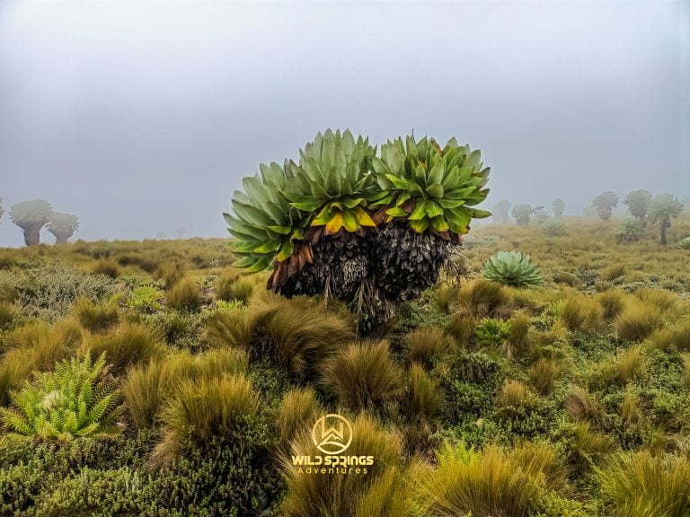
On the upper moorland and plateau, Giant Lobelia (Lobelia deckenii) and Giant Senecio (Dendrosenecio battiscombei) stand on exposed ridges and plateau edges — the ancient-looking Afro-alpine plants found only at the highest elevations of East Africa's mountains. The plateau's own marshy sections support tussock grass (Deschampsia spp.) and Giant Heather (Erica arborea). The Aberdare Range holds 778 recorded plant species — this trail samples more of their altitudinal diversity than almost any other single-day Aberdare hike.
🦁 Wildlife & Nature, you may see Table Mountain Aberdare Trail
Table Mountain sits within Aberdare National Park, a designated Important Bird Area (IBA) recording over 290 bird species and some of Kenya's most significant large mammal populations.
| 🐾 Species | 👁️ Likelihood | 📍 Where | 📝 Note |
|---|---|---|---|
| 🐘 Forest Elephant | ★★★★☆ | Lower forest & electric fence sections | Active along the fence line — one of the more reliable elephant encounter zones on the northern trails |
| 🦬 Buffalo | ★★★☆☆ | Forest & rock gallery sections | Groups regularly move through the forest belt between the river and the glade |
| 🦌 Mountain Reedbuck | ★★★★☆ | Wildflower glade & upper moorland | Often grazing in the glade clearing — remarkably calm at distance |
| 🐒 Black-and-White Colobus | ★★★★☆ | Montane forest section | Reliable in the dense forest above the river crossing |
| 🦁 Serval Cat | ★★☆☆☆ | Upper moorland & plateau | The Table Mountain plateau is good habitat — rarely seen but present |
| 🦌 Eland | ★★★☆☆ | Upper moorland near plateau | Africa's largest antelope occasionally grazes the plateau edges |
| 🦏 Black Rhino | ★☆☆☆☆ | Park Salient | Present in the broader ecosystem; a plateau sighting would be extraordinary |
🔭 Birding at Table Mountain Aberdare
The five distinct habitat zones of this trail — montane forest, wildflower glade, Hagenia forest edge, rocky heather section, and open moorland plateau — give birders five separate communities in one day. The wildflower glade in particular, with its mix of Hagenia canopy, open flowering meadow, and stream, is a genuinely rich bird habitat that most Aberdare trails do not pass through.
- Aberdare Cisticola (Cisticola aberdare) — Kenya's true highland endemic. The tussock moorland on the plateau and upper trail sections are core habitat.
- Jackson's Francolin (Pternistis jacksoni) — near-endemic; reliably heard in the heather transition zones above the glade.
- Hartlaub's Turaco — brilliant crimson wings in the montane forest section. The most dramatically coloured bird on the trail, heard before seen from the dense canopy.
- African Crowned Eagle — nests in the Aberdare forest. Occasionally seen soaring above the cliff edges on the plateau.
- Scarlet-tufted Malachite Sunbird — follows the Giant Lobelia flowering cycle on the upper moorland.
- Moorland Chat — conspicuous on the plateau rocks.
- African Stonechat — perches on every exposed branch from the glade upward.
- Mountain Buzzard — soars above the plateau on morning thermals; impressive from below the cliff edges looking up.
Log your sightings at the Aberdare National Park eBird hotspot.
💰 Table Mountain Aberdare Trek Pricing — 2026
All costs complete. No surprises at the KWS office or the gate.
| 🇰🇪 Kenyan Citizens | 🌍 East African Residents | 🌐 International |
|---|---|---|
| KES 4,999 per person | KES 5,700 per person | USD 99 per person |
Group discounts apply for 5+ people. Contact us for a private group quote.
✅ What's Included
- 🚐 Round-trip transport from Nairobi (CBD/Westlands pickup)
- 🏞️ Aberdare National Park entry fees (KWS)
- 🪖 Mandatory armed KWS ranger for the full day
- 🧭 Certified Wild Springs mountain guide
- 🍱 Packed lunch and trail snacks
- 💧 Drinking water
- 🩺 Emergency first aid kit and evacuation support
❌ Not Included
- 👟 Personal hiking gear: waterproof boots, gaiters, warm layers
- 🙏 Guide & ranger tips (KES 1,000–2,000 suggested)
- 🛡️ Travel insurance (strongly recommended)
- ➕ Traverse extension to Seven Ponds (see below)
➕ Table Mountain Aberdare Trek Traverse Options — Complete the Northern Ridge
Table Mountain's shared trailhead with Seven Ponds creates a natural traverse pairing — two summits, one long ridge, one extraordinary day.
🌊 Table Mountain + Seven Ponds Traverse
Ascend Table Mountain, cross the northern moorland ridge to the Seven Ponds plateau (3,826m), and descend via the Seven Ponds trail. Two summits, two completely different summit experiences — the explorable flat plateau of Table Mountain and the glacial tarn field of Seven Ponds — linked by a moorland ridge walk above 3,600m. Adds 3–4 hours and requires a pre-planned route.
🦏 Rurimeria → Rhino Hill → Table Mountain (Epic Three-Summit Traverse)
Ascend Rurimeria, cross via Rhino Hill, descend via Table Mountain. The most complete northern Aberdare ridge day available. Elite hikers only. Contact us before considering this option.
Contact Wild Springs to arrange traverse logistics — all traverse options are private bookings.
⚠️ Safety on This Trail
⚠️ The Opening Kilometre Is the Hardest on Any Northern Aberdare Trail
The near-vertical forest ascent above the river crossing catches every group that underestimates it. The stinging nettles are real. The gradient is real. The muddy, root-tangled surface after rain is real. Long trousers, waterproof boots with ankle support, and patience are the correct response. Do not go fast in this section — it costs everything later.
⚠️ Plateau Cliff Edges — No Fencing, No Warning
The cliff edges that reveal themselves as you walk around the summit plateau have no barriers, no signs, and no warning before they appear. The trail from below gives no indication of how dramatic the drop is. Walk carefully when approaching any edge you have not yet reached. Keep children and groups close.
⚠️ Slippery Descent
The steep sections above the river are particularly slippery on the way down, especially after rain. Multiple experienced hikers describe the descent as genuinely slow and technical. Trekking poles are critical. No rushing.
⚠️ Boggy Plateau
The summit plateau has marshy sections between the tussock clumps. Gaiters prevent the worst of it. Walk on the tussock grass, not between the clumps.
⚠️ Altitude Above 3,500m
Standard high-altitude protocol applies: slow and steady pace, 3 litres of water, immediate descent if symptoms worsen. The near-vertical opening section at a lower altitude can exhaust hikers who then face the altitude effects above 3,500m with depleted reserves.
⚠️ Pollen
The wildflower glade at 3,200m produces significant pollen during the flowering season (short rains and early dry season). Hikers with hay fever or pollen sensitivity should carry an antihistamine.
🎒 What to Bring Table Mountain Aberdare Hk
🥾 Footwear & Lower Body
- Waterproof hiking boots with ankle support — the root-tangled forest section and boggy plateau both demand them
- Gaiters — for the plateau marsh sections and the stinging nettles
- Long trousers — non-negotiable. The stinging nettles in the opening forest section make bare legs a genuinely painful mistake
- Two hiking sock pairs
🧥 Clothing Layers
- Moisture-wicking base layer — no cotton
- Insulating mid-layer — fleece or lightweight down
- Waterproof, windproof shell — the plateau is exposed and cold
- Warm hat and gloves — particularly important on the plateau where the wind has no obstacles
- Sun hat — the wildflower glade and upper moorland have no canopy
🎒 Gear & Food
- Trekking poles — essential for the steep descent; the near-vertical forest section is where they pay for themselves
- 3 litres of water minimum
- Packed lunch eaten at the plateau — plan to stay 30 minutes exploring before eating
- Camera with a fully charged battery — the wildflower glade, the rock gallery, and the cliff-edge views all reward photographs
- Antihistamine for pollen-sensitive hikers
- Sunscreen SPF 50+
- Personal first aid: blister pads, paracetamol, personal medication
🏪 Everything you need at the Wild Springs Outdoor Store. Ask specifically about gaiters — the combination of stinging nettles and plateau bog makes them essential on this specific trail.
📅 When to Go Table Mountain Aberdare Hk
Table Mountain's wildflower glade is at its most vivid during and just after the short rains (October–December) — the bloom is exceptional and the pollen is thick. Dry season gives firm trails and clear summit views.
| 📆 Month | ⭐ Conditions |
|---|---|
| January | ⭐⭐⭐⭐⭐ Ideal — firm trail, clear views, dry plateau |
| February | ⭐⭐⭐⭐⭐ Ideal — best summit visibility of the year |
| March | ⭐⭐⭐ Okay — early rains, trail gets muddier |
| April | ⭐ Avoid — long rains, near-vertical section becomes extremely hazardous |
| May | ⭐ Avoid — worst conditions; descent dangerous when wet |
| June | ⭐⭐⭐⭐ Good — dry season, firm trail |
| July | ⭐⭐⭐⭐⭐ Ideal |
| August | ⭐⭐⭐⭐⭐ Ideal |
| September | ⭐⭐⭐⭐ Good |
| October | ⭐⭐⭐ Variable — short rains begin; wildflower glade at peak bloom but trail wets up |
| November | ⭐⭐⭐ Wildflower season — extraordinary glade colours, slippery trail |
| December | ⭐⭐⭐⭐ Good — rains ease, glade still flowering |
📊 How Table Mountain Compares to Aberdare Trails
| 🏔️ Trail | ⬆️ Summit | 💪 Difficulty | 🎯 Best For | ⏱️ Time |
|---|---|---|---|---|
| 🌿 Mount Kipipiri | 3,349m | Moderate | Wildflowers, Happy Valley history | 8–9 hrs |
| 🐘 Elephant Hill | 3,658m | Hard | First serious Aberdare challenge | 7–10 hrs |
| 🪨 12 Apostles | 3,672m | Very Hard | Kenya's toughest day hike | 12–17 hrs |
| 🗻 Table Mountain | 3,817m | Hard | Wildflower glade · Flat explorable plateau · Hidden cliff views · Happy Valley panorama | 7–9 hrs |
| 💧 Seven Ponds | 3,826m | Hard | Glacial tarns, photography, solitude | 7–10 hrs |
| 🦏 Rhino Hill | ~3,890m | Hard | Off-trail wilderness | 7–9 hrs |
| 🌾 Rurimeria Hill | 3,860m | Strenuous | Mount Kenya training | 7–10 hrs |
| ⛰️ Kinangop | 3,906m | Hard–Very Hard | Technical summit, ridge views | 9–12 hrs |
| 🏅 Satima | 4,001m | Moderate–Hard | Highest Aberdare, Dragon's Teeth | 5–8 hrs |
Table Mountain is the only Aberdare summit you can walk around after arriving. Every other peak ends at a point. This one ends at a plateau — and the plateau is worth more time than most hikers give it.
Source: AllTrails — Aberdare National Park · Wild Springs guided records.
👥 Private & Custom Options for Table Mountain Aberdare Trek
👥 Private Groups
Table Mountain on private booking means your own pace through the wildflower glade — the section most group hikers rush through because they are managing a crowd. A private booking is the right format for photographers, botanists, and anyone who wants to actually sit in the glade and look at the Wanjohi Valley for ten minutes without a group moving around them.
📸 Photography Groups
Three distinct photographic compositions in one trail: the wildflower glade with the valley below and Kipipiri as a backdrop; the rock gallery with Wanjohi Valley framing; and the cliff-edge plateau views with the full northern Aberdare panorama. Custom pacing and extended time at each section available for photography-focused groups on request.
🏢 Corporate Teams
Table Mountain's structure — brutal opening, beautiful middle, rewarding summit — mirrors a well-run organisation project. The wildflower glade is where people stop, look, and understand why they came. The plateau is where the full picture reveals itself. This is an excellent format for teams that have already done a beginner hike together and want the next level.
🌊 Seven Ponds Traverse Combo
The most popular traverse on the northern Aberdare ridge for groups that want two distinct summit experiences in one day. Pre-booking required. Contact us for full traverse logistics and pricing.
🤝 Why Wild Springs is the best for Table Mountain Aberdare Trek
- ⭐ TripAdvisor Award Winner — verified reviews from real hikers
- 🏛️ Kenya Tourism Authority Licensed — fully registered tour operator-TRA1/47/C01/25895
- 🌍 TOSK Kenya Member — Tour Operators Society of Kenya
- 🧗 KS Certified Guides — Mountain Club of Kenya; our Table Mountain guides know the wildflower glade's seasonal state and the plateau cliff edges that first-timers approach dangerously
- 🤝 Fair Pay — guides and rangers paid above industry standard
- 🌿 Leave No Trace — zero plastic policy, all waste carried out
🏔️ What Comes Next
Table Mountain is a natural mid-range Aberdare objective — harder than Kipipiri, comparable to Seven Ponds, below Rurimeria and Kinangop in elevation.
- 💧 Seven Ponds Aberdares — the glacial tarn trail sharing your trailhead; traverse them both
- 🌾 Rurimeria Hill Moorland Trek — the serious Mount Kenya preparation hike, one ridge to the east
- 🦏 Rhino Hill Aberdares — the guide-named off-trail summit above Seven Ponds
- 📅 Mount Kenya Group Treks 2026 — the next mountain
- 💪 Mount Kenya Fitness Programme — 8-week training plan
- 🎒 Gear Checklist
- 🏪 Wild Springs Outdoor Store — gaiters, poles, and waterproof layers for this specific trail
💳 How to Book & Pay
📱 M-Pesa Paybill
- Paybill: 4065921
- Account: Your name + "Table Mountain"
After payment, WhatsApp your name, date, group size, and pickup location to confirm.
🏢 Cash at the Office
Valley View Office Park, Tower A, First Floor, Sixth Avenue Parklands, off Limuru Road, Nairobi
Table Mountain Contacts
📞 +254 729 257 317 · +254 734 417 496 · +254 721 957 652
📧 [email protected] · [email protected]
📬 Contact & Enquiries | 🌐 wildsprings.co.ke
🗻 The Flat Top Is Waiting
Six hours of earned altitude. A wildflower glade that most hikers do not know exists. A plateau where the views appear one cliff edge at a time. The full northern Aberdare range in a single panoramic frame. And the Wanjohi Valley below — a hundred years of history laid out at your feet.
The mountain has been setting you up for this all morning. Walk to every edge.
Where You Will Visit
This safari explores the following regions in Kenya
- Aberdares