🏔️ Mount Kenya Land Of Lakes And Tarns — 7-Day Expedition 2026
Safari at a Glance
Africa's Greatest Alpine Lake Trail · From 3,100m to 4,985m
Wild Springs Adventures · Nairobi-Based Mountain Specialists Since 2013
🏆 TripAdvisor Travelers' Choice 2024, 2025, and 2026· ✅ TRA Licensed No. TRA1/47/C01/25895 · 🏛️ TOSK Member #0082
Mount Kenya National Park · 7 Days / 6 Nights · 5 Lakes · 12+ Tarns · Point Lenana 4,985m Optional · From $780 Per Person
5 Things That Make This Expedition Different ⚡
1. Most Mount Kenya climbs pass two lakes — Lake Ellis and Lake Michaelson — on the way to the summit. This expedition makes the lakes and tarns the destination, not the backdrop. You will camp beside water every single night.
2. The route starts at Lake Rutundu (3,100m) — where Prince William proposed to Kate Middleton in 2010 — and ends at Lewis Tarn (4,800m), the highest accessible water body on the mountain. No competitor currently runs this full lake-to-lake traverse.
3. Mount Kenya has 31 named water bodies. This expedition visits 15 of them — 5 named lakes and 10 tarns — spread across four distinct route sections of the mountain.
4. The Hobley Valley on Day 5 is the most lake-dense zone on the mountain — Carr Lakes, Enchanted Lakes, Thompson Tarn, and Gallery Tarn all within 2km of each other. Very few climbing groups pass through this valley. You will have it almost entirely to yourselves.
5. Point Lenana (4,985m) is an optional addition on Day 6. If your group wants the summit, we plan the pre-dawn push. If the expedition is purely about the lakes, the High Tarns Circuit is the alternative — visiting Lewis Tarn, Harris Tarn, Square Tarn, and the Simba Tarns without the summit.
The Lake Argument - Why This Is the Best Version of Mount Kenya
Most people climb Mount Kenya for the summit. That is understandable. Point Lenana is a genuinely significant achievement and the pre-dawn push to the summit at 4,985m for the African sunrise is an experience that lands on people in ways they struggle to describe.
But the summit is not actually the most beautiful part of Mount Kenya.
Mount Kenya's lakes and tarns are. The mountain holds 31 named water bodies — 5 significant lakes and 26 tarns — distributed between 3,100m and 4,800m. They sit in glacially-carved valleys, shielded by 300-metre cliff faces, fed by retreating glaciers, stocked with rainbow and brown trout, reflecting the twin technical peaks of Batian and Nelion in conditions that — when the light is right — produce photographs that appear manipulated.
They are not manipulated. That is what these places actually look like.
The explorer Mackinder, who made the first ascent of Batian in 1899, named Lake Michaelson after a friend. He did so because the view of the lake in the Gorges Valley, shielded by The Temple cliff and fed by Vivienne Falls, was the most striking landscape he had encountered on the entire mountain. He had been to the summit. He still chose the lake.
This expedition follows the water.
🗺️ Complete Lake and Tarn Itinerary - Day by Day
📍 Altitude and Distance Overview
| Day | Route Section | Start | End | Altitude | Km | Hours |
|---|---|---|---|---|---|---|
| 1 | Nairobi → Rutundu Roadhead | 1,750m | 3,000m | +1,250m (drive) | Drive | — |
| 2 | Rutundu Loop | Lake Rutundu 3,100m | Lake Alice 3,550m return | +450m | ~14km | 5 to 6 |
| 3 | Rutundu → Chogoria via Hinde Valley | 3,000m | Lake Ellis 3,500m | +500m trekking | ~12km | 5 to 6 |
| 4 | Lake Ellis → Lake Michaelson | 3,500m | Lake Michaelson 3,950m | +450m | ~10km | 5 to 6 |
| 5 | Michaelson → Hobley Valley Tarns | 3,950m | Mintos/Halls Tarn 4,300m | +350m | ~12km | 6 to 7 |
| 6 | High Tarns Circuit or Summit | 4,300m | Point Lenana 4,985m or High Circuit | +685m | ~15-20km | 8 to 12 |
| 7 | Descent Sirimon → Nairobi | 4,200m | 1,750m | -2,450m | ~18km | 7 to 8 |
🚐 Day 1 — Nairobi to Rutundu Roadhead (3,000m): The Eastern Approach
Departure: 06:30 AM from Nairobi
The drive heads north and east. You pass through Thika, skirt the Nyambene Hills, and approach Mount Kenya from its north-eastern face — the least-traveled direction.
The Equator crossing — approximately 2 hours from Nairobi, near Nanyuki. You cross the equator, a genuine geographical line.
Kisima turnoff — the road leaves the Nanyuki-Meru highway at Kisima and becomes a dirt track that climbs into the forest. This is where the Rutundu route begins. A 4×4 is essential.
Rutundu Roadhead (3,000m) — the vehicle stops at the roadhead near the Kazita River. Camp is set up here. Altitude 3,000m. The forest edges the camp on all sides. Cook team prepares dinner.
This is the same approach road used by the vehicle that brought Prince William and Kate Middleton to this corner of the mountain in 2010. The remoteness has not changed.
🍽️ Meals: Packed lunch · Dinner at Kazita Roadhead · 🏕️ Overnight: Roadhead camp 3,000m
🏞️ Day 2 — Lake Rutundu (3,100m) and Lake Alice (3,550m): The Royal Lakes
The two most northerly named lakes on Mount Kenya.
After breakfast, the guide leads a 3km trail through moorland to Lake Rutundu — 25 acres of brown trout lake at 3,100m, backed by Rutundu Hill. The Rutundu Log Cabin sits on the shore. The guest book inside contains an entry dated November 2010: a private message from Prince William to Kate Middleton, written the morning after he proposed beside this lake. The cabin and the lake have been on Kenya's heritage register in the informal sense since.
The fishing here is taken seriously. If your group includes anglers, rods are available, and the morning session at Rutundu is worth an hour.
Lake Alice (3,550m) — the largest lake on the mountain at 48 acres sits in a crater bowl near Ithangune Hill, 3 to 4km from Rutundu. It was named after Princess Alice, Duchess of Gloucester, who visited Kenya and attempted Mount Kenya in the 1930s, reaching approximately 4,300m before turning back. The lake she was named after is — appropriately — the most expansive.
Alice has the highest trout concentration of any lake on the mountain. The crater walls reflect in the water in morning conditions. Very few guided groups reach this lake.
Return to Kazita roadhead camp for dinner.
🍽️ Meals: Breakfast · Packed lunch at Lake Alice · Dinner at camp · 🏕️ Overnight: Roadhead camp 3,000m
🌿 Day 3 — Rutundu to Lake Ellis (3,500m): Crossing Into Chogoria Territory
The Hinde Valley crossing — the connector that makes this traverse possible.
This day links the Rutundu approach with the Chogoria trail. The route follows Hinde Valley east, passing Kech Tarn (3,400m) — named after Richard Ketch, a KWS warden and technical climber who spent years on this mountain. The tarn sits below Mugi Hill in a quiet moorland bowl that most Chogoria trekkers pass above without ever seeing.
The terrain transitions from the northern heathland to the Chogoria moorland character — the giant groundsels here are among the tallest on the mountain.
Vivienne Falls viewpoint — the trail joins the main Chogoria route above the Gorges Valley near Vivienne Falls. The falls are visible from the ridge — white water dropping into the valley far below.
Lake Ellis (3,500m) — the Chogoria route's first overnight camp. 28 acres of clear lake water at the base of Mugi Hill. Named after Thomas Evelyn Scott-Ellis, the first European to reach it in 1927. The
lake has rainbow and brown trout. The surrounding moorland has Afro-alpine bird life — moorland francolins, sunbirds on the giant lobelias, and the distinctive silhouette of the augur buzzard.
Optional evening walk up Mugi Hill — your guide takes the group to the ridge above the lake for the sunset panorama and the first view down into the Gorges Valley — a preview of tomorrow.
🍽️ Meals: Breakfast · Packed lunch en route · Dinner at camp · 🏕️ Overnight: Lake Ellis camp 3,500m
💎 Day 4 — Lake Ellis to Lake Michaelson (3,950m): The Most Beautiful Day on the Mountain
Mackinder called this the most extraordinary landscape he encountered on Mount Kenya. He was not wrong.
The trail climbs from Lake Ellis onto the ridge above the Gorges Valley. The ground underfoot is moorland — the giant heathers closing overhead in the steeper gullies, opening onto vast views across the valley floor.
Gorges Valley viewpoint — the trail reaches the lip of the Gorges Valley and the landscape drops 300 metres into a canyon of exposed volcanic rock. The far wall is known as The Temple — a 300-metre vertical cliff that gave several previous climbers an involuntary urge to step backwards.
Vivienne Falls — the falls pour from the plateau into the Gorges Valley below. The sound reaches you before the view.
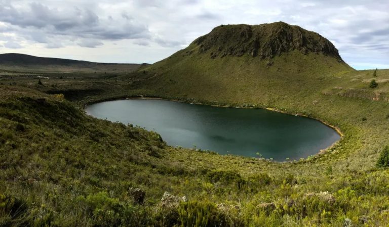
Lake Michaelson (3,950m) — the lake comes into view as the trail descends into the valley. It sits in a natural amphitheatre. The Temple walls rise behind it. The cliffs reflect in the water when conditions are still. On clear mornings, Batian (5,199m) and Nelion (5,188m) are framed in the gap above the far cliff wall.
At 30 acres, Michaelson is not the largest lake on the mountain. It is, however, the most spectacular by a significant margin. The campsite sits on the shore. The view from the tent door is straight across the lake to the volcanic cliff wall. At night, if skies are clear, the stars fill the bowl above you.
This is the day most guests say they did not expect.
🍽️ Meals: Breakfast · Packed lunch overlooking the lake · Dinner at camp · 🏕️ Overnight: Lake Michaelson camp 3,950m
🌊 Day 5 — Michaelson to Hobley Valley Tarns and Mintos Camp (4,300m): The Forgotten Tarn Country
The Hobley Valley is the most tarn-dense zone on Mount Kenya and one of the least-visited sections of the peak circuit.
From Lake Michaelson, the trail climbs steeply through the inner gorge to reach the higher plateau. The altitude gain is significant — from 3,950m to the Hobley Valley at 4,000 to 4,450m. Pace is slower here. The guide sets rhythm.
Carr Lakes (4,000m) — two lakes in the Hobley Valley, named after Ernest Carr, who founded the Mountain Club of East Africa, built a road up the eastern slopes, and erected the first mountain huts. The lakes drain into the Mackinder River which becomes the Rupingazi River below.
Enchanted Lakes (4,250m) — above Carr Lakes, these small lakes earned their name from the reaction of the first explorers who found them. The term "enchanted" was not figurative. The combination of the high-altitude light, the mirror water, and the giant groundsels around the margins creates something visually specific to this mountain at this altitude.
Thompson Tarn (4,350m) and Gallery Tarn (4,450m) — both in the Hobley Valley, both named after early explorers of the mountain. The Gallery Tarn takes its name from its gallery-like appearance when viewed from above.
Halls Tarn (4,300m) — Mintos Camp — the final camp of the day sits at Mintos, the last significant stop before the summit zone. Halls Tarn fills the bowl beside camp — named after F.G. Hall, the District Commissioner who administered the region from Fort Hall (now Murang'a) in the colonial era. The altitude is serious now. Hot dinner. Early rest. Tomorrow is the summit or the high tarns circuit.
🍽️ Meals: Breakfast · Packed lunch at Carr Lakes · Dinner at Mintos · 🏕️ Overnight: Mintos Camp 4,300m
🏔️ Day 6 — High Tarns Circuit or Point Lenana Summit: Your Choice
Two options. Both centre on water. One also touches 4,985m.
Option A — High Tarns Circuit (Non-Summit, Lake-Focused)
This is the pure lake expedition choice. Rather than the pre-dawn summit push, your guide leads a High Tarns Circuit from Mintos at a reasonable 07:00 AM departure.
Lower Simba Tarn (4,390m) — start of Mackinder Valley. Named by porters who reported a lion sighting in this area in 1924.
Upper Simba Tarn (4,600m) — above Simba Col, the glacier influence on the water is tangible at this altitude.
Square Tarn (4,700m) — its name is literal. Below Point Lenana. The shape is visible from the path.
Harris Tarn (4,750m) — the highest lake comfortably visited on this circuit. Named after P. Wyn Harris, who made the first ascent of Nelion with Shipton in 1929. Tarn water at this altitude is glacially clear.
Lewis Tarn (4,800m) — below the Lewis Glacier. This is the highest accessible water body on Mount Kenya. The glacier is retreating — its footprint is significantly smaller than when the tarn was named. The meltwater feeds the tarn. Standing here, surrounded by 4,800m of altitude, the remaining ice field behind you and the tarn in front, is a specific experience.
Hausberg Tarn and Oblong Tarn (4,370m) — the descent loops through the Hausberg Valley, where these paired tarns sit separated by the western peak circuit trail. Both drain to the Nanyuki River.
Return to Shipton's Camp (4,200m) for overnight.
Option B — Point Lenana Summit Push (04:00 AM departure)
Standard pre-dawn summit protocol. The route passes Harris Tarn and the Simba Tarns on the ascent — your guide points them out by headtorch. Point Lenana summit at 4,985m for the sunrise. Descent via Shipton's Camp.
This option adds the summit to the lake expedition. The two experiences are not mutually exclusive.
🍽️ Meals: Early hot drink · Breakfast at Shipton's Camp · Packed lunch · Dinner at Shipton's · 🏕️ Overnight: Shipton's Camp 4,200m
🚐 Day 7 — Sirimon Descent to Nairobi: Hausberg, Hook Tarn, and Out
Hook Tarn (4,100m) — the Sirimon descent passes through the Sirimon Valley along the Timau track section. Hook Tarn at 4,100m is a fly-fishing haven that most Sirimon route trekkers walk past without noticing. Your guide stops here.
Liki North Valley — the descent routes through the open moorland with the glacial valley below.
Old Moses Camp (3,300m) — final rest stop. Tea. Last look up at the peaks.
Sirimon Gate (2,650m) — KWS exit registration. Vehicle transfer to Nanyuki for a meal and then to Nairobi.
Nairobi arrival: evening.
🍽️ Meals: Breakfast · Packed lunch · Vehicle transfer
🎣 Fishing on Mount Kenya — The Angler's Itinerary
Five of the lakes and tarns on this expedition are stocked with rainbow and brown trout — Lake Rutundu, Lake Alice, Lake Ellis, Lake Michaelson, and Hook Tarn. Each lake requires a KWS fishing permit in addition to the standard entry fee.
If your group includes serious fly-fishers, advise us at booking. We allocate additional time at the appropriate lakes and can arrange for light fly-fishing equipment porterage for guests who do not want to carry their own kit to altitude.
The morning session at Lake Rutundu (Day 2) and the early evening at Lake Ellis (Day 3) are the most productive windows. Lake Michaelson's trout are larger on average but the high altitude makes the casting more physically demanding.
💰 2026 Pricing — 7-Day Land of Lakes Expedition
All prices include KWS Mount Kenya National Park entry fees and conservation charges for all 7 days, KWS-certified lead guide, full porter and cooking team, private Nairobi 4×4 transport return, expedition camping tents and sleeping mattresses, cooking equipment, all meals (lunch Day 1 through lunch Day 7 — 13 meals), hot drinks throughout, water purification, first aid support, and AMREF Flying Doctors emergency evacuation cover.
| 👥 Group Size | 🇰🇪 Kenyan Citizens (KES) | 🌐 Non-Residents (USD) |
|---|---|---|
| 1 Person | KES 180,000 | $1,350 |
| 2 Persons | KES 148,000 pp | $1,100 pp |
| 3 Persons | KES 128,000 pp | $950 pp |
| 4 Persons | KES 114,000 pp | $850 pp |
| 5 to 6 Persons | KES 104,000 pp | $780 pp |
Summit option (Day 6 Option B): No additional charge — included in base price if group chooses this option.
KWS fishing permits: KES 500 per lake per day per rod · advise at booking
📌 Sleeping bag rental: KES 500/night — advise at booking
📌 Deposit: 30% confirms dates and guides the team
📌 Cancellation: Full refund 21 days' notice · flexible rescheduling within 12 months
📱 M-Pesa Paybill: 4065921 · Account: Your name plus "MK Lakes"
✅ What Is Included
- ✔ Private return 4×4 transport - Nairobi to Rutundu roadhead and Sirimon Gate to Nairobi
- ✔ All KWS Mount Kenya National Park fees - 7 days
- ✔ KWS-certified lead guide throughout
- ✔ Full porter team - luggage beyond your daypack
- ✔ Skilled cook team - fresh meals at every camp
- ✔ Expedition tents and sleeping mattresses
- ✔ All meals - 13 meals across 7 days
- ✔ Hot drinks - tea, coffee, hot chocolate at every camp
- ✔ All water and water purification
- ✔ First aid kit and emergency response briefing
- ✔ Day 6 Point Lenana summit push - included at no extra charge if group chooses it
❌ What Is Not Included
- ✗ Sleeping bag - rental KES 500/night · advise at booking
- ✗ Personal trekking gear - boots, poles, waterproofs, thermals, headtorch
- ✗ Travel insurance - mandatory, must cover high-altitude trekking and evacuation
- ✗ KWS fishing permits - KES 500/lake/day/rod - advise at booking
- ✗ Tips for guide and porter team - strongly encouraged
- ✗ Alcohol and personal snacks
📅 Best Time for the Lake Expedition
| Month | Conditions | Lake Visibility | Notes |
|---|---|---|---|
| Jan to March | ⭐⭐⭐⭐⭐ | Crystal clear | Peak photography season — best lake reflections |
| April to May | ⭐⭐ | Rain-muddied approaches | Trails soft — not recommended |
| June | ⭐⭐⭐ | Improving | Transition month |
| July to October | ⭐⭐⭐⭐⭐ | Crystal clear | Second dry season — excellent |
| November | ⭐⭐⭐ | Variable | Short rains |
| December | ⭐⭐⭐⭐ | Improving from mid-month | Good from December 15 |
Photography note: The lake reflections of Batian and Nelion at Lake Michaelson are at their best in January-March and July-September, when overnight temperatures drop enough to suppress wind. Still water conditions before 09:00 AM produce the mirror reflections that make this lake famous.
❓ Frequently Asked Questions
How many lakes are there on Mount Kenya?
Mount Kenya has 5 significant named lakes - Lake Alice (48 acres, 3,550m), Lake Rutundu (25 acres, 3,100m), Lake Ellis (28 acres, 3,500m), Lake Michaelson (30 acres, 3,950m), and Lake Höhnel (21 acres, 4,300m) - plus 26 named tarns ranging from Kech Tarn at 3,400m to Lewis Tarn at 4,800m below the Lewis Glacier. In total, Mount Kenya has 31 named water bodies, making it one of Africa's most extraordinary high-altitude lake systems.
Which is the most beautiful lake on Mount Kenya?
Lake Michaelson at 3,950m in the Gorges Valley is widely considered the most spectacular. It sits in a natural amphitheatre shielded by The Temple — a 300-metre vertical cliff. Vivienne Falls feeds the lake from above. The reflections of Batian and Nelion peaks in still morning conditions produce some of the most extraordinary alpine photography in Africa. Halford Mackinder, who made the first ascent of Batian in 1899, regarded the Michaelson viewpoint as the most striking landscape on the entire mountain.
Where did Prince William propose to Kate Middleton on Mount Kenya?
Prince William proposed to Kate Middleton at Lake Rutundu in November 2010. The lake is on the north-eastern slopes of Mount Kenya at 3,100m, accessed via the Kisima turnoff from the Nanyuki-Meru road. The Rutundu Log Cabin sits on the shore. The guest book inside contains a private entry written by Prince William the morning after the proposal.
Do I need to summit Point Lenana to do this expedition?
No. The summit is optional on Day 6. If your group is there for the lakes, we run the High Tarns Circuit as an alternative — visiting Lewis Tarn (4,800m), Harris Tarn (4,750m), Square Tarn (4,700m), Simba Tarns (4,390m and 4,600m), and the Hausberg-Oblong pair (4,370m). This covers the highest accessible tarns without the summit push. For groups that want both experiences, the summit push is included in the package at no additional cost.
Can you fish in the Mount Kenya lakes?
Yes. Lake Rutundu, Lake Alice, Lake Ellis, Lake Michaelson, and Hook Tarn are all stocked with rainbow and brown trout. A KWS fishing permit is required — approximately KES 500 per lake per day per rod. If you are a fly-fisher, advise us at booking and we allocate additional time at the appropriate lakes and can assist with equipment porterage to altitude.
Is this expedition suitable for beginners?
No. Seven days at altitude between 3,100m and 4,800m requires prior multi-day trekking experience and good cardiovascular fitness. This is not a technical climb — no ropes or climbing skills are needed — but the cumulative daily hiking distances, the altitude, and the sustained effort over 7 days make it unsuitable for complete beginners. If you are new to high-altitude trekking, start with our 3-Day Chogoria Sirimon Climb or contact us for a fitness assessment.
How do I book?
WhatsApp +254 729 257 317 with your preferred dates, group size, and whether you want to include the summit option on Day 6 and/or fishing permits. We confirm guide team availability within 24 hours and send a full pre-expedition briefing document. A 30% deposit secures your dates.
📞 Book Your Mount Kenya Lake Expedition
📱 WhatsApp / Call: +254 729 257 317 · +254 734 417 496
🇦🇹 Austria: +43 650 702 1313
📧 [email protected]
📱 M-Pesa Paybill: 4065921 · Account: Your name plus "MK Lakes" 🏔️💧
🌍 Multilingual Summary
🇩🇪 Deutsch: 7-tägige Mount-Kenya-Expedition zu 5 Seen und 10+ Bergteichen — vom Rutundu-See (3.100m) bis zum Lewis-Bergteich (4.800m). KWS-zertifizierter Bergführer, vollständige Trägerunterstützung, alle Mahlzeiten, AMREF-Notfallversicherung und Forellenfischen auf Anfrage. Ab $780 pro Person. WhatsApp: +254 729 257 317 · Österreich: +43 650 702 1313
🇫🇷 Français: Expédition de 7 jours sur le Mont Kenya à travers 5 lacs et plus de 10 tarns alpins — du lac Rutundu (3 100m) au lac Lewis (4 800m). Guide certifié KWS, porteurs complets, tous les repas, couverture d'urgence AMREF et pêche à la truite sur demande. À partir de $780 par personne. WhatsApp : +254 729 257 317
🇪🇸 Español: Expedición de 7 días por el Monte Kenia a través de 5 lagos y más de 10 tarns alpinos — desde el lago Rutundu (3.100m) hasta el lago Lewis (4.800m). Guía certificado KWS, equipo de porteadores completo, todas las comidas, cobertura de emergencia AMREF y pesca de truchas disponible. Desde $780 por persona. WhatsApp: +254 729 257 317
Where You Will Visit
This safari explores the following regions in Kenya
- Chogoria, Tharaka-Nithi County