Mount Satima Wandare Route Summit Challenge
Safari at a Glance
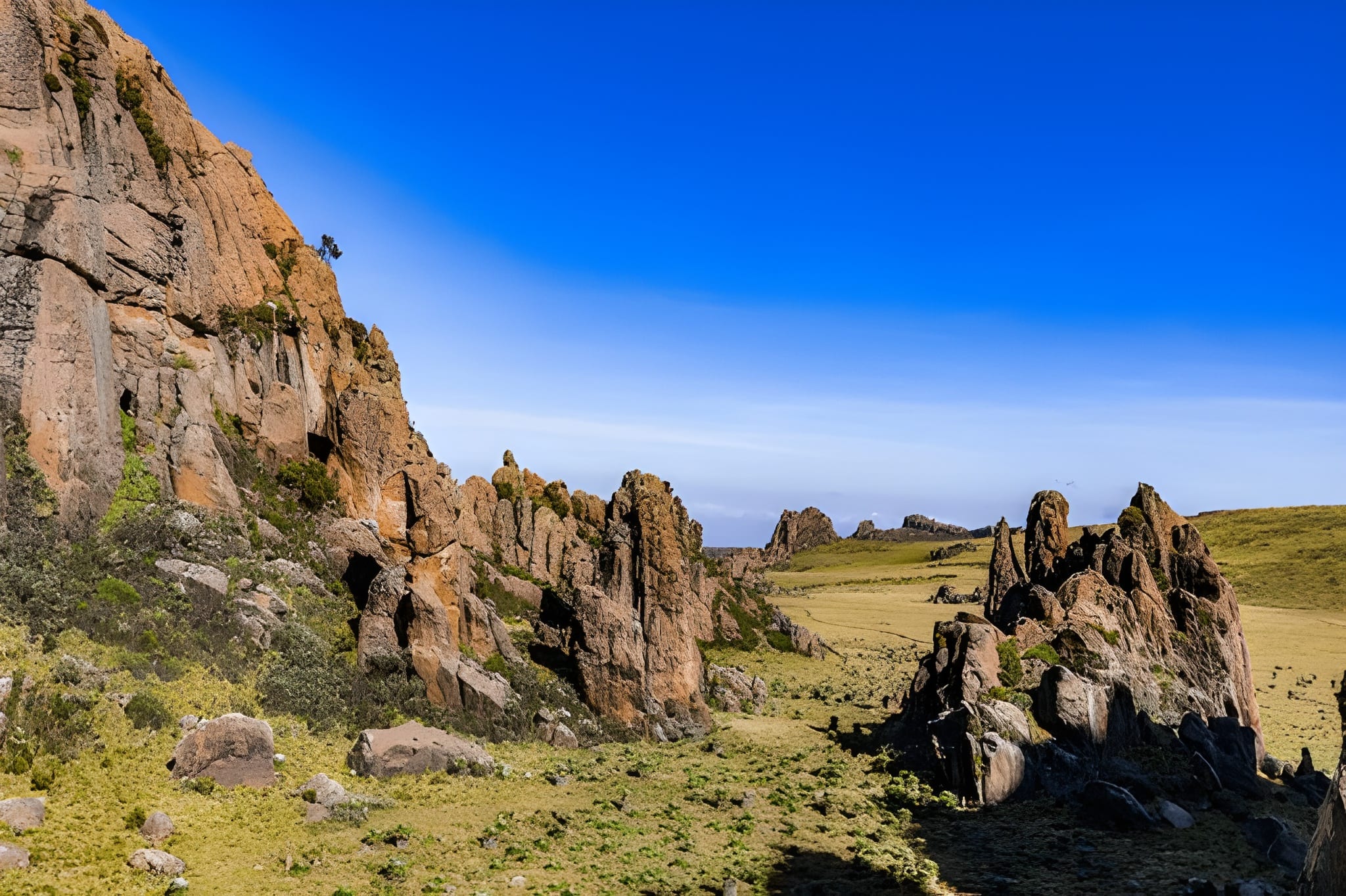
Wild Springs Adventures | 📍 Wandare Gate · Mweiga, Nyeri County · Mweiga Gate · 4,001 Metres · The Direct Ascent
🐂 The Mountain That Doesn't Give You an Easy Way In
Both routes to Mount Satima end at the same summit. The same 4,001 metres. The same panorama of Mount Kenya to the east and the Great Rift Valley to the west. The same thin air and the same sense that you have stood somewhere genuinely significant.
What separates the Wandare route from the Dragon's Teeth is everything that happens before the summit.
The Dragon's Teeth route arrives at the trailhead already at 3,400m, already in the open moorland, already with views. The Wandare route does not offer that. You drive 15 to 20 kilometres through dense bamboo forest — elephant country, buffalo country, the wildlife-heavy eastern salient of Aberdare National Park — and your trailhead sits at approximately 3,200 to 3,300 metres on the moorland edge. From there, the trail climbs steeply and directly. No dramatic rock formations as a mid-trail reward. No gentle meander through photogenic volcanic spires. Just 10.5 kilometres of raw Afro-alpine moorland, steep gradient, rolling U-shaped valleys, and 800 metres of hard-earned altitude gain between you and the highest point in the Aberdares.
This is precisely why experienced hikers and climbers preparing for Mount Kenya or Kilimanjaro choose it.
The Wandare route is shorter in distance but harder in effort — a distinction that every competitor page either misses entirely or explains poorly. It is the right trail for a specific kind of hiker: one who has already completed a serious high-altitude day hike, who can accurately assess their fitness, and who wants altitude gain and endurance training over scenery and accessibility. If that hiker is you, the Wandare route is the most efficient, most honest, and most rewarding way to stand on top of the Aberdares.
🎯 The honest truth:
The Wandare route is often described as "shorter" as if that makes it easier. It is not easier. The elevation gain per kilometre is greater than on the Dragon's Teeth side. The terrain lacks the visual breaks that make long ascents feel faster. The bamboo forest drive in — with active elephant and buffalo — means your ranger is working from the moment you leave the vehicle. This is the route for serious hikers. If you are coming to Satima for the first time, are not sure of your fitness at altitude, or want the most dramatic visual experience, the Dragon's Teeth route from Shamata is the correct choice. This page is for everyone else.
📋 Mount Satima Wandare Trek at a Glance
| 🐂 Summit | Ol Donyo Lesatima (Mount Satima), 4,001m (13,127ft) |
| 🇰🇪 Ranking | 3rd highest mountain in Kenya · Highest in the Aberdares |
| 📈 Elevation Gain | ~800m from moorland trailhead |
| 📏 Distance | ~21km round trip (~10.5km each way) |
| ⏱️ Time on Trail | 6–8 hours |
| 📍 Trailhead | Moorland roadhead, ~3,200–3,300m |
| 🚪 Entry Gate | Wandare Gate, Mweiga, Nyeri County |
| 💪 Difficulty | Hard — advanced hikers, not beginner-friendly |
| 🛣️ Distance from Nairobi | ~212km (approx. 3.5–4.5 hrs drive) |
| 🚙 Park Drive In | 15–20km through bamboo forest — wildlife viewing from vehicle |
| 🪖 Guide Requirement | Armed KWS ranger + certified guide — mandatory |
| 👁️ Summit Views | Mount Kenya · Rift Valley Lakes · Laikipia · Mau Escarpment |
| 🎯 Best For | Advanced hikers · Mount Kenya preparation · acclimatisation training |
🌾 What Makes This Wandare Route Different
There are two ways to misunderstand the Wandare route. The first is to assume that "shorter" means easier. The second is to assume it is the inferior option because it lacks the Dragon's Teeth. Both are wrong in different ways.
On the gradient: The Dragon's Teeth route gains ~600m over 8km from Twin Rocks trailhead. The Wandare route gains ~800m over 10.5km from the moorland roadhead. On paper, the numbers look similar. On your legs, they feel different — because the Wandare ascent is more direct, with fewer level sections to recover on, and the altitude gain hits harder from a slightly lower starting point. By the time you reach the upper moorland above 3,700m, the air is genuinely thin, and the pace has dropped whether you plan for it or not.
On the terrain: The Wandare moorland is not like the Dragon's Teeth plateau. On the Shamata side, the trail winds across a broad, open plateau with dramatic rock formations at regular intervals. On the Wandare side, the trail climbs through rolling Afro-alpine moorland — golden tussock grassland, U-shaped glacial valleys, steep heather ridges, and the occasional dramatic rock outcrop — but the landscape's beauty is quieter, more sustained, and less theatrical. The reward is not a single photogenic feature. It is the cumulative experience of a long, hard climb through undisturbed high-altitude wilderness.
On the wildlife: The bamboo forest drive from Wandare Gate to the moorland roadhead is one of the best wildlife drives inside Aberdare National Park. The eastern salient has dense elephant and buffalo populations. Colobus monkey troops are commonly spotted in the forest canopy. The drive alone — before a single hiking step — can produce more wildlife sightings than the entirety of the Dragon's Teeth hike. Your ranger is armed for a reason from the moment you leave the gate.
On the solitude: The Wandare route sees significantly fewer hikers than the Dragon's Teeth trail. The moorland above the roadhead is quieter, less disturbed, and more genuinely wild. If you are hiking to experience a mountain rather than to photograph a famous formation, this is the route that delivers that experience most completely.
🕐 The Full Day Mount Satima Wandare Trek Itinerary — Hour by Hour
🚐 05:00 · Nairobi · Departure
An hour earlier than the Dragon's Teeth departure. The Wandare Gate is approximately 212km from Nairobi — roughly 3.5 to 4.5 hours depending on road conditions. The route goes north through Thika, Karatina, and Nyeri, then branches off the Nyeri-Nyahururu highway at Mweiga. The Wandare Gate is signposted from the main road. You arrive as the highland mist is lifting off the bamboo canopy.
🏕️ 08:30 · Wandare Gate, Mweiga · Registration & Briefing
Park entry fees are paid at the KWS headquarters in Mweiga before proceeding to the gate. Your armed KWS ranger is collected here. The guide briefs the group — specifically on the wildlife protocol for the bamboo forest drive, the mandatory descent time (15:00), and what to expect from a trail that the ranger describes plainly: steep, sustained, and worth it.
🌳 08:30 – 09:15 · Wandare Gate → Moorland Roadhead (Drive Through)
The 15–20km drive through the park's bamboo forest is done in a vehicle for safety. The bamboo canopy is dense, and the road is narrow — and the wildlife is active. Black-and-white Colobus monkeys swing through the forest edge. Elephant tracks cross the road regularly; live encounters are common. Buffalo herds move through the bamboo margins. Spend this drive watching, not sleeping. Your guide will slow the vehicle whenever something worth stopping for appears. By the time the bamboo gives way to moorland and the roadhead car park comes into view, you are already at approximately 3,200–3,300m, and the world looks very different from Nairobi.
📋 09:15 – 09:30 · Moorland Roadhead, ~3,200m · Briefing & Start
Out of the vehicle. The trail begins here. The moorland opens ahead: golden tussock grass rolling toward the ridge, the summit invisible from this angle, the sky enormous. Your guide briefs the pace: slow and consistent from the first metre. You are already at altitude. The first 30 minutes are the most important for setting the right rhythm.
🌾 09:30 – 11:30 · 3,200m – 3,600m · The Lower Moorland Ascent
The trail climbs steadily through open Afro-alpine moorland. Tussock grass, Giant Heather (Erica arborea), scattered rock outcrops, and drainage channels where Giant Lobelia (Lobelia deckenii) stands at the wetter sections. The views open quickly — rolling hills and glacially carved U-shaped valleys stretching south and west, with the Aberdare ridgeline visible above. The gradient is consistent and demanding. There are no false summits to mislead you, but there are also no dramatic formations to punctuate the effort. This section rewards mental focus more than physical strength. Keep drinking, keep moving, keep the pace below what feels necessary.
🦬 Wildlife note: Buffalo groups are occasionally encountered on the lower moorland above the roadhead. Your ranger walks between you and any encounter. Do not separate from the group.
⛰️ 11:30 – 13:30 · 3,600m – 3,900m · The Upper Moorland — Where the Altitude Arrives Above 3,600m
The trail steepens into the upper moorland ridge. The tussock gives way to shorter alpine vegetation — Helichrysum spp. (everlasting flowers) on exposed rocky sections, Lady's Mantle (Alchemilla hageniae) in the wetter drainage channels, Giant Senecio (Dendrosenecio battiscombei) standing on the most exposed ridges. The air is perceptibly thinner. Sentences get shorter. Pace drops 20% without any decision being made. This is normal. This is the altitude. Walk through it at the pace your body sets, not the pace your ambition suggests.
The moorland here — undisturbed, wide open, and almost entirely lacking in other hikers — has a quality that is hard to describe and easy to remember. The U-shaped valleys below you were carved by glaciers during the last ice age. The rocky outcrops above you are the same ancient volcanic material as the Dragon's Teeth, just less theatrical in presentation. The summit ridge becomes visible from this section. It is closer than it looks. Or further. Altitude plays tricks.
🏅 13:30 – 14:00 · 3,900m – 4,001m · Final Ridge R
ocky, steep, demanding on the knees of anyone who rushed the lower sections. Your ranger goes first. The summit plateau opens. The sign: Ol Donyo Lesatima — 4,001 metres.
🏆 14:00 · 4,001m · THE SUMMIT
Kenya's third-highest mountain. The Aberdare's highest point. The same view that the Dragon's Teeth hikers earn from the other side, now from directly above where you ascended. Mount Kenya fills the eastern horizon — enormous, white-capped, indifferent to the effort it took to earn this view of it. The Rift Valley Lakes — Naivasha, Nakuru, Elementaita — lie to the west below a landscape that drops away dramatically from the escarpment. Laikipia's cattle plains roll north. Lake Ol Bolosat glints below. On clear dry-season mornings, the Mau Escarpment appears at 150km.
Eat your summit lunch here. The views north differ slightly from the Dragon's Teeth approach — you are looking back toward the eastern Aberdare slopes and the Mweiga valley below. Sit for twenty minutes. Breathe slowly. This is what the effort was for.
15:00 — descent begins. Non-negotiable.
⬇️ 15:00 – 17:30 · 4,001m → 3,200m · Descent
The descent retraces the ascent. The upper moorland section is steep and demands attention on tired legs. Trekking poles are critical here. The lower sections move faster, but the cumulative fatigue from the ascent means the technical sections near the roadhead require the same caution as on the way up.
Back at the roadhead by 17:30. Drive back through the bamboo — different light, different wildlife possibilities. Wandare Gate exit by 18:00. Nairobi by 21:30–22:00.
🗺️ The Three Trail Sections Mount Satima Wandare Trail
🌿 Section 1 · Moorland Roadhead → 3,600m · Lower Moorland Ascent
Open tussock moorland, consistent steep gradient, U-shaped valleys below, no dramatic formations — just sustained, beautiful, demanding hill walking. The section that filters those who paced correctly from those who did not.
⛰️ Section 2 · 3,600m – 3,900m · Upper Moorland Ridge
The altitude arrives fully. Giant Senecio on exposed ridges. Shorter vegetation. Wider views. The summit ridge visible ahead. The section where the body has an opinion about pace that is different from the mind's.
🏅 Section 3 · 3,900m – 4,001m · Final Ridge & Summit
Rocky, steep, the last test before the plateau opens. The section that earns the view.
🌿 Flora
The Wandare route runs entirely in the Afro-alpine zone above 3,200m — pure high-altitude moorland species, with the additional character of Hagenia abyssinica (African Redwood) forest visible during the bamboo drive. The Hagenia section, with its gnarled orange-red bark and fern-draped branches, is one of the most atmospheric tree communities in the Aberdares and visible at close range from the vehicle.
On the trail itself, the same core species as the Dragon's Teeth side — tussock grass, Giant Lobelia, Giant Heather, Helichrysum everlasting flowers, Lady's Mantle in drainage channels — but the Wandare upper moorland is less frequently walked, which means the Dendrosenecio battiscombei and lobelia communities on the upper ridges are notably less disturbed. The Aberdare Range holds 778 recorded plant species, including 63 endemics — the Wandare eastern moorland contributes a disproportionate share of the least-documented among them.
🦁 Wildlife & Nature
The Wandare route's defining wildlife advantage is the bamboo forest drive. The 15–20km road through the eastern salient is genuine wildlife country — not a safari park, but an active ecological corridor used by some of the Aberdares' most significant large mammal populations.
| 🐾 Species | 👁️ Likelihood | 📍 Where |
|---|---|---|
| 🐘 Forest Elephant | ★★★★☆ | Bamboo forest drive — tracks, droppings, and live encounters |
| 🦬 Buffalo | ★★★★☆ | Bamboo forest drive and lower moorland |
| 🐒 Black-and-White Colobus | ★★★★★ | Bamboo forest canopy on the drive in — highly reliable |
| 🦌 Mountain Reedbuck | ★★★★☆ | Upper moorland sections |
| 🦌 Eland | ★★★☆☆ | Lower and mid-moorland open sections |
| 🐆 Leopard | ★★☆☆☆ | Bamboo forest edges — sign more common than sighting |
| 🦁 Serval Cat | ★★☆☆☆ | Upper moorland above 3,600m |
| 🐦 290+ Bird Species | ★★★★★ | Bamboo forest & all moorland zones |
🔭 Birding at Mount Satima Wandare Trail
The Wandare route offers birding across two completely distinct habitats in one day — the species-rich bamboo forest (drive-in) and the Afro-alpine moorland (trail). This dual-habitat combination is unique among Satima access routes and genuinely rewarding for birders.
- Aberdare Cisticola (Cisticola aberdare) — Kenya's true highland endemic. The tussock moorland on the Wandare side is prime habitat, less disturbed than the Shamata side.
- Jackson's Francolin (Pternistis jacksoni) — near-endemic to Kenya's central highlands; regularly heard in the heather transition zones.
- Hartlaub's Turaco — brilliant crimson wings in the bamboo forest. Heard before seen; its hollow call carries through the canopy on the drive-in.
- African Crowned Eagle — nests in the Aberdare forests; occasionally seen soaring above the bamboo canopy.
- Scarlet-tufted Malachite Sunbird — follows the Giant Lobelia flowering cycle through the upper moorland.
- Moorland Chat — conspicuous on exposed rocks from 3,400m through the summit plateau.
- Mountain Buzzard — soars on morning thermals above the moorland ridge.
Log your sightings at the Aberdare National Park eBird hotspot. The Wandare eastern moorland is significantly under-recorded compared to the Shamata side.
💰 Mount Satima Wandare Hike 2026 Pricing — Per Person by Group Size
Everything included. No gate surprises.
| 👥 Group Size | 🇰🇪 Kenyan Citizens | 🌍 EA Residents | 🌐 International |
|---|---|---|---|
| 1 person (private) | KES 28,500 | KES 31,500 | USD 350 |
| 2 persons | KES 15,500 | KES 17,500 | USD 190 |
| 3 persons | KES 11,500 | KES 12,500 | USD 150 |
| 4 persons | KES 7,500 | KES 9,000 | USD 135 |
| 5 persons | KES 7,500 | KES 9,000 | USD 135 |
| 6 persons | KES 7,500 | KES 9,000 | USD 135 |
| 7 persons | KES 7,500 | KES 9,000 | USD 135 |
| 🚗 Self-drive (meet at gate) | KES 4,200 | KES 4,800 | USD 90 |
Groups of 8 and above — contact us for a custom quote. Traverse option (ascend Wandare, descend Dragon's Teeth or vice versa) carries a small vehicle logistics surcharge.
✅ What's Included
- 🚐 Return transport from Nairobi (4×4 vehicle, CBD/Westlands pickup)
- 🏞️ Aberdare National Park entry fees (KWS eCitizen)
- 🚗 Vehicle park entry and drive-in fees
- 🪖 Mandatory armed KWS ranger for the full day
- 🧭 Certified Wild Springs mountain guide
- 🍱 Summit picnic lunch + trail snacks
- 💧 Drinking water (3 litres per person)
- 📸 Professional photography (digital gallery within 48 hours)
- 🩺 Emergency first aid kit and evacuation support
- 📋 All government taxes
❌ Not Included
- 👟 Personal hiking gear (rentals available — see below)
- 🛡️ Travel insurance (strongly recommended — purchase before trip)
- 🙏 Guide & ranger tips (KES 1,000–1,500 per person suggested)
- 🍳 Breakfast (eat before pickup or bring food for the vehicle)
🎒 Gear Rentals
| Item | Daily Rate |
|---|---|
| 🥢 Trekking poles | KES 500 |
| 🦵 Gaiters | KES 300 |
| 🎒 Day pack (30L) | KES 400 |
⚠️ Safety on This Trail
⚠️ This Is Not a Beginner Trail
The Wandare route requires previous high-altitude hiking experience. The steep, sustained gradient combined with genuine altitude gain from a lower starting point can push first-timers beyond their capacity. Wild Springs guides assess the group at the trailhead and will make honest recommendations if the pace during the first 30 minutes suggests the summit attempt should be modified. This is not gatekeeping — it is the reason our groups return safely.
⚠️ The Bamboo Forest Section Has Active Large Wildlife
The drive to the moorland roadhead passes through territory with daily elephant and buffalo activity. Stay in the vehicle during this section unless your guide and ranger have assessed the immediate area as clear. The ranger is armed for this reason from the moment you leave the gate.
⚠️ Steeper Descent than Dragon's Teeth
The Wandare descent is steeper per kilometre than the Shamata route and hits tired legs on terrain that does not offer the wide, flat moorland sections of the Dragon's Teeth side. Trekking poles are not optional on the descent. Take the same care going down as going up.
⚠️ Bogs Throughout
The Wandare moorland has wet bog sections in all seasons. Gaiters and waterproof boots prevent the worst — nothing prevents all of it. Walk on the tussock grass clumps, not between them.
⚠️ Altitude Effects Are More Pronounced Than on Dragon's Teeth
The Wandare route starts lower (~3,200m vs ~3,400m at Twin Rocks) and climbs harder. The cumulative altitude stress by the time you reach 3,800m is greater than on the Shamata side. Standard altitude protocol: slow pace, 3 litres of water, immediate descent if symptoms worsen.
🎒 What to Bring Mount Satima Wandare Hike
🥾 Footwear & Lower Body
- Waterproof hiking boots with ankle support — broken in well. The upper moorland sections are rocky and require ankle stability.
- Gaiters — mandatory. The drainage channels through the Wandare moorland are wet in all seasons.
- Long hiking trousers — the heather and grass on the steeper sections catch bare legs
- Two hiking sock pairs — one dry spare in a waterproof bag
🧥 Clothing Layers
- Moisture-wicking base layer — no cotton, ever
- Substantial insulating mid-layer — the Wandare route is colder at the summit than the Dragon's Teeth side due to the eastern exposure
- Waterproof, windproof shell — non-negotiable
- Warm hat and gloves — the summit at 4,001m with an easterly wind requires both
- Sun hat — UV intensity on open moorland at altitude is significant
🎒 Gear & Food
- Trekking poles — critical on the descent; the steep Wandare trail is where knees are earned or lost
- 3 litres of water minimum — no reliable trail sources above the roadhead
- High-calorie packed lunch (provided) + substantial personal snacks — this is a longer, harder day than Dragon's Teeth
- Camera — the U-shaped valleys below the trail and the bamboo forest drive reward a charged battery
- Binoculars — bamboo forest, drive birding, and upper moorland raptor watching
- Headlamp with fresh batteries
- Sunscreen SPF 50+
- Personal first aid: blister pads, paracetamol, ibuprofen for knees, personal medication
- Change of clothes for the vehicle — you will be cold and damp at the end
🏪 All gear available at the Wild Springs Outdoor Store. For this specific route, ask our team about gaiters for bog terrain and trekking pole selection for steep gradient descent.
🏅 The Best Mount Kenya Preparation Hike in the Aberdares
The Wandare route is the answer to a specific question that serious hikers preparing for Mount Kenya ask: where can I test my body at 4,000m without committing to a multi-day expedition?
The Dragon's Teeth route answers part of that question. The Wandare route answers it more completely — because the sustained steep gradient, the lower starting point, and the greater elevation gain per kilometre more closely replicate the physical demands of a hard expedition day at altitude. The difference matters when the real test is Lenana at 4,985m via Naro Moru or Sirimon.
Three things the Wandare route tells you before you book Mount Kenya:
1. Whether your lungs handle a sustained steep gradient at altitude. The Dragon's Teeth is gentle enough that moderate cardiovascular fitness carries most people to the summit. The Wandare route is not. If you can maintain a steady pace on the upper Wandare moorland without stopping every 100 metres, your lungs are ready for Mount Kenya.
2. Whether your legs handle a serious descent after altitude. The Wandare descent tests tired legs on steep terrain in a way that the Dragon's Teeth does not. The technical nature of the lower Wandare trail on the way down is the closest day-hike equivalent to the final descent sections on Mount Kenya routes.
3. Whether your pacing strategy is correct. The Wandare route punishes going out too fast in the lower sections with nothing left for the upper moorland. This is exactly the pacing lesson that matters most on a big mountain day.
If the Wandare route feels challenging but manageable, Point Lenana is within realistic reach. If it breaks you, you know exactly what to train.
📅 When to Go Mount Satima Wandare Hike
| 📆 Month | ⭐ Conditions |
|---|---|
| January | ⭐⭐⭐⭐⭐ Ideal — firm trail, clear summit views, cold mornings |
| February | ⭐⭐⭐⭐⭐ Ideal — best clarity of the year |
| March | ⭐⭐⭐ Okay — early rains, bogs deepen |
| April | ⭐ Avoid — heavy bog on steep trail becomes hazardous |
| May | ⭐ Avoid — worst conditions |
| June | ⭐⭐⭐⭐ Good — dry season opens |
| July | ⭐⭐⭐⭐⭐ Ideal |
| August | ⭐⭐⭐⭐⭐ Ideal |
| September | ⭐⭐⭐⭐ Good |
| October | ⭐⭐⭐ Variable — short rains unpredictable |
| November | ⭐⭐ Risky — steep trail becomes slippery |
| December | ⭐⭐⭐⭐ Good — rains ease off |
📊 Wandare vs Dragon's Teeth — The Honest Comparison
| 🌾 Wandare (This Route) | 🐉 Dragon's Teeth | |
|---|---|---|
| Distance | ~21km round trip | ~16km round trip |
| Elevation Gain | ~800m | ~600m |
| Duration | 6–8 hours | 5–7 hours |
| Trailhead Altitude | ~3,200–3,300m | ~3,400m |
| Difficulty | Hard | Moderate |
| Signature Feature | Raw moorland, U-shaped valleys, bamboo drive wildlife | Dragon's Teeth formations, Nipple Rock, Drive-in wildlife |
| Scenery Style | Sustained wilderness, quieter | Dramatic & photogenic |
| Best For | Advanced hikers, Mount Kenya prep, acclimatisation | First-timers, photographers, families |
| Drive from Nairobi | ~212km (3.5–4.5 hrs) | ~160km (3–3.5 hrs) |
Neither route is better. They are different. The right answer depends entirely on who you are and what you want from the mountain.
📊 Mount Satima Wandare Hike vs Other Aberdare Trails
| 🏔️ Trail | ⬆️ Summit | 💪 Difficulty | 🎯 Best For | ⏱️ Time |
|---|---|---|---|---|
| 🌿 Mount Kipipiri | 3,349m | Moderate | Wildflowers, history | 8–9 hrs |
| 🐘 Elephant Hill | 3,658m | Hard | First serious challenge | 7–10 hrs |
| 🪨 12 Apostles | 3,672m | Very Hard | Kenya's toughest day hike | 12–17 hrs |
| 💧 Seven Ponds | 3,826m | Hard | Glacial tarns, solitude | 7–10 hrs |
| 🌾 Rurimeria Hill | 3,860m | Strenuous | Mount Kenya training | 7–10 hrs |
| ⛰️ Kinangop | 3,906m | Hard–Very Hard | Technical summit | 9–12 hrs |
| 🐉 Satima Dragon's Teeth | 4,001m | Moderate | Most scenic, first 4,000m | 5–7 hrs |
| 🌾 Satima Wandare | 4,001m | Hard | Advanced hikers, Mount Kenya prep, raw wilderness | 6–8 hrs |
Source: AllTrails — Aberdare National Park · Wild Springs guided records.
🔄 Traverse Option — Get the Best of Both
For hikers who want to experience the complete Satima character in one day, the traverse combines Wandare and Dragon's Teeth in either direction.
Ascend Wandare → Descend Dragon's Teeth: The harder route as the approach, the most scenic route as the reward on the way down. The Dragon's Teeth formations in the afternoon light from the descent direction are extraordinary.
Ascend Dragon's Teeth → Descend Wandare: The dramatic formations are the visual motivation on the way up, the raw wilderness character of the Wandare moorland as the descent experience. Finish at a different gate from where you started.
Both traverse options require two vehicles or a vehicle shuttle. Contact Wild Springs to arrange logistics — all traverse options are private bookings only.
👥 Private & Custom Options Mount Satima Wandare Hike
👥 Private Groups (1–7 Persons)
All departures on this route are private. The Wandare trail demands the guide's complete attention on terrain that rewards a personal pace rather than a group schedule. Pricing per the table above.
🎯 Mount Kenya Preparation Programme
Wild Springs can design a structured acclimatisation programme using the Wandare route as the key altitude training step before a Mount Kenya expedition. Contact us with your summit date and we will build the preparation timeline from there.
🏕️ Overnight Option
Some groups prefer to camp at a site near the Wandare Gate the night before, start the hike from a rested 04:00 dawn departure, and have the full day's light available for the upper moorland sections. We can organise accommodation in the Mweiga area on request.
🗺️ Also on Mount Satima
This page covers the Wandare route. For the complete Satima picture and the Dragon's Teeth experience:
- 🏅 Mount Satima — Complete Guide (Both Routes) — route comparison, traverse options, full context
- 🐉 Mount Satima — Dragon's Teeth Route (Shamata) — most scenic, most accessible, most dramatic
🤝 Why Wild Springs Adventures is the best to lead Mount Satima Wandare Hike
- ⭐ TripAdvisor Award Winner — verified reviews from real hikers and climbers
- 🏛️ Kenya Tourism Authority Licensed — fully registered tour operator
- 🌍 TOSK Kenya Member — Tour Operators Society of Kenya
- 🧗 MCK Certified Guides — Mountain Club of Kenya; our Wandare route guides know the terrain's demands and the bamboo wildlife protocols
- 📸 Professional Photography Included — digital gallery within 48 hours
- 🤝 Fair Pay — guides and rangers paid above industry standard
- 🌿 Leave No Trace — zero plastic policy, all waste carried out
💳 How to Book & Pay
📱 M-Pesa Paybill
- Paybill: 4065921
- Account: Your name + "Satima Wandare"
After payment, WhatsApp your name, date, group size, and your two most recent high-altitude hikes. This route requires a brief experience confirmation.
🏢 Credit Card Cash at the Office
Valley View Office Park, Tower A, First Floor, Sixth Avenue Parklands, off Limuru Road, Nairobi
Mount Satima Contacts
📞 +254 729 257 317 · +254 734 417 496 · +254 721 957 652
📧 [email protected] · wildspringssafaris@gmail.com
Where You Will Visit
This safari explores the following regions in Kenya
- Aberdares