⛰️ Mount Kinangop — The Second Summit Southern Aberdare Range
Safari at a Glance
Wild Springs Adventures | 📍 Mutarakwa Forest Station, Nyandarua County
🏔️ Mother Kinangop Respects Nobody
There is a nickname that circulates through the Kenyan hiking community for the second-highest peak in the Aberdare Range. They call it Mother Kinangop. The name is ironic. There is nothing gentle about this mountain. It is long, steep in the right places, boggy across the moorland, cold at the summit, and finished with a rocky scramble that sorts out those with nerve from those without. Every experienced hiker who has done all the Aberdare trails puts Kinangop near the top — not because it is the highest, but because it demands the most of the person attempting it.
Mount Kinangop, also written as Ilkinangop, rises to 3,906 metres (12,815ft) above sea level at the southernmost end of the main Aberdare ridge. It is a dormant volcano. Its name traces to the Kikuyu phrase Ki-Nyangop — thought to mean "place of ostriches" — referencing the open plateau at its western base where these birds once grazed. Today that plateau is known as the Kinangop Plateau: one of Kenya's most important highland grasslands and the stronghold of the Endangered Sharpe's Longclaw, one of Kenya's rarest endemic birds.
Two summits sit approximately 500 metres apart at the mountain's peak, connected by a jagged rock ridge. The higher of the two reaches 3,906m. The second stands at 3,864m. Between them is the section of trail that filters the committed from the cautious — a rocky face on the right-hand side of the first summit that requires genuine scrambling. Not technical climbing. But real, hands-on, exposed rock work that demands a clear head and respect for height. If you have a fear of heights, you will know it on Kinangop. If you do not, you will stand at 3,906m and look out over a view that few Kenyans have ever seen: the full southern Aberdare range below you, Elephant Hill to the south, the 12 Apostles massif to the east, Lake Naivasha and Mount Longonot to the west, and on a perfect day, the peaks of Mount Kenya floating above the clouds to the northeast.
The Nyandarua Mountains — the proper name for the Aberdare Range — sit on Kenya's UNESCO World Heritage Tentative List, recognised as one of East Africa's most complete and ecologically important montane ecosystems. Kinangop is the range's southern anchor. It is the mountain that faces everything south of the Aberdares. It is the one that watches over Nairobi, 160km away.
🎯 The honest truth:
This is not a mountain for average fitness or casual hikers. Even experienced hikers are regularly humbled by the 1,300m elevation gain, the boggy moorland, and the rocky summit scramble. The day is long — 9 to 12 hours depending on your pace and which route you take. The weather above 3,500m can deteriorate in minutes. The trail via Mutarakwa is the most accessible route, and it is still one of the hardest day hikes in Kenya. Come prepared, or come back when you are. But if you are ready — genuinely ready — this summit is one of the most complete mountain experiences within driving distance of any major African city.
📋 Mount Kinangop Trek at a Glance
| ⛰️ Summit | Mount Kinangop (Ilkinangop), 3,906m (12,815ft) |
| 🥈 Second Summit | 3,864m — climbable on the same day, 500m from the main peak |
| 📈 Elevation Gain | ~1,300m from Mutarakwa Forest Station |
| 📏 Distance | ~24–28km round trip (Mutarakwa route) |
| ⏱️ Time on Trail | 9–12 hours |
| 📍 Trailhead | Mutarakwa Forest Station, Nyandarua County |
| 🗓️ Trailhead Altitude | 2,600m (8,530ft) |
| 💪 Difficulty | Hard to Very Hard — experienced hikers only |
| 🧗 Summit Type | Rocky scramble — hands required, fear of heights a real issue |
| 🛣️ Distance from Nairobi | ~110–160km (approx. 3 hrs drive) |
| 🪖 Guide Requirement | Armed KWS ranger + certified guide — mandatory |
| 🌍 UNESCO Status | Nyandarua Mountains on Kenya's World Heritage Tentative List |
🗺️ Mount Kinangop Two Routes — Know Before You Choose
🌿 Route 1 — Mutarakwa Forest Station (Recommended Day Hike)
The recommended approach for the day hike. Starting at Mutarakwa Forest Station (2,600m) on the northwest side of the mountain, the trail is longer in distance but gains altitude more gradually through plantation forest, bamboo, and moorland before the final push south along the ridge to the summit. Distance: ~24km round trip. Time: 9–11 hours. The solitude on this route is exceptional — very few other groups use it.
🐘 Route 2 — Njabini via Elephant Hill (Extreme)
The infamous traverse. Starting at Njabini Forest Station (2,500m), this route climbs Elephant Hill first (3,658m), descends into the Kinangop Valley moorland (~3,400m), then pushes north along the ridge to Kinangop's summit. Distance: ~28–32km. Elevation gain: 1,700m+. This is the Mother of all Aberdare hikes. Groups completing this route in one day are rare. Most spend a night on the moorland. If you are considering this route, contact us for a proper assessment.
This package covers the Mutarakwa Day Hike — the standard route.
🕐 The Full Day — Hour by Hour
🚐 04:00 – 04:30 · Nairobi · Departure An early start is non-negotiable on Kinangop. The drive via Nakuru Road and Engineer takes approximately three hours. The last 7km from Engineer to Mutarakwa Forest Station are on an unpaved, uneven murram road — slow and rough but passable in a standard vehicle. You arrive as the light breaks over the eastern escarpment, the air cold and the mountain invisible above the treeline.
📋 07:00 – 07:30 · Mutarakwa Forest Station, 2,600m · Briefing & Start KWS park entry paid. Armed ranger collected. Your guide briefs the group. The initial 2km of the trail cross relatively flat forest and farmland on a wide dirt road. A gate on the right marks your entry into the protected forest. Through the gate and the character of the trail changes immediately. The real hike begins.
🌲 07:30 – 09:00 · 2,600m – 3,000m · Plantation to Protected Forest The first 4km from Mutarakwa follow a dirt road through plantation forest — scent-filled cypress and pine, cool shade, the smell of damp soil. Then the track enters the protected area. The gradient steepens. The trees change. You are in the Aberdare's protected montane forest now. Elephant and buffalo footprints appear on the muddy trail. The forest is thick and enclosed. Your guide sets a steady pace — there is a long day ahead.
🎋 09:00 – 11:00 · 3,000m – 3,300m · The Bamboo Zone Dense Yushania alpina bamboo closes in from both sides. Single-file trail. Muddy, steep, and relentless. The canopy blocks most light. The altitude is climbing, and the air is perceptibly thinner. This section of the trail can be the most physically draining — the bamboo gives you nothing to look at except the trail ahead and the trail behind. Push through it. What comes next is the reward.
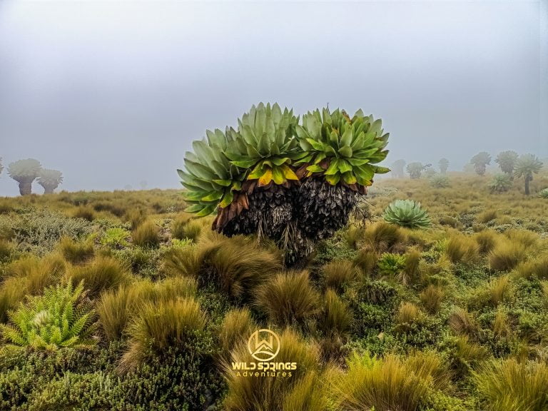
🌳 11:00 – 12:00 · 3,300m – 3,500m · Hagenia Forest — The Transition As the bamboo thins, the Hagenia abyssinica (African Redwood) trees begin to dominate — gnarled, moss-draped, ancient trees with orange-red bark and heavy fern-draped branches. This transition zone is one of the most atmospheric sections of trail in the Aberdares. The Hagenia trees soon give way to Giant Heather (Erica arborea) as the forest opens onto the moorland. The sky appears above. The bamboo is behind you. You are on the Aberdare ridge.
🌾 12:00 – 13:30 · 3,500m – 3,700m · The Southern Moorland — Landmarks of the Ridge The trail enters the expansive southern Aberdare moorlands. Tussock grass as far as the eye can see, rolling in golden waves. Giant Senecio (Dendrosenecio battiscombei) and Giant Lobelia (Lobelia deckenii) decorate the landscape at the trail's edge. The views in every direction are suddenly enormous. Turn around: you can see Mt Kipipiri's isolated volcanic cone to the left and the main Aberdare highlands — Rurimeria and Table Mountain — to the right, with the Wanjohi Valley between them.
Two landmarks appear on this moorland section:
🦴 The Elephant Skull — an impressive old skull and femur from a poached elephant sits beside the trail as a landmark roughly halfway to the summit from the moorland entry. It is a silent, heavy reminder of the poaching that continues to threaten the Aberdares' elephant population. Your guide will point it out. Take a moment.
✈️ The 2013 Aircraft Wreck — scattered across the moorland, barely visible under the tall tussock grass, is the wreckage of a light aircraft that crashed here in 2013 due to sudden weather deterioration. Easy to miss if you are not looking, impossible to forget once you know it is there. The speed with which Aberdare moorland weather can change is the lesson written across this stretch of grass.
To the east, the 12 Apostles massif rises from the moorland — a series of jagged, rocky peaks that are one of the most rarely climbed formations in Kenya. The view of the 12 Apostles from the Kinangop trail is the best available angle on them from any established hiking path.
🪨 13:30 – 15:00 · 3,700m – 3,906m · The Rocky Final Ascent — Where It Gets Real The tussock grass gives way to rocky terrain dotted with shrubs. Wind arrives. Temperature drops. Two summit outcrops come into view — about 500m apart, connected by a jagged rock ridge. The first summit you reach is the higher one at 3,906m. At its right-hand end, a rocky face provides the best approach for scaling it. It is steep. It is exposed. It requires using your hands. It is the section that separates those who summit from those who wisely stop at the base.
For those who climb it: a 360° panoramic view. The full Aberdare ridge to the north. Elephant Hill to the south. The 12 Apostles to the east. Lake Naivasha and Mount Longonot to the west. Mount Kenya in the northeast, floating above its own clouds on a clear morning. The Kinangop Plateau spread out below to the west — 77,000 hectares of highland grassland, the stronghold of the Sharpe's Longclaw. There is no other viewpoint in the southern Aberdares that sees everything at once.
14:30 — mandatory descent begins. No exceptions. Afternoon fog above 3,500m makes navigation on the open moorland genuinely dangerous.
⬇️ 14:30 – 18:00 · 3,906m → 2,600m · Descent The rocky summit scramble descends first — take your time, face the rock, use three points of contact. Then back through the moorland, past the landmarks, down through the Hagenia forest, through the bamboo, and the plantation. The descent is faster but demands attention — the bamboo zone is muddy and slippery. Back at Mutarakwa Forest Station by 17:30–18:00, Nairobi by 20:30–21:00. You will be tired in a way that is different from other Aberdare hikes. Kinangop stays with you.
🗺️ The Five Trail Sections of Mount Kinangop Hlek
🌲 Section 1 · 2,600m – 3,000m · Plantation & Protected Forest 4km on dirt road through scented plantation forest, then protected montane forest through the KFS gate. Flat to moderate gradient. Buffalo and elephant sign from the first kilometre.
🎋 Section 2 · 3,000m – 3,300m · Bamboo Zone Dense, steep, enclosed. The hardest mental section of the Mutarakwa route. Single-file trail, mud, altitude gain. Push through it.
🌳 Section 3 · 3,300m – 3,500m · Hagenia Transition Forest African Redwood trees, moss, ferns, giant heather. The most atmospheric vegetation section in the southern Aberdares. The forest opening onto the moorland is one of the trail's great moments.
🌾 Section 4 · 3,500m – 3,700m · The Southern Moorland Ridge Open, vast, and full of landmarks — elephant skull, aircraft wreck, 12 Apostles view, Kipipiri and Rurimeria visible simultaneously. Giant Senecio and Lobelia line the trail. This is where the Aberdares reveal their scale.
🪨 Section 5 · 3,700m – 3,906m · Rocky Summit Scramble The definitive section. Two summits 500m apart. A steep rocky face. Hands required. Fear of heights becomes real here. The view from the top justifies everything.
🌸 Flora Along the Mount Kinangop Trail
Kinangop via Mutarakwa passes through the most complete sequence of vegetation zones in the southern Aberdares. Each section has its own distinct plant character.
In the plantation lower forest, Pinus radiata and Cupressus lusitanica give way to protected indigenous montane forest as you cross the KFS gate. Here African pencil cedar (Juniperus procera) and podo (Podocarpus latifolius) form the upper storey, with wild ginger, ferns, and mosses covering the forest floor.
The bamboo zone is dominated by Yushania alpina — the same highland bamboo found across the Aberdares — forming the preferred habitat of the forest elephant and the Mountain Bongo. As the bamboo thins, Hagenia abyssinica (African Redwood) takes over: a tree of enormous character, with orange-red peeling bark, arching branches dripping with lichen and ferns, and a cultural significance to highland communities across East Africa. The Gikuyu people historically used Hagenia bark in traditional medicine. On the moorland above, it gives way immediately to Giant Heather (Erica arborea) — the moorland shrub that covers the rocky escarpments.
On the open ridge moorland, the trail passes through some of the densest concentrations of Giant Senecio (Dendrosenecio battiscombei) and Giant Lobelia (Lobelia deckenii) found on any Aberdare trail. These Afro-alpine endemics are the signature plants of East Africa's high mountains — found only above 3,300m, on Kilimanjaro, Mount Kenya, and the Aberdares. The Aberdare Range holds 63 endemic plant species — a count recognised by UNESCO as part of the Nyandarua Mountains' World Heritage nomination. On the Kinangop ridge, Helichrysum spp. (everlasting flowers) and Lady's Mantle (Alchemilla hageniae) carpet the wetter sections of the tussock moorland. The Aberdare's total flora reaches 778 recorded species, and this ridge section holds an outsized share of its rarest members.
🦁 Wildlife & Nature
Mount Kinangop sits within Aberdare National Park, a designated Important Bird Area (IBA) and Key Biodiversity Area (KBA) under international conservation recognition. The Mutarakwa route's lower forest sections are active wildlife habitat — your armed ranger walks ahead of the group through these zones for this reason.
| 🐾 Species | 👁️ Likelihood | 📍 Where | 📝 Note |
|---|---|---|---|
| 🐘 Forest Elephant | ★★★☆☆ | Forest & bamboo zones | Footprints and droppings on the trail are frequent. Live sightings possible. The ranger is mandatory for exactly this reason. |
| 🦬 Buffalo | ★★★☆☆ | Forest, bamboo & moorland entry | Common sign on the trail; groups occasionally encountered on the lower moorland |
| 🦌 Eland | ★★★☆☆ | Open moorland near summit | Africa's largest antelope is regularly spotted near the base of the rocky summit — stay calm and move slowly |
| 🐒 Black-and-White Colobus | ★★★★☆ | Protected forest zone | Reliable in the indigenous forest before the bamboo; spectacular displays in the canopy |
| 🦁 Serval Cat | ★★☆☆☆ | Open moorland | The Aberdare moorland is prime serval habitat — they are simply very hard to see |
| 🐆 Mountain Bongo | ★☆☆☆☆ | Dense bamboo | Fewer than 100 left in the wild. If you see one on the trail, it is a lifetime moment. |
| 🐦 290+ Bird Species | ★★★★★ | All zones | See birding section below |
🔭 Birding on Mount Kinangop
The Kinangop trail passes through four distinct avian habitats in one day — plantation, protected forest, bamboo, and alpine moorland — giving birders access to species from multiple ecological zones in a single ascent.
- Aberdare Cisticola (Cisticola aberdare) — Kenya's true highland endemic. The tussock moorland on the Aberdare ridge is prime habitat. Listen for its sharp call on the open plateau section.
- Jackson's Francolin (Pternistis jacksoni) — near-endemic, reliably encountered in the forest-moorland transition on the Hagenia section.
- Scarlet-tufted Malachite Sunbird (Nectarinia johnstoni) — feeds on Giant Lobelia flowers along the moorland ridge.
- Moorland Chat (Pinarochroa sordida) — open-country specialist, conspicuous on rocks throughout the upper moorland section.
- Mountain Buzzard — circles above the ridge on morning thermals, often visible from the moorland for hours.
- Hartlaub's Turaco — present in the protected forest section; heard more often than seen, its hollow call carrying through the dense forest.
- Crowned Eagle — Kenya's most powerful eagle, nests in the Aberdare forests. Occasionally seen soaring above the forest canopy.
Log your sightings at the Aberdare National Park eBird hotspot.
💰 Mount Kinangop Hike Pricing — 2026
No surprise charges at the gate. Everything below is complete.
| 🇰🇪 Kenyan Citizens | 🌍 East African Residents | 🌐 International |
|---|---|---|
| KES 4,999 per person | KES 5,700 per person | USD 99 per person |
Group discounts apply for 5+ people. Overnight options and traverse combinations available — contact us for bespoke pricing.
✅ What's Included
- 🚐 Round-trip transport from Nairobi (CBD/Westlands pickup)
- 🏞️ Aberdare National Park entry fees
- 🪖 Mandatory armed KWS ranger for the full day
- 🧭 Certified Wild Springs mountain guide (Kinangop-experienced)
- 🍱 Packed lunch and trail snacks
- 💧 Drinking water
- 🩺 Emergency first aid kit and evacuation support
❌ Not Included
- 👟 Personal hiking gear: waterproof boots, gaiters, gloves, warm layers
- 🙏 Guide & ranger tips (KES 1,000–2,000 suggested)
- 🛡️ Travel insurance (strongly recommended — this is a serious mountain)
- 🏕️ Overnight camping equipment (available for multi-day options)
- ➕ Optional 12 Apostles extension (see below)
⚠️ Safety on This Trail
⚠️ The Summit Scramble Is Not Optional If You Want the Top
The rocky face of the main summit at 3,906m requires hands. There is no alternative walking path to the true summit. If you have a fear of heights, the base of the peak is still an extraordinary achievement — an accessible viewpoint at nearly 3,800m with almost all the same views. Our guides assess each person honestly before the scramble. This is not a situation for bravado.
⚠️ This Trail Has Actual Aircraft Wreckage for a Reason
The 2013 crash site in the Kinangop moorland is not a curiosity — it is a lesson. Weather above 3,500m on the Aberdares can change from clear to dangerous in under fifteen minutes. The mandatory 14:30 descent start is non-negotiable. Our guides have seen what happens to groups that ignore it.
⚠️ The Bamboo Zone Is the Exhaustion Trap
The bamboo zone is steep, muddy, and psychologically monotonous. Many hikers exhaust themselves here by going too fast, leave nothing in reserve for the 6km moorland ridge walk and the summit scramble. Pace is everything on Kinangop. Slow is fast.
⚠️ Altitude Sickness at 3,500m+
Kinangop's summit is the second-highest accessible point in the Aberdares. The standard altitude-sickness protocol applies: slow pace, regular hydration, immediate descent if symptoms worsen. Our guides carry first aid equipment and are trained in acute mountain sickness recognition.
⚠️ Elephant and Buffalo — Active Presence
The forest and bamboo sections of the Mutarakwa route see regular elephant and buffalo movement. Tracks and droppings are a consistent feature of the trail. Stay in a group. Follow the ranger's instructions. Make no sudden noise.
🎒 What to Bring for Mount Kinangop Hike
🥾 Footwear & Lower Body
- Waterproof hiking boots with ankle support — broken in, not new. The bamboo mud and rocky summit both require them.
- Gaiters — essential on the boggy moorland section
- Long trousers — the bamboo zone and forest undergrowth demand coverage
- Two pairs of hiking socks — keep one dry pair in the bag
🧥 Clothing Layers
- Moisture-wicking base layer — no cotton, ever
- Substantial insulating mid-layer — the summit at 3,906m can be genuinely cold
- Waterproof, windproof shell — the rocky summit is exposed and wind-blasted
- Warm hat and gloves — not optional at the summit
- Sun hat — the moorland section is fully exposed
🎒 Gear & Food
- Trekking poles — critical for the rocky descent and the bamboo section
- 3 litres of water minimum — no reliable sources on the trail above the lower forest
- Packed lunch and high-energy snacks (eat at the moorland section, not at the summit — wind and cold make the top a poor picnic spot)
- Headlamp with batteries — insurance against a late descent
- Waterproof pack liner
- Sunscreen SPF 50+
- Personal first aid: blister pads, paracetamol, personal medication
- GPS or offline maps as backup
🏪 Gear available at the Wild Springs Outdoor Store. Our lead guide Tim specifically advises on gloves, shell layers, and footwear for Kinangop's summit conditions.
📅 When to Go for Mount Kinangop Hike
Kinangop's moorland sections drain poorly after heavy rain, and the rocky summit becomes slippery and genuinely dangerous when wet. Dry season conditions are not a preference — they are a safety requirement.
| 📆 Month | ⭐ Conditions |
|---|---|
| January | ⭐⭐⭐⭐⭐ Ideal — dry ground, clear summit views |
| February | ⭐⭐⭐⭐⭐ Ideal — best conditions of the year |
| March | ⭐⭐⭐ Okay — rains starting, moorland gets boggy |
| April | ⭐ Avoid — bamboo zone extremely slippery, summit hazardous |
| May | ⭐ Avoid — worst conditions; serious accident risk on rocky summit |
| June | ⭐⭐⭐⭐ Good — dry season opens |
| July | ⭐⭐⭐⭐⭐ Ideal |
| August | ⭐⭐⭐⭐⭐ Ideal |
| September | ⭐⭐⭐⭐ Good |
| October | ⭐⭐⭐ Variable — short rains can begin without warning |
| November | ⭐⭐ Risky — summit scramble wet and dangerous |
| December | ⭐⭐⭐⭐ Good — rains ease off, trail becomes firmer |
➕ Extensions & Combinations
🪨 12 Apostles Extension For groups who want to combine Kinangop with the neighbouring 12 Apostles massif — one of the least-climbed formations in Kenya. From the Kinangop summit, a traverse to the 12 Apostles adds 4–6km and 3–4 hours to the day. This is an elite-level full-day commitment requiring a very early start, exceptional fitness, and pre-booking. Enquire for separate pricing.
🏕️ Overnight Kinangop Camp on the moorland between the forest edge and the summit — at approximately 3,600m, surrounded by Giant Senecio and open sky. The two-day option allows for a relaxed ascent, a summit at dawn when the views are clearest, and a calm descent. Available for small private groups. Ask us about equipment and logistics.
🐘 Elephant Hill + Kinangop Traverse The extreme option: up Elephant Hill from Njabini, across the Kinangop Valley moorland, and to the Kinangop summit. 28–32km. 1,700m+ elevation gain. Two full summits. This is a full overnight or a very early start single-day for elite hikers only. Contact us before booking.
📊 How Kinangop Compares
| 🏔️ Trail | ⬆️ Summit | 💪 Difficulty | 🎯 Best For | ⏱️ Time |
|---|---|---|---|---|
| 🌿 Mount Kipipiri | 3,349m | Moderate | Wildflowers, history, birding | 8–9 hrs |
| 🐘 Elephant Hill | 3,658m | Hard | First serious Aberdare challenge | 7–10 hrs |
| 🪨 12 Apostles | 3,672m | Very Hard | Extreme challenge, peak baggers | 12–14 hrs |
| 🗻 Table Mountain | 3,817m | Moderate | Scenic moorland, photography | 5–7 hrs |
| 💧 Seven Ponds Trail | 3,826m | Hard | Glacial tarns, high moorland solitude | 7–10 hrs |
| 🦏 Rhino Hill | ~3,800m | Hard | Ridge traverse | 8–9 hrs |
| 🌾 Rurimeria Hill | 3,860m | Strenuous | Serious Mount Kenya training | 7–10 hrs |
| ⛰️ Mount Kinangop | 3,906m | Hard–Very Hard | Technical summit, solitude, full Aberdare views | 9–12 hrs |
| 🏅 Satima | 4,001m | Moderate | Highest Aberdare, gentler from north | 4–6 hrs |
Kinangop is the only Aberdare trail with a true rocky scramble summit. It is the appropriate penultimate step before Mount Kenya for serious hikers.
Source: AllTrails — Aberdare National Park · Wild Springs guided experience.
👥 Private & Custom Options for Mount Kinangop Hike
👥 Private Groups
Kinangop on a private booking means one thing that group hikes cannot offer: an honest, personalised summit assessment. Our guide evaluates each person individually at the base of the rocky face before anyone attempts the scramble. Private groups move at their own pace and are not pressured by the schedule of strangers. This is the right way to do Kinangop.
🎯 Advanced Training — Mount Kenya & Kilimanjaro Prep
Kinangop is the most technically demanding single-day hike in the Aberdares and the most realistic preparation for a serious high-altitude expedition. The rocky summit scramble introduces exposure and rock-work in a controlled environment. Wild Springs can build a structured training programme around Kinangop for groups with a Mount Kenya or Kilimanjaro expedition on the horizon. Contact us with your target and timeline.
🏢 Elite Corporate Groups
Kinangop is occasionally booked for experienced corporate groups who have already done Elephant Hill together and are looking for the next level of challenge. It works because the difficulty is genuine enough to demand real team behaviour — not a manufactured corporate exercise.
🤝 Why Wild Springs
- ⭐ TripAdvisor Award Winner — verified reviews from real hikers and climbers
- 🏛️ Kenya Tourism Authority Licensed — fully registered tour operator
- 🌍 TOSK Kenya Member — Tour Operators Society of Kenya
- 🧗 MCK Certified Guides — Mountain Club of Kenya; our Kinangop guides know both routes and have assessed hundreds of hikers at the summit face
- 🤝 Fair Pay — guides and rangers paid above industry standard, always
- 🌿 Leave No Trace — zero plastic policy, all waste carried out, no fires on the mountain
🏔️ What Comes Next
Kinangop is the second-highest peak in the Aberdares. There is only one summit above it.
- 🏅 Satima — Dragon's Teeth — 4,001m, the highest Aberdare peak
- 🌾 Rurimeria Hill Moorland Trek — the definitive Mount Kenya training hike
- 📅 Mount Kenya Group Treks 2026 — Kinangop is the right prerequisite
- 🏔️ Kamweti Route — Mount Kenya — the wilderness route for serious hikers
- 💪 Mount Kenya Fitness Programme — 8-week structured training plan
- 🎒 Gear Checklist — what to buy, rent, and leave at home
- 🏪 Wild Springs Outdoor Store — gloves, gaiters, shells, and summit-ready kit
💳 How to Book & Pay
📱 M-Pesa Paybill
- Paybill: 4065921
- Account: "Kinangop"
After payment, WhatsApp your name, date, group size, and previous hike experience. Kinangop requires a brief experience assessment before confirmation.
🏢Pay Cash at the Office /Credit Card
Valley View Office Park, Tower A, First Floor, Sixth Avenue Parklands, off Limuru Road, Nairobi
⛰️ Mother Kinangop Is Waiting. Book now
She does not rush. She does not forgive a late start or a careless descent. But she gives every prepared, committed hiker a 360° view from 3,906m that puts every other Aberdare summit in its place — laid out below, all at once, in the same frame. There is no shortcut to that view. There is only the trail.
Mount Kinangop Contacts
📞 +254 729 257 317 · +254 734 417 496 · +254 721 957 652
Where You Will Visit
This safari explores the following regions in Kenya
- Aberdares