🏅 Mount Satima — The Highest Peak In The Aberdares · 4,001 Metres · Kenya's Third-Highest Mountain
Safari at a Glance
Wild Springs Adventures | 📍 Aberdare National Park, Northern Moorlands
Ol Donyo Lesatima - The Highest Peak in the Aberdares · 4,001 Metres · Kenya's Third-Highest Mountain
🐂 The Mountain of the Young Bull
The name says everything about the character. In the Maasai language, Ol Donyo Lesatima means mountain of the young bull — strong, high, and not to be underestimated. The Kikuyu call the whole range Nyandarua, meaning a drying hide, for the distinctive folds of the ridgeline. Whatever language you use, the mountain at 4,001 metres is in a category of its own in the Aberdares.
Mount Satima is the highest point in the Aberdare Range, the third-highest mountain in Kenya after Mount Kenya and Mount Elgon, and the most accessible 4,000m summit day hike on the African continent, accessible from a major capital city. You wake up in Nairobi. You drive north. By early afternoon, you are standing at 4,001 metres watching the Great Rift Valley fall away to the west and Mount Kenya's glaciated peaks rise to the east. You return to Nairobi the same evening. There is no other mountain on earth where that sentence is true.
What makes Satima genuinely special — and what most operator pages fail to explain — is that it has two distinct routes with entirely different characters, and the way you combine them determines whether you get a scenic moorland walk with geological drama, a raw altitude test in wilderness terrain, or the single best ridge traverse in the Aberdares.
This page is your complete guide to all three options.
🎯 The honest truth:
Satima's summit elevation is often misunderstood as making it automatically the hardest Aberdare hike. It is not. The Dragon's Teeth route starts high and stays on open, gentle moorland — it is legitimately accessible to fit first-timers. The Wandare route is genuinely challenging due to steeper terrain and sustained altitude gain. The traverse combines both and gives you the full mountain. Choose based on what you actually want, not what sounds most impressive.
📋 The Mountain at a Glance
| 🏅 Summit | Ol Donyo Lesatima (Mount Satima), 4,001m (13,127ft) |
| 🇰🇪 National Ranking | 3rd highest mountain in Kenya |
| 🏔️ Aberdare Ranking | Highest peak in the Aberdare Range |
| 📍 Location | Northern Aberdare National Park, Nyandarua County |
| 🗺️ Routes | Dragon's Teeth (Shamata/Rhino Gate) · Wandare (Mweiga) |
| 🛣️ Distance from Nairobi | 160–212km depending on route (3–4.5 hrs drive) |
| 🪖 Guide Requirement | Armed KWS ranger + certified guide — mandatory |
| 👁️ Summit Views | Mount Kenya · Great Rift Valley · Laikipia · Rift Valley Lakes |
🗺️ Understanding the Two Routes — Before You Choose
Most hikers arrive at Satima without understanding the geography. The mountain has one summit. It has two access routes that approach from opposite sides. The Dragon's Teeth route comes from the west, via Shamata or Rhino gate. The Wandare route comes from the east, via the Wandare gate near Mweiga. They are separated by the summit itself.
This matters because the two routes are genuinely different experiences. Here is how to think about them:
🐉 The Dragon's Teeth Route — Scenic, Accessible, Unforgettable
Entry: Shamata Gate or Rhino Gate → drive to Twin Rocks picnic site trailhead (~3,400m)
The Dragon's Teeth route is named for the most dramatic geological feature in the Aberdare Range — a series of jagged volcanic rock spires that rise from the moorland like ancient teeth, mid-trail, at roughly the halfway point. These formations are composed of weathered porphyritic trachyte — ancient lava that cooled, hardened, and was sculpted by millions of years of wind and water into shapes that look more like a fantasy landscape than a Kenyan hillside.
Because the drive to Twin Rocks already takes you up to 3,400m inside the park, the hike itself begins at high altitude on open moorland. There are no forests, no bamboo sections, no confined zones. From your very first step, the views are open in every direction. The gradient is gentle and sustained — the route winds up across rolling moorland, past bog sections and volcanic rock formations, through the Dragon's Teeth corridor, and then up the final steeper push to the summit. The entire trail runs above 3,400m.
On the drive in, the park road passes through open moorland where it is common to spot zebra, waterbuck, warthog, and eland before you even lace your boots.
Why most people choose this route: It is the most visually dramatic Aberdare hike available. The Dragon's Teeth formations are the best geological feature on any established trail in Kenya. The moorland is vast, open, and golden. It is genuinely accessible to fit first-time hikers and to experienced hikers who want scenery over suffering. It has consistently the highest satisfaction scores of any trail in the Aberdares.
| 📏 Distance | ~16km round trip (9.4 miles) |
| 📈 Elevation Gain | ~600m from Twin Rocks trailhead |
| ⏱️ Time on Trail | 5–7 hours |
| 💪 Difficulty | Moderate — suitable for fit first-timers |
| 🛣️ Drive from Nairobi | ~160km via Nyeri/Nyahururu (3–3.5 hrs) |
| ⭐ Best For | First-timers, photographers, day trips, families |
🌾 The Wandare Route — Shorter, Steeper, More Demanding
Entry: Wandare Gate (near Mweiga, off Nyeri–Nyahururu highway) → drive 15–20km into the park through bamboo forest → moorland trailhead (~3,200m)
The Wandare route approaches from the eastern side of the mountain. The park road from the Wandare gate passes through dense bamboo forest for about 15km before you reach the moorland trailhead — and this drive itself, through ancient Hagenia and bamboo, is a wildlife-watching experience. Buffalo and elephants are regularly encountered on this section of park road.
Once on the trail, the terrain rises more steeply and more directly than the Dragon's Teeth side. There are no iconic rock formations as a mid-trail reward — the view is raw moorland, open sky, and the summit looming ahead. What the Wandare route lacks in theatrical scenery, it compensates in pure mountain character: it is the shorter but harder path, and it rewards those who choose it with a deep sense of earned altitude and genuine wilderness solitude.
The elevation gain of ~800m over ~10.5km makes the body work harder. The sustained steep gradient means the altitude hits earlier and harder. This is why the Wandare route is the choice for serious hikers using Satima as an acclimatisation tool before Mount Kenya or Kilimanjaro.
Why experienced hikers choose this route: It is the most efficient acclimatisation option. The steep gradient and sustained altitude closely replicate what the body faces on a big mountain day. Groups preparing for Point Lenana use it to test how their bodies actually respond to 4,000m without the commitment of a full expedition.
| 📏 Distance | ~21km round trip (~10.5km each way) |
| 📈 Elevation Gain | ~800m from moorland trailhead |
| ⏱️ Time on Trail | 6–8 hours |
| 💪 Difficulty | Hard — steep, sustained, advanced hikers recommended |
| 🛣️ Drive from Nairobi | ~212km via Nyeri/Mweiga (3.5–4.5 hrs drive) |
| ⭐ Best For | Advanced hikers, acclimatisation training, Mount Kenya prep |
🔄 How to Combine the Routes — Three Options
This is what most competitor pages never explain clearly. Here are your three options:
Option 1 — Dragon's Teeth Out and Back (Most Popular) Up via Dragon's Teeth, summit, descend same way. The classic Satima day hike. Suitable for most fitness levels. Maximum scenery, minimum logistical complexity. This is the right option for first-timers, photographers, families, and any group that wants a great day without needing to split vehicles.
Option 2 — Wandare Out and Back (Advanced) Up via Wandare, summit, descend same way. Shorter total distance but steeper and harder. Recommended for advanced hikers or those specifically training for altitude. The raw moorland character is different from Dragon's Teeth — quieter, less visited, more demanding.
Option 3 — The Satima Traverse (Best Full-Mountain Experience) Ascend via one route, descend via the other. Combines the best of both sides — the drama of Dragon's Teeth in one direction and the raw wilderness of the Wandare moorland in the other. Requires two vehicles or a vehicle shuttle arrangement. This option gives you the complete Satima experience in one day and is the choice for serious hikers who want to say they have seen the whole mountain. Contact Wild Springs to arrange the traverse logistics.
📌 Wild Springs runs all three options. When you book, specify which combination you want. We handle the vehicle logistics for the traverse.
🕐 The Full Day — Dragon's Teeth Route (Out & Back)
🚐 04:30 · Nairobi · Departure
The drive north via Nyeri takes 3 to 3.5 hours. The road up to Shamata or Rhino gate is one of the most scenic drives in central Kenya — a winding ascent through highland farms and tea country, climbing above the clouds toward the moorland. The entry gate is paid at Rhino Gate. Then it is a further 12km drive inside the park on the road to Twin Rocks, where zebra, waterbuck, and warthog are regularly encountered from the vehicle window. Most people forget they are going hiking and start photographing animals from the car.
📋 08:30 · Twin Rocks Trailhead, ~3,400m · Briefing & Start
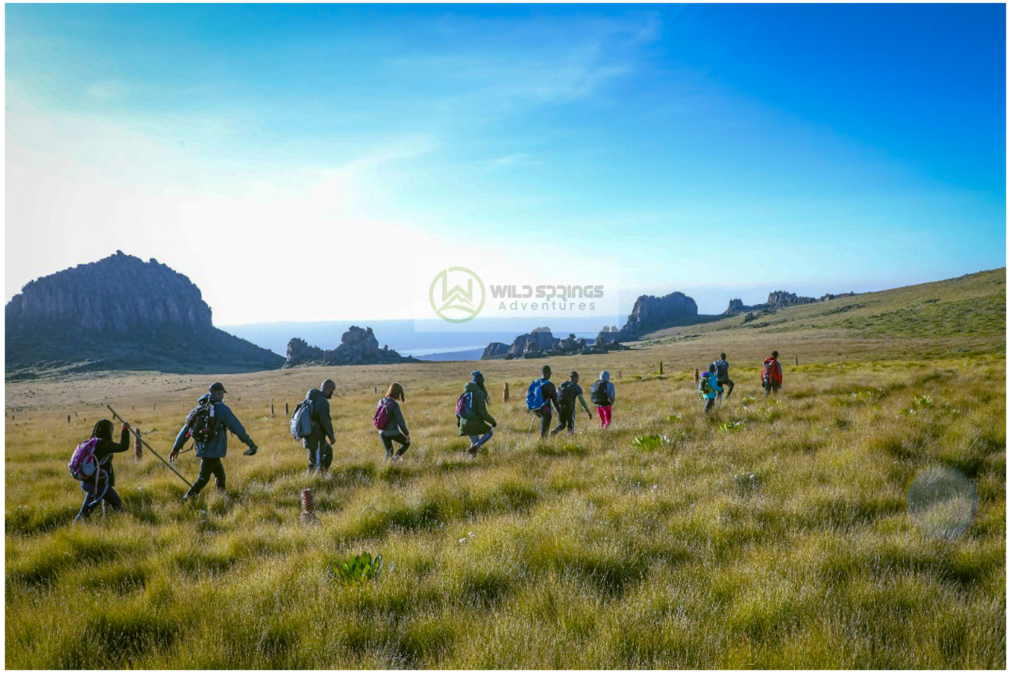
This is the most drama-free trail start in the Aberdares. You are already at 3,400m. There is no bamboo zone, no planted forest approach, no gradual build-up. You step out of the vehicle and the full Aberdare moorland is in front of you. The Twin Rocks landmark — two prominent boulders — mark the official picnic site and trailhead. Your guide briefs the group. Then you walk north.
🌾 09:00 – 11:00 · 3,400m – 3,700m · Open Moorland — Nipple Rock & The Approach
The first section is broad, open moorland walking on a gentle but sustained ascent. Tussock grass, heather, distant ridges, bogs that require stepping carefully. About 15 minutes in, the first rock formation appears: The Nipple — a smooth dome-shaped volcanic outcrop that the hikers collectively decided to name without much deliberation. Past The Nipple, the rocky formations grow more dramatic and more numerous. The trail winds through progressively larger rock groups, each one building toward the main event.
🪨 11:00 – 12:00 · ~3,700m – 3,800m · The Dragon's Teeth
The Dragon's Teeth appear in full. The most impressive rock formation on any Aberdare hiking trail — jagged spires of ancient trachyte volcanic rock that rise from the moorland floor like broken towers, some reaching 10 to 15 metres, arranged in irregular groups that the trail winds between and through. Local guides call this stretch Dragon's Pass — the corridor that runs through the formation, framed by rock walls on both sides. Standing inside the Dragon's Teeth with the summit ridge visible ahead, you understand why every hiker who has done this trail photographs this section more than any other.
The geology: these formations are composed of porphyritic quartz trachyte — ancient volcanic material that was intruded into the surrounding moorland rock, then harder and more resistant to erosion than the surrounding material, left standing as the softer rock around them wore away over millions of years. They are not glacial features. They are the exposed skeleton of a volcano.
⛰️ 12:00 – 14:00 · 3,800m – 4,001m · Final Push to Summit
Past the Dragon's Teeth, the trail rises more steeply for the final section. Rocky, boggy in places, and notably thinner in air — you are above 3,800m now, and the altitude is undeniable. The summit ridge comes into view. Two final ascents of the rocky slope, and you are there.
🏅 14:00 · 4,001m · THE SUMMIT — Ol Donyo Lesatima
The sign confirms the altitude. 4,001 metres. Kenya's third-highest mountain. The view is everything the approach promised: Mount Kenya's glaciated peaks to the east, enormous and clear on good mornings. The Rift Valley Lakes — Naivasha, Nakuru, Elementaita — glinting to the west. Laikipia's plains rolling north toward Ethiopia. Lake Ol Bolosat visible below to the north. On exceptional days in the dry season, the Mau Escarpment 150km away. Sit down, eat your lunch, and take every photograph you can before the afternoon cloud arrives.
14:30 — mandatory descent start. Afternoon weather at 4,000m is not negotiable.
⬇️ 14:30 – 17:00 · 4,001m → 3,400m · Descent
Back through the Dragon's Teeth (different light, different photographs), back across the open moorland. The descent is faster and noticeably kinder on the lungs. Back to Twin Rocks by 17:00.
Nairobi by 20:30.
🐉 What Makes the Dragon's Teeth Special
No other trail in Kenya has a geological feature like the Dragon's Teeth. Understanding what they are makes the walk through them more meaningful.
The formations are porphyritic trachyte intrusions — bodies of volcanic rock that were forced upward through the surrounding moorland rock as magma millions of years ago, then cooled and hardened underground. As the softer surrounding rock eroded over geological time, these harder intrusions were left exposed, standing above the moorland surface in their current jagged forms. The same volcanic forces that built the entire Aberdare Range created these spires — and they are the most visible, accessible evidence of that geology anywhere in the range.
Other named formations along the trail include the Lost Pyramid, Muir's Massive, Weathering Heights, and the Theater of Heaven — each one a different expression of the same volcanic material, shaped differently by the same millions of years of weathering. The trail does not just pass by these features. It goes through them, walks under them, and threads between them. It is the only hiking trail in Kenya that is as much a geological tour as it is a summit hike.
🌿 Flora Along the Trail
Both Satima routes run entirely above 3,000m — which means the flora is exclusively high Afro-alpine moorland species, with none of the bamboo or lower-forest zones found on the southern Aberdare trails.
Dragon's Teeth route: Open moorland from the first step. Giant Lobelia (Lobelia deckenii) lines the trail edge from the start, with Helichrysum spp. (everlasting flowers) and tussock grass (Deschampsia spp.) dominating the open sections. In the boggy channels between rock formations, Lady's Mantle (Alchemilla hageniae) — an Aberdare endemic — fills the wetter sections with velvety dew-collecting leaves.
Wandare route: A section of Hagenia abyssinica (African Redwood) forest on the bamboo-transition drive adds a different character before the moorland begins. The trail is slightly more sheltered, and the tussock moorland on the Wandare side is arguably less visited, which means the Dendrosenecio battiscombei (giant groundsel) and lobelia communities on the upper slopes are less disturbed.
At the summit: Giant Senecio, giant lobelia, and tussock grass dominate. The Aberdare Range's 778 recorded plant species include 63 endemic species — the summit moorland holds a disproportionate number of its rarest members.
🦁 Wildlife & Nature
Aberdare National Park is a designated Important Bird Area (IBA), home to 290+ bird species and some of Kenya's most significant large mammal populations.
On the Dragon's Teeth drive in: The park road from Rhino Gate to Twin Rocks is one of the best wildlife-viewing drives in the Aberdares. Plains zebra, waterbuck, warthog, and eland are regularly seen directly from the vehicle. Elephants and buffalo are common in the forest sections.
On the Wandare drive-in: The 15km park road through the bamboo forest has elephant and buffalo signs throughout. Occasional leopard and serval sightings on early morning transits.
| 🐾 Species | 👁️ Likelihood | 📍 Where |
|---|---|---|
| 🦓 Plains Zebra | ★★★★★ | Dragon's Teeth park road drive-in |
| 🦌 Waterbuck & Eland | ★★★★☆ | Dragon's Teeth park road, open moorland |
| 🐗 Warthog | ★★★★☆ | Park road, lower moorland sections |
| 🐘 Forest Elephant | ★★★☆☆ | Wandare bamboo drive & lower forest |
| 🦬 Buffalo | ★★★☆☆ | Both routes — forest and moorland |
| 🐒 Black-and-White Colobus | ★★★★☆ | Wandare bamboo forest drive |
| 🦁 Serval Cat | ★★☆☆☆ | Open moorland above 3,500m |
| 🦏 Black Rhino | ★☆☆☆☆ | Park Salient — present, rarely seen |
🔭 Birding on Mount Satima
- Aberdare Cisticola (Cisticola aberdare) — Kenya's true highland endemic; the Satima moorland is one of its core habitats
- Jackson's Francolin (Pternistis jacksoni) — near-endemic, heard regularly in the heather zone on both routes
- Scarlet-tufted Malachite Sunbird — follows the Giant Lobelia cycle from Dragon's Teeth to summit
- Mountain Buzzard & Augur Buzzard — soaring above the moorland on morning thermals
- Moorland Chat — conspicuous on exposed rocks throughout both routes
Log your sightings: Aberdare National Park on eBird
💰 Pricing — 2026
All costs complete. Nothing added at the gate.
| 🇰🇪 Kenyan Citizens | 🌍 East African Residents | 🌐 International |
|---|---|---|
| KES 5,250 per person | KES 5,900 per person | USD120 per person |
Group discounts apply for 5+ people. Traverse (two-vehicle) option requires a small logistics surcharge — enquire when booking.
✅ What's Included
- 🚐 Round-trip transport from Nairobi (CBD/Westlands pickup)
- 🏞️ Aberdare National Park entry fees (KWS eCitizen)
- 🚗 Vehicle park entry fees
- 🪖 Mandatory armed KWS ranger for the full day
- 🧭 Certified Wild Springs mountain guide
- 🍱 Packed lunch eaten at the summit
- 💧 Drinking water
- 🩺 Emergency first aid kit and evacuation support
❌ Not Included
- 👟 Personal hiking gear: waterproof boots, gaiters, warm layers
- 🙏 Guide & ranger tips (KES 1,000–2,000 suggested)
- 🛡️ Travel insurance (strongly recommended)
- 🚐 Second vehicle for traverse option (additional cost — enquire)
⚠️ Safety on Both Routes
⚠️ Altitude at 4,001m is Real — Even on the Gentle Route
The Dragon's Teeth route is gentle in terrain but not gentle in altitude. You are above 3,400m from your first step. The air is genuinely thin. Headache, shortness of breath, and fatigue are normal and expected. Slow pace, regular water, and immediate descent if symptoms worsen are the standard protocols. If Satima is your first hike above 3,000m, treat the altitude with respect regardless of the gentle gradient.
⚠️ Bogs on Both Routes:
Both the Dragon's Teeth plateau and the Wandare moorland have saturated bog sections. Gaiters are essential. Trekking poles give confidence on soft ground. Waterproof boots with ankle support are not optional on either route.
⚠️ Afternoon Weather Above 4,000m
Cloud moves in rapidly above 3,800m after 14:00. The mandatory descent start is non-negotiable on both routes. Wild Springs guides enforce this.
⚠️ Wildlife on the Wandare Drive
The park road through bamboo on the Wandare side has an active elephant and buffalo presence. Stay in the vehicle until you reach the trailhead. Your ranger walks between you and any wildlife encounter on the trail.
🎒 What to Bring
🥾 Footwear & Lower Body
- Waterproof hiking boots with ankle support — broken in, not new
- Gaiters — mandatory on both routes (bog terrain throughout)
- Long trousers — wind and cold above 3,500m bite bare legs
- Two hiking sock pairs
🧥 Clothing Layers
- Moisture-wicking base layer
- Insulating mid-layer — fleece or lightweight down
- Waterproof, windproof shell — the summit is exposed and cold
- Warm hat and gloves — the summit at 4,001m has real wind
- Sun hat — UV at altitude is severe on open moorland
🎒 Gear & Food
- Trekking poles — the Dragon's Teeth bog sections and Wandare descent reward them
- 2.5–3 litres of water
- Packed lunch (provided) + personal snacks
- Camera — Dragon's Teeth formations deserve good photographs
- Binoculars for the summit views and birding
- Sunscreen SPF 50+
- Personal first aid
🏪 Everything you need at the Wild Springs Outdoor Store. Ask specifically about gaiter selection and shell layers for open moorland above 4,000m
📅 When to Go
| 📆 Month | ⭐ Conditions |
|---|---|
| January | ⭐⭐⭐⭐⭐ Ideal — clear summit views, firm trail |
| February | ⭐⭐⭐⭐⭐ Ideal — best clarity of year |
| March | ⭐⭐⭐ Okay — early rains, bogs deepen |
| April | ⭐⭐ Avoid — long rains, heavy bog |
| May | ⭐ Avoid — worst conditions |
| June | ⭐⭐⭐⭐ Good — dry season starts |
| July | ⭐⭐⭐⭐⭐ Ideal |
| August | ⭐⭐⭐⭐⭐ Ideal |
| September | ⭐⭐⭐⭐ Good |
| October | ⭐⭐⭐ Variable |
| November | ⭐⭐ Risky |
| December | ⭐⭐⭐⭐ Good — rains ease |
📊 Route Comparison Summary
| 🐉 Dragon's Teeth | 🌾 Wandare | 🔄 Traverse | |
|---|---|---|---|
| Summit | 4,001m | 4,001m | 4,001m |
| Distance | ~16km | ~21km | ~27km combined |
| Elevation Gain | ~600m | ~800m | ~800m |
| Duration | 5–7 hrs | 6–8 hrs | 8–10 hrs |
| Difficulty | Moderate | Hard | Hard |
| Scenery | ⭐⭐⭐⭐⭐ | ⭐⭐⭐⭐ | ⭐⭐⭐⭐⭐ |
| Best For | First-timers, photography | Advanced, acclimatisation | Complete Satima experience |
| Logistics | One vehicle | One vehicle | Two vehicles needed |
📊 How Satima Compares to Other Aberdare Trails
| 🏔️ Trail | ⬆️ Summit | 💪 Difficulty | 🎯 Best For | ⏱️ Time |
|---|---|---|---|---|
| 🌿 Mount Kipipiri | 3,349m | Moderate | Wildflowers, history | 8–9 hrs |
| 🐘 Elephant Hill | 3,658m | Hard | First serious challenge | 7–10 hrs |
| 🪨 12 Apostles | 3,672m | Very Hard | Kenya's toughest day hike | 12–17 hrs |
| 🗻 Table Mountain | 3,817m | Moderate | Scenic, photography | 5–7 hrs |
| 💧 Seven Ponds | 3,826m | Hard | Glacial tarns, solitude | 7–10 hrs |
| 🦏 Rhino Hill | ~3,890m | Hard | Off-trail wilderness | 7–9 hrs |
| 🌾 Rurimeria Hill | 3,860m | Strenuous | Mount Kenya training | 7–10 hrs |
| ⛰️ Kinangop | 3,906m | Hard–Very Hard | Technical summit | 9–12 hrs |
| 🏅 Satima | 4,001m | Moderate–Hard | Highest Aberdare, best first 4,000m summit, Dragon's Teeth | 5–8 hrs |
Source: AllTrails — Aberdare National Park · Wild Springs guided records.
🏔️ Why Satima Before Mount Kenya
Smart climbers use Satima as a controlled test. At 4,001m, it is high enough to feel altitude genuinely — the shortness of breath, the slower pace, the slight headache if you push too fast — without the multi-day commitment and cost of a Mount Kenya expedition.
Three things Satima tells you before you book Mount Kenya:
1. How your body handles 4,000m. Everyone is different. Some people feel nothing above 3,500m. Others feel significant effects above 3,000m. Satima is the honest test. If the summit feels fine, Point Lenana is within reach. If it is hard, you know what to train.
2. Whether your gear is right. New boots, new pack, new waterproof jacket — test everything here where the consequence of failure is a bad day, not a failed expedition.
3. Whether your pacing is sustainable. Six to eight hours of sustained effort at altitude is a different experience to six to eight hours at sea level. Satima tells you where your stamina actually sits.
👥 Private & Custom Options
👥 Private Groups
All routes available on private booking — your date, your pace, your guide's full attention. Recommended for corporate teams, families with varying fitness levels, and anyone wanting the summit without managing a group of strangers.
🔄 Custom Traverse
We organise vehicle logistics for the one-way traverse. Tell us which direction you prefer — ascending Dragon's Teeth and descending Wandare gives you the geological drama as the mental reward on the way up, and a different, quieter descent. Ascending Wandare and descending Dragon's Teeth saves the best views for the second half of the day. Both work. Both are good. Contact us for logistics and pricing.
📸 Photography Groups
The Dragon's Teeth formations at different times of day, in different light conditions, are a dedicated photography objective. We can arrange earlier departures, slower pacing through the formation, and extended summit time for photography-focused groups.
🎯 Mount Kenya Preparation Programme:
Wild Springs can design a structured multi-hike programme using Satima (Dragon's Teeth or Wandare) as a key altitude training step in preparation for Point Lenana. Contact us with your expedition date, and we will build backwards from there.
🤝 Why Wild Springs
- ⭐ TripAdvisor Award Winner — real reviews from real climbers
- 🏛️ Kenya Tourism Authority Licensed — fully registered tour operator
- 🌍 TOSK Kenya Member — Tour Operators Society of Kenya
- 🧗 MCK Certified Guides — Mountain Club of Kenya; our Satima guides know both routes and the traverse logistics
- 🤝 Fair Pay — guides and rangers paid above industry standard
- 🌿 Leave No Trace — zero plastic policy, all waste carried out
🏔️ Individual Route Pages
For deeper detail on each specific route, see the dedicated pages:
🏔️ What Comes Next
Once you have stood at 4,001m, the Aberdare range is complete. The next mountain is Kenya's most iconic.
- 🏔️ Kamweti Route — Mount Kenya — the wilderness route
- 📅 Mount Kenya Group Treks 2026 — fixed departure dates across all routes
- 💪 Mount Kenya Fitness Programme — 8-week structured plan
- 🎒 Mount Kenya Gear Checklist
- 🏪 Wild Springs Outdoor Store
💳 How to Book & Pay
📱 M-Pesa Paybill
- Paybill: 4065921
- Account: Satima
After payment, WhatsApp your name, date, group size, and chosen route to confirm.
🏢 Credit Card / Cash at the Office
Valley View Office Park, Tower A, First Floor, Sixth Avenue Parklands, off Limuru Road, Nairobi
Mount Satima Contacts
📞 +254 729 257 317 · +254 734 417 496 · +254 721 957 652
Where You Will Visit
This safari explores the following regions in Kenya
- Nairobi
- Mount Satima, Nyeri