
Rurimeria Peak in Kenya’s Aberdare Range is one of the most challenging high-altitude day hikes, perfect for experienced hikers training for Mount Kenya or Kilimanjaro. Standing at 12,670 feet (3,861 m), the trail features a steep 3,280-foot (1,000 m) elevation gain over just 2.5 miles (4 km). This hike tests your physical endurance, mental strength, and ability to handle rapid altitude changes.

Key highlights:
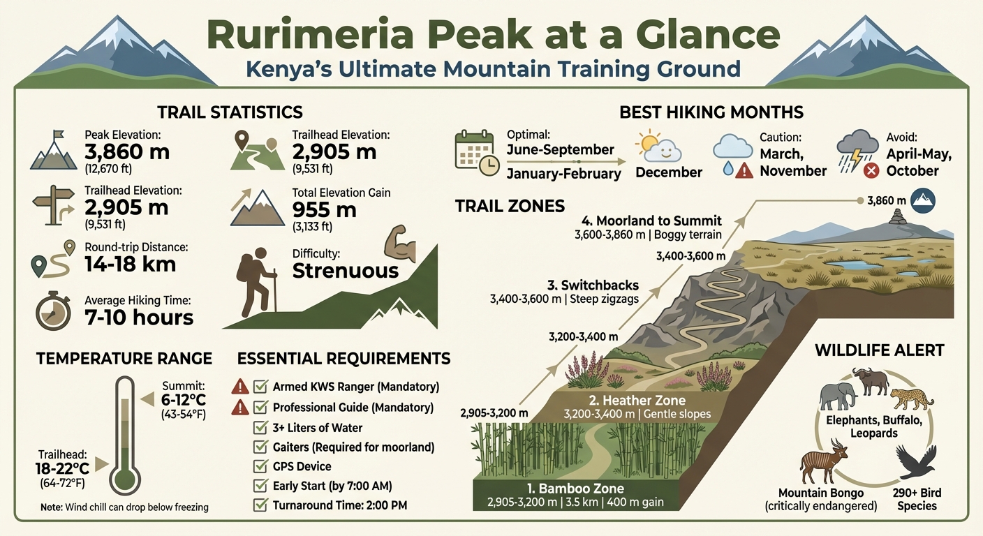
- Trail Length: 14–18 km round trip.
- Time Required: 7–10 hours.
- Difficulty: Strenuous.
- Best Months: June–September, January–February.
- Starting Point: Gathuthi Primary School, Nyandarua County.
- Wildlife: Elephants, buffalo, and rare species like the mountain bongo.
You’ll pass through bamboo forests, heather zones, and alpine moorlands, encountering steep switchbacks, boggy terrain, and unpredictable weather. An armed ranger is mandatory due to wildlife risks, and preparation is crucial for a safe, successful hike. Start early, pack layers, trekking poles, and plenty of water, and be ready for a tough but rewarding climb.
Hiking Mt. Rurimeria |Aberdare Ranges| – |3rd Highest Peak in the Aberdare Ranges| – Kenya
Quick Facts About Rurimeria Peak
Before setting out on this trail, it’s important to understand what you’re getting into. This isn’t a casual stroll – it’s a full-day climb that demands solid preparation. Rurimeria Peak is often used as a training hike for major summits like Mount Kenya and Kilimanjaro, and for good reason.
Distance, Elevation, and Time Required
The trail’s numbers speak for themselves. The round-trip distance varies between 14 and 18 km, depending on your chosen route and any detours. Starting at 2,905 m (9,531 ft) at Gathuthi Primary School, you’ll ascend to the summit at 3,860 m (12,670 ft), making for an elevation gain of about 955 m (3,133 ft). The hike typically takes 7 to 10 hours, accounting for rest stops and slower movement at higher altitudes.
| Feature | Specification |
|---|---|
| Round-trip Distance | 14–18 km |
| Peak Elevation | 3,860 m (12,670 ft) |
| Trailhead Elevation | 2,905 m (9,531 ft) |
| Total Elevation Gain | ~955 m (3,133 ft) |
| Average Hiking Time | 7–10 hours |
Difficulty Level and When to Go
This hike is rated strenuous, and that’s no exaggeration. The steep altitude gain is challenging, and the terrain ranges from slippery bamboo sections to soggy moorlands. Timing your hike is crucial. The best months are June through September and January through February, when the trails are drier, and visibility is better. Outside of these windows, you’ll likely face muddy paths, foggy conditions, and a higher chance of afternoon storms.
Trailhead Location and Ranger Requirement
The adventure begins at Gathuthi Primary School in Nyandarua County, at an elevation of 2,905 m (9,531 ft). Due to the wildlife in the Aberdares, including elephants and buffalo, an armed KWS ranger is required to accompany you. This isn’t optional, so make sure to include it in your planning and budget.
What is Rurimeria Peak?
Rurimeria Peak stands proudly within the Aberdare Range, or the Nyandarua Ranges as it’s locally known, in Nyandarua County, central Kenya. It’s the third-highest peak in the Aberdares, located just 2.9 km from Mount Satima, the range’s tallest summit. The mountain’s slopes transition from lush montane forests to alpine moorlands, creating habitats for rare wildlife like the mountain bongo – a species with fewer than 100 individuals left in the wild – alongside giant forest hogs, serval cats, and elephants.
The name Rurimeria originates from the Maasai word Olurumueria, which refers to the vegetation found at the summit. This area holds deep historical significance: during the 1950s, the Aberdare forests served as a refuge for Mau Mau freedom fighters during Kenya’s struggle for independence. Nearby, Treetops Lodge became famous as the place where Princess Elizabeth ascended to the throne in 1952. Even the name Nyandarua, meaning “drying rack”, reflects the shape of the range’s ridgeline, tying the landscape to local culture and history.
Why Rurimeria Matters for Mountain Training
Rurimeria Peak isn’t just a beautiful destination; it’s a true test for hikers. Starting at an altitude of 2,905 m (9,531 ft), the trail gains 955 m (3,133 ft) over a round trip of 14 to 18 km. This steep ascent creates a low-oxygen environment, challenging both cardiovascular and muscular endurance. For those preparing to tackle Mount Kenya or Kilimanjaro, Rurimeria offers a perfect training ground.
What makes it particularly demanding is the steep gradient right from the bamboo zone. Unlike trails that ease you into higher altitudes, Rurimeria throws you into the deep end. By the time you reach the moorland plateau, you’re already battling thinner air and fatigue. This hike pushes you to your limits, exposing weaknesses in fitness or gear, while also building the confidence needed for higher-altitude climbs.
The Aberdare Range‘s Water Tower
The Aberdare Range is one of Kenya’s five water towers, serving as a critical water source for millions. It feeds rivers that supply water to Nairobi and sustain around 4 million farmers. These rivers flow from the forests and moorlands, nourishing agricultural regions and urban areas downstream.
To protect this vital ecosystem, Rhino Ark, a conservation group, has established a 400 km conservation fence around the Aberdares. This fence not only safeguards the forests and bamboo zones but also helps mitigate human-wildlife conflict. The range is also a haven for birdlife, with over 290 species recorded, including the Aberdare Cisticola and Jackson’s Francolin, making it a designated Important Bird Area by BirdLife International.
Name Origin and Local History
The name Rurimeria, derived from the Maasai word Olurumueria, highlights the vegetation at its summit. The Aberdare Range, named after Lord Aberdare of the Royal Geographical Society, has always been known locally as Nyandarua. Its historical significance is woven into the landscape, from the Mau Mau’s use of its forests as a sanctuary to its proximity to iconic sites like Treetops Lodge.
Access to Rurimeria begins at Gathuthi Primary School in Nyandarua County, connecting the trail to local communities who have lived alongside and depended on these mountains for generations. The journey through Rurimeria isn’t just about the climb – it’s a walk through a living ecosystem, steeped in history and vital to the livelihoods of those who call it home.
The Rurimeria Trail: What to Expect on Each Section
The Rurimeria Trail is divided into four distinct stages, each with its own challenges, terrain, and scenery. As you ascend, the physical and mental demands increase, requiring careful preparation for every section.
Section 1: The Bamboo Zone (Trailhead to 1st False Summit)
Starting at Gathuthi Primary School at an altitude of 2,905 m (9,531 ft), the trail plunges you straight into a steep bamboo forest filled with Yushania alpina. This stretch, around 3.5 km long with a 400 m (1,312 ft) elevation gain, is no gentle introduction. The climb is relentless, and the ground can be treacherous – mud, decomposing bamboo leaves, and slippery patches make every step a challenge, especially after rain.
Adding to the difficulty are stinging nettles that line the narrow path. Wearing long pants and sleeves isn’t just recommended – it’s essential to avoid irritation. The bamboo canopy creates a cool, damp environment, but don’t be fooled; the effort required to push upward will leave you sweating almost immediately. This section demands strong legs and good cardiovascular fitness as you tackle the thin air right from the start.
Once you conquer the bamboo forest, the trail transitions into a less intense heather zone, offering a welcome reprieve.
Section 2: The Heather Zone (1st to 2nd Peak)
Emerging from the bamboo, you’ll find yourself in a heather-filled landscape dominated by Erica arborea. The gradient eases slightly here, giving your legs and lungs a much-needed recovery period. The open canopy allows sunlight to filter through, and for the first time, you’ll catch views of Mount Kipipiri to the west – a morale booster after the grueling bamboo climb.
The path winds gently through twisted heather trees draped in lichen, creating a calm, almost serene atmosphere. This is the perfect spot to rehydrate, catch your breath, and mentally prepare for the climb ahead. While the air continues to thin, the gentler slope helps your body adjust to the altitude.
However, this brief recovery doesn’t last long. The trail soon steepens again as it transitions into a series of demanding switchbacks.
Section 3: Switchbacks to the 3rd Peak
As you approach the third false summit, the trail becomes steeper, zigzagging through a series of switchbacks. At this point, you’re climbing above 3,500 m (11,483 ft), where the air is noticeably thinner. Every step feels heavier, and your breathing deepens as your body works harder to keep up.
From this vantage point, you can see Geta village far below – a stark reminder of how much elevation you’ve already gained. The views here are spectacular, but also serve as a checkpoint for many hikers. Altitude sickness symptoms like mild headaches, nausea, or fatigue may start to creep in. If you notice these signs, it’s crucial to slow down, hydrate, and evaluate whether you’re fit to continue.
With the switchbacks conquered, the trail shifts into the moorland zone, where the final push to the summit begins.
Section 4: The Moorland to Summit
The last stretch takes you into boggy moorland, a plateau dotted with tussock grass, Lobelia deckenii, and the towering Dendrosenecio battiscombei (giant groundsels). Trail markers, often faded red paint on rocks, guide the way, but fog and whiteout conditions – common after 2:00 PM – can make navigation tricky. A guide and GPS are essential here, as losing the trail can cost valuable time.
The ground is soft and wet, hiding pools of water that can easily soak your boots. Gaiters are a must to keep your feet dry. The final climb to the summit at 3,860 m (12,670 ft) is slow and deliberate. The thin air, combined with biting winds and dropping temperatures, makes every step a test of endurance.
At the summit, marked by a cairn, you’re rewarded with sweeping views of the Aberdare Range and even Mount Kenya – if the weather cooperates. This section is not just about physical strength but also about careful navigation and mental focus. The moorland’s challenges mirror those of Kenya’s higher peaks, making it an excellent preparation for more demanding climbs.
Difficulty Level and Fitness Requirements
Rurimeria is a challenging high-altitude hike that tests both your physical fitness and mental grit. With an elevation gain of 955 m (3,133 ft) over a relatively short distance and altitudes exceeding 3,000 m (9,843 ft), this trail pushes even seasoned hikers to their limits. Preparation is not optional – it’s essential.
Who Should (and Shouldn’t) Hike Rurimeria
Rurimeria is ideal for seasoned hikers who are used to steep climbs and high-altitude conditions. If you’ve tackled other mountain treks and are confident in your endurance, strength, and ability to handle prolonged exertion, this trail could be your next big challenge. You’ll need a solid fitness foundation, strong legs, and the determination to push through physical discomfort.
However, this hike is not suitable for beginners, young children (under 12), or individuals with heart or respiratory conditions. The high altitude and physical demands can exacerbate health issues, so it’s crucial to be in good shape. If you’ve never hiked above 3,000 m (9,843 ft) before, it’s best to gain experience on less demanding trails first.
How to Prepare Physically
Start training for Rurimeria at least 4–6 weeks before your hike. Focus on improving cardiovascular endurance with activities like running, cycling, or swimming. Aim for 3–4 sessions per week, including at least one longer workout lasting 60–90 minutes. Strengthen your legs with exercises like squats, lunges, step-ups, and stair or hill climbs. To mimic the hike’s conditions, practice carrying a loaded daypack on steep terrain.
Acclimatization is just as important. Plan a warm-up hike at a moderate altitude – Ngong Hills or Longonot are excellent options – about a week or two before your Rurimeria trek. Be aware of altitude sickness symptoms such as headaches, nausea, and dizziness, and pace yourself carefully while staying hydrated. With a solid training plan, you’ll be better equipped to handle Rurimeria’s steep inclines and high elevations.
How Rurimeria Compares to Other Trails
Rurimeria is more challenging than Elephant Hill, thanks to its steeper inclines and quicker altitude gain. It’s on par with Kinangop Peak, making both trails excellent preparation for tougher summits like Mount Kenya or Kilimanjaro. If you’ve completed Elephant Hill without much difficulty, Rurimeria is a logical next step. However, if you found Elephant Hill overwhelming, you might want to work on your fitness before attempting Rurimeria.
Plants, Animals, and Birds You’ll See
The natural beauty of Rurimeria isn’t just about the challenging trails – it’s also about the incredible plants and wildlife you’ll encounter along the way. The hike takes you through four distinct vegetation zones: montane forest, bamboo, heath, and afro-alpine moorland. Each zone offers its own unique plant life, making the journey as visually stunning as it is demanding.
In the montane forest, towering trees like Ocotea usambarensis and Juniperus procera dominate the landscape, creating a lush, green canopy. As the trail climbs, the forest gives way to dense bamboo thickets, where the undergrowth can make navigation tricky. Higher up, the terrain shifts into the heath zone, where gnarled Erica arborea trees thrive in the thinner air. Finally, at the highest elevations, you’ll reach the afro-alpine moorland, a rugged area dotted with hardy plants like Lobelia deckenii, Dendrosenecio battiscombei, and Senecio keniensis var. aberdaricus, nestled among tussock grasses and boggy patches.
Vegetation Zones from Forest to Alpine
| Zone | Elevation Range | Key Species |
|---|---|---|
| Montane Forest | 2,905–3,200 m (9,530–10,500 ft) | Ocotea usambarensis, Juniperus procera |
| Bamboo | 3,200–3,400 m (10,500–11,155 ft) | Yushania alpina |
| Heath | 3,400–3,600 m (11,155–11,811 ft) | Erica arborea |
| Afro-Alpine Moorland | 3,600–3,860 m (11,811–12,670 ft) | Lobelia deckenii, Dendrosenecio battiscombei, Senecio keniensis var. aberdaricus |
But the plants are just the beginning. Rurimeria’s wildlife is just as captivating as its flora.
Wildlife on the Trail
The Aberdare Range is home to some of Kenya’s most elusive creatures. Along the trail’s lower sections, you might come across elephants, buffalo, giant forest hogs, or playful colobus monkeys. If you’re lucky, you could even spot rare predators like leopards, serval cats, or hyenas. One of the most extraordinary residents of these forests is the mountain bongo, a critically endangered antelope. With fewer than 100 individuals remaining in the wild, spotting one is a rare privilege. However, the presence of large and unpredictable animals like elephants and buffalo underscores the importance of hiking with an armed KWS ranger.
The wildlife here isn’t just about mammals. The Aberdares are also a haven for bird enthusiasts.
Bird Species and Conservation Status
The Aberdare Range is recognized as an Important Bird Area by BirdLife International, boasting an impressive 290 bird species. Among these are endemic and near-endemic species such as the Aberdare Cisticola, Jackson’s Francolin, and the striking Scarlet-tufted Malachite Sunbird. The diverse habitats, from dense forests to open moorlands, make the trail a rewarding experience for birders. This rich avian diversity also highlights the importance of protecting these ecosystems, ensuring that future generations can enjoy the wonders of the Aberdares.

Weather Patterns and Best Hiking Months
Rurimeria’s weather is famously unpredictable. The micro-climate of the Aberdare Range can shift dramatically – clear skies can quickly give way to dense fog, impacting both safety and your chances of reaching the summit. Much like its rugged terrain, Rurimeria’s weather demands careful preparation and respect.
Month-by-Month Hiking Conditions
The dry months from June to September and January to February are your best bet for a successful hike. During these periods, mornings are usually clear, giving you stunning views of Mount Kenya and the Rift Valley, while the trails remain firm and easy to navigate. December is generally dry but may bring occasional afternoon showers. March and November are less predictable, with a higher chance of intermittent rain. Avoid April, May, and October, as heavy rains during these months make trails slippery, visibility poor, and hiking conditions dangerous.
| Period | Conditions | Trail Status |
|---|---|---|
| June–September | Clear skies, minimal rainfall | Excellent visibility, firm trails |
| January–February | Dry, stable weather | Ideal for summiting |
| December | Mostly dry, occasional showers | Generally favorable |
| March, November | Some rain, unpredictable weather | Muddy trails, reduced visibility |
| April–May, October | Heavy rains, dense fog | Slippery and unsafe conditions |
Temperature Changes by Elevation
With a 1,000-meter climb over just 4 kilometers, temperatures drop sharply as you ascend. At the Gathuthi trailhead (2,905 m / 9,530 ft), temperatures typically range from 64–72°F (18–22°C). However, by the time you reach the summit at 3,860 m (12,670 ft), the temperature drops significantly, ranging from 43–54°F (6–12°C). Add wind chill to the mix, and it can feel even colder – sometimes below freezing. The exposed moorland near the summit offers little protection from the wind, making the final stretch particularly challenging. This steep temperature change highlights the importance of dressing in layers and being prepared for sudden shifts in weather.
Weather Risks and Turn-Around Time
Afternoon fog is almost guaranteed on Rurimeria. After 2:00 PM, clouds roll in quickly, drastically reducing visibility. To ensure safety, a mandatory turnaround time of 2:00 PM is recommended. Cold, wet conditions combined with altitude can lead to risks like hypothermia and disorientation. Starting your hike early – ideally by 6:00 AM – is crucial to complete the trek within a safe time frame. Proper gear, which we’ll cover in an upcoming checklist, is essential for navigating these challenges and ensuring a safe return.
What to Bring: Gear Checklist
Heading to Rurimeria requires careful planning and packing. With its rapid altitude changes, unpredictable weather, and boggy terrain, having the right gear can make all the difference. The right equipment will keep you warm, dry, and safe while tackling the steep ascents and rugged trails.
Clothing and Footwear
Start with sturdy, waterproof hiking boots that provide solid ankle support. Pair them with gaiters to keep your feet and lower legs dry, as the trail includes steep bamboo slopes, muddy heather patches, and waterlogged bogs. Traction is key for navigating these challenging sections.
“Wear sturdy hiking shoes for better traction on the trails.” – Evendo
Dress in layers to adapt to fluctuating temperatures. Use a moisture-wicking base layer (synthetic or merino wool), an insulating mid-layer (like fleece or lightweight down), and a waterproof, windproof shell for protection against rain and wind. Don’t forget to pack a warm hat, gloves, sunglasses, a sun hat, and sunscreen – UV exposure increases significantly at higher altitudes.
Navigation and Safety Equipment
Altitude and unpredictable weather can pose risks like hypothermia and disorientation, so having the right safety tools is critical. Trekking poles are a must – they’ll ease the strain on your knees during steep climbs and descents. A GPS device is highly recommended, as trail markers can fade, and fog can make navigation tricky. A headlamp with extra batteries is essential for any delays, and a first aid kit stocked with blister treatments and personal medications is a non-negotiable. Lightweight but lifesaving, an emergency space blanket or bivy is worth including for sudden weather changes.
“Headlamps are the preferred light source because they are hands-free.” – National Park Service
Food and Water
Hydration and energy are crucial for tackling Rurimeria’s demanding trails. Bring at least 3 liters (100 oz) of water, as there are no reliable water sources along the route. The combination of altitude and physical exertion increases the risk of dehydration. Pack high-energy snacks like trail mix, nuts, chocolate, or energy bars to keep your energy levels steady. A full lunch is also essential, as there are no food facilities on the trail. If you time it right, the summit offers a stunning spot for a well-earned picnic.
“Bring plenty of water and snacks, as facilities are limited.” – Evendo
Safety: Altitude, Wildlife, and Navigation
Rurimeria is one of Kenya’s most challenging preparation hikes for Mount Kenya and Kilimanjaro. Tackling this trail requires careful attention to safety. Overlooking key risks can quickly lead to dangerous situations.
Altitude Sickness: Symptoms and Prevention
Starting at 2,800 m (9,186 ft) and climbing to 3,861 m (12,670 ft), this hike gains 1,000 m (3,281 ft) in just 4 km (2.5 mi). The steep ascent significantly reduces oxygen levels, leaving little room for your body to adjust.
“Within 4km of hiking, you go up to 1 km altitude gain. This makes a huge difference in the oxygen content in the air, making the hike even difficult.” – New Biochemist, Guide, Hikers Afrique
Be alert for signs of acute mountain sickness (AMS), which often occur above 3,000 m (9,843 ft). Common symptoms include headaches, nausea, and dizziness. To reduce your risk, ascend at a steady pace, drink at least 3 liters of water during the hike, and resist the urge to rush. If symptoms appear, stop to rest and hydrate. Should they worsen – such as confusion, severe headaches, or trouble breathing – descend immediately, as AMS cannot be treated at higher altitudes.
Altitude isn’t the only challenge on this trail – wildlife adds another layer of complexity.
Wildlife Safety and Ranger Requirements
The Aberdares’ unpredictable weather and diverse wildlife make safety precautions non-negotiable. An armed KWS ranger is mandatory for this hike. The region is home to potentially dangerous animals, including elephants, buffaloes, leopards, hyenas, giant forest hogs, and the critically endangered mountain bongo. Elephants and buffaloes, in particular, can act unpredictably and become aggressive if startled.
Stick with your group, follow the ranger’s instructions, and stay on designated trails. In the event of an encounter with large wildlife, remain calm, avoid sudden movements, and back away slowly. Your guide or ranger will handle the situation, but your cooperation is crucial.
Navigation Challenges and Weather Risks
Above 3,500 m (11,483 ft), the moorland section introduces serious navigation difficulties. Trail markers may be hard to spot, and tussock grass can obscure the path. Adding to this challenge, the Aberdares’ micro-climate can shift suddenly, bringing dense fog or even whiteout conditions. In such low-visibility terrain, disorientation becomes a real threat.
Always hike with a guide. Navigating solo in these conditions is extremely dangerous. Carry a GPS device as a backup, and ensure your guide is familiar with the route’s landmarks. Starting early – preferably by 8:00 AM – gives you enough time to finish the hike before afternoon fog rolls in.
How to Book Your Rurimeria Hike
Once you’ve got your gear and safety measures sorted, it’s time to lock in your adventure to Rurimeria Peak. Wild Springs Adventures offers two booking options: one for those who enjoy group experiences and another for hikers seeking a private, tailored trek.
Group Departure Option
For a shared mountain experience, group hikes are available on scheduled weekends at KES 4,500 (about US$35) per person. These hikes bring together individuals who might be training for bigger climbs or testing their endurance at altitude. You can check upcoming dates and reserve your spot on the Book Rurimeria Group Hike page. Make sure to book several days ahead to allow time for arranging transport from Nairobi and the required KWS ranger. If the fixed schedule doesn’t work for you, take a look at the Private Trek Option below.
Private Trek Option
For more flexibility and a personalized experience, private treks start at US$195 per person. This option is perfect for families, small groups, or those who prefer to hike at their own pace. You can request custom departure dates through the Private Rurimeria Trek page. Private bookings let you tailor the timing and logistics to your needs while maintaining the same safety protocols, including the mandatory ranger. This option is ideal for experienced hikers who value a customized schedule and are ready for the challenges of Rurimeria Peak.
What’s Included and What to Bring
No matter which option you choose, both packages include round-trip transport from Nairobi, Aberdare National Park entry fees, an armed KWS ranger, a professional guide, and emergency first aid support. However, meals, personal hiking gear (like boots, gaiters, clothing, and trekking poles), and optional tips for your guide and ranger are not included. Make sure to pack at least 3 liters of water, as there are no facilities on the trail or at the summit.
Once your booking is confirmed, double-check your gear and safety checklist to ensure you’re ready for this demanding yet rewarding adventure.
Frequently Asked Questions
Here are answers to some of the most common questions about the Rurimeria hike, providing additional details to help you prepare.
Is Rurimeria Harder Than Elephant Hill?
Yes, Rurimeria is more challenging than Elephant Hill. Its steep ascent leads to a quicker drop in oxygen levels, and the trail has more exposed moorland sections. If you’ve conquered Elephant Hill, Rurimeria is a logical next step – but be ready for a much tougher climb.
Can Beginners Hike Rurimeria?
No. Rurimeria is not suitable for beginners. The hike is strenuous, with a steep incline and high altitudes that require prior mountain experience. Understanding how your body reacts to elevation is crucial. Children under 12 and individuals with heart or respiratory issues should avoid this hike.
What Fitness Level Do I Need?
You’ll need strong cardio endurance and leg strength to tackle Rurimeria. The hike involves 7–10 hours of effort, steep climbs, uneven terrain, and thinner air at higher altitudes. Training with activities like trail running, stair climbing, or uphill hikes with a weighted pack can help. If you can handle 5–6 hours of continuous exertion on moderate terrain, you’re likely ready for this trail.
How Long Does the Hike Take?
The hike typically takes 7–10 hours round trip, depending on your pace, fitness level, and weather. Well-acclimatized hikers may finish in about 7 hours, while those affected by altitude might need closer to 10. The final ascent to the summit usually takes 1.5 to 2 hours. Keep in mind the 2:00 PM turnaround cutoff, which helps avoid late-day fog and darkness.
What Should I Wear and Bring?
Pack the following essentials:
- Waterproof high-ankle boots
- Gaiters
- Trekking poles
- Layered clothing (including a waterproof shell)
- Gloves, a warm hat, and a sun hat
- Sunglasses and sunscreen
- Headlamp
- First aid kit
- At least 3 liters of water
- Snacks and a packed lunch
Temperatures range from 64–72°F (18–22°C) at the trailhead to 43–54°F (6–12°C) at the summit, with the potential to dip below freezing.
Are Gaiters Required?
Yes, gaiters are mandatory for the final moorland section, which is often wet and muddy. If you don’t own a pair, you can rent them through the Gear Rental page.
Will I Get Altitude Sickness?
There’s a real risk of altitude sickness on Rurimeria. The hike starts at 2,905 m (9,530 ft) and climbs to 3,860 m (12,670 ft), an altitude where symptoms like headache, nausea, and dizziness are common. To minimize risks, spend a day or two acclimatizing at a moderate altitude, stay hydrated (about 0.5 L of water per hour), and avoid alcohol. If symptoms worsen, descend immediately.
What About Dangerous Animals?
The Aberdare Range is home to elephants, buffalo, hyenas, and other wildlife. For safety, an armed KWS ranger is mandatory on every hike. Stick to marked paths, avoid sudden movements, and follow your ranger’s instructions to stay safe.
Do I Need a Guide and Ranger?
Yes, you’ll need both a guide and an armed KWS ranger. Navigating the trail can be tricky due to faint markers and sudden fog in the moorland. These professionals ensure both your safety and proper navigation.
What’s the Best Month to Go?
The best times to hike Rurimeria are June–September and January–February, when the weather is clearer and the trail conditions are better. December can also be favorable. Avoid April, May, and October, as heavy rains and fog make the trail more difficult.
How Much Does It Cost?
- Group hikes: KES 4,500 (around $35) per person
- Private treks: Start at $195 per person
Both options include round-trip transport from Nairobi, Aberdare National Park entry fees, an armed KWS ranger, a guide, and emergency first aid. Meals, personal gear, and tips are not included. For the latest pricing and availability, visit the Book Rurimeria Group Hike or Private Rurimeria Trek pages.
Can I Drive Myself to the Trailhead?
While it’s technically possible, it’s not recommended. The trailhead at Gathuthi Primary School is accessed via a rough dirt road off the C69 near Ol Kalou, and the last stretch is best done on foot. If you opt for public transport, a matatu from Njabini to Ol Kalou costs about 100 KES, and a taxi from Ol Kalou to the trailhead ranges from 500 to 1,000 KES. Organized transport through Wild Springs Adventures is a more convenient option, ensuring you meet your ranger on time and at the right location.
🏔️ Related Hikes and Training Programs
Build Your Foundation: Start Smart 🥾
Rurimeria Peak is a fantastic training ground for ambitious hikers preparing for bigger mountains like Mount Kenya or Kilimanjaro. But before you jump straight into its steep climbs and high-altitude challenge, it’s important to understand where it fits within your hiking journey. Think of Rurimeria as a bridge between beginner-friendly hikes and serious alpine trekking—a place where your body begins to adapt and your confidence starts to grow.
If you’re just getting started, Elephant Hill is the perfect entry point into the Aberdare ecosystem. It’s less aggressive in elevation gain and offers a smoother introduction to altitude hiking. Many hikers use it as a standalone summit experience, while others combine it with Mount Kinangop routes for progression. Once you’ve comfortably handled Elephant Hill, stepping up to Rurimeria feels like a natural evolution—expect steeper climbs, thinner air, and a more demanding pace. It’s where things start getting real.
Level Up: Expanding Your Aberdare Experience 🌄
Once you’ve begun exploring the Aberdares, the variety of trails opens up your training possibilities. For hikers targeting Kinangop, the Mutarakwa Trail offers a completely different terrain profile and scenic experience, adding depth to your mountain exposure. These trails don’t just give you more options—they help you build adaptability, which is crucial when preparing for unpredictable mountain conditions.
Looking to push even further? Mount Satima (Oldonyo Lesatima) stands as the highest point in the Aberdare Range at approximately 4,001 meters. This is your next serious milestone if you’re aiming to increase altitude tolerance. Other nearby options like 7 Ponds are excellent for acclimatization, while Dragon’s Teeth offers a unique volcanic rock landscape just 11.5 km away. For a mix of steep climbs and biodiversity, Table Mountain adds both physical challenge and ecological diversity to your training plan.
Structured Training: From Aberdares to Big Mountains 🎯
If you prefer a more guided and strategic approach, structured programs can accelerate your progress significantly. Wild Springs Adventures offers a Mount Kenya Training Program designed to integrate Aberdare hikes with multi-day treks. This allows you to gradually build endurance while adjusting to altitude in a controlled and progressive way.
Planning a focused weekend training session? Pairing Rurimeria with Mount Kipipiri (3,349 m) is a powerful combination. Located just 11.1 km away, this pairing gives you high-altitude exposure without overwhelming your body, making it ideal for building endurance within a manageable timeframe. By combining these hikes intelligently, you’re not just exploring—you’re training with purpose.
Preparing for Your Rurimeria Adventure
Understand the Challenge First ⚠️
Tackling Rurimeria Peak is no walk in the park—it’s a serious physical and mental test. With a 1,000-meter vertical gain packed into just 4 kilometers, the trail demands respect from the very beginning. The climb is relentless, and as you ascend, you’ll feel the air thinning while your legs begin to fatigue much earlier than expected. This isn’t just about reaching the summit—it’s about sustaining effort over a demanding terrain that doesn’t ease up easily.
What makes Rurimeria particularly challenging is not just the gradient, but the psychological aspect of the climb. The infamous false summits can play tricks on your mind, making you think you’ve reached the top when there’s still more to go. This is where mental resilience becomes just as important as physical fitness. You’ll need to stay focused, pace yourself, and push through moments where giving up feels easier than continuing.
Train Smart: 4–6 Weeks Preparation Plan 💪
Preparation is everything. Ideally, you should begin training 4 to 6 weeks before your hike. Focus on building cardiovascular endurance through activities like hill sprints, stair climbing, jogging, or weighted hikes. Strength training—especially for your legs and core—will also make a huge difference when tackling steep inclines and uneven terrain.
But don’t overlook the mental side of preparation. Rurimeria is as much a mental challenge as it is physical. Training your mind to stay calm under fatigue, to keep moving when you’re uncomfortable, and to make smart decisions when energy drops is key. At the same time, knowing your limits is just as important—there’s no shame in turning back if conditions or your body demand it. Smart hikers finish strong because they respect both the mountain and themselves.
Logistics & Gear: Plan Like a Pro 🧭
Once your body is ready, it’s time to plan the details. Start your hike early – aim to hit the trailhead by 7:00 AM. This gives you the best chance to avoid afternoon fog, make the most of the daylight, and stick to the 2:00 PM turnaround time. Book an armed KWS ranger in advance through Wild Springs Adventures, and sort out transportation from Nairobi or Ol Kalou ahead of time. The night before, pack essentials like high-energy snacks, waterproof layers, gaiters, trekking poles, and a GPS device. Double-check your first aid kit and headlamp, even if you expect to finish in daylight, and ensure you’re carrying enough water to stay hydrated.
Respect the Mountain: Leave No Trace 🌿
Equally important is respecting the environment. Stick to the Leave No Trace principles: stay on marked trails, pack out all your trash, and give wildlife the space it needs. The Aberdares are more than just scenic – they’re a critical water source for millions of people and farms downstream. Every hiker has a role in protecting this fragile ecosystem.
Rurimeria will test your limits, but with honest preparation, respect for the mountain, and careful pacing, the payoff is spectacular. The views from the summit, stretching over the Nyandarua Range and Mount Kenya, make every grueling step worth it.