Mount Mtelo: Hiking Kenya’s Fifth-Highest Mountain (Sacred Peak of the Pokot)
Mount Mtelo: Hiking Kenya’s Fifth-Highest Mountain (Sacred Peak of the Pokot)
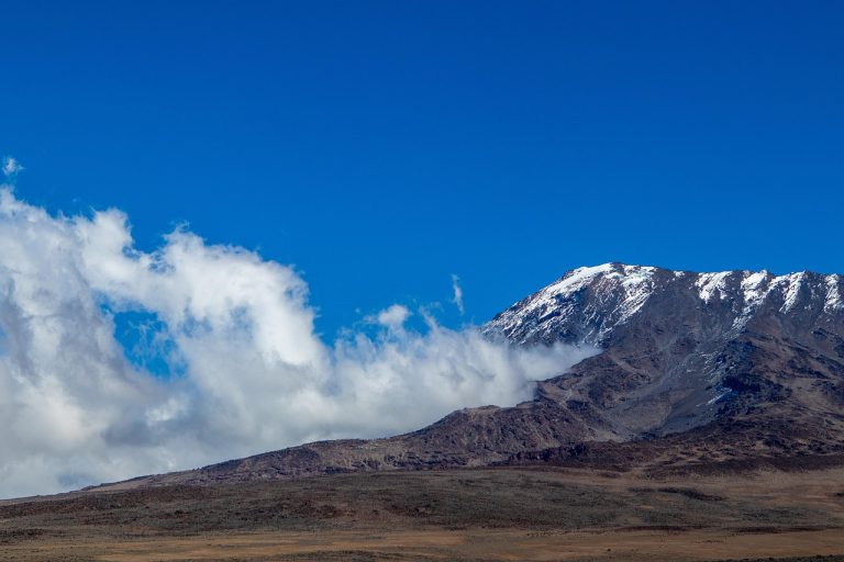
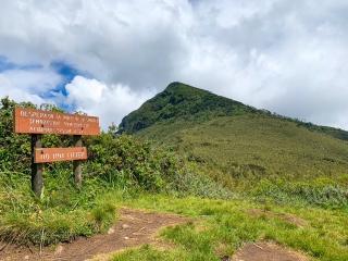
Mount Mtelo (also called Sekerr) is a 3,336-metre (10,944 ft) mountain in West Pokot County, north-western Kenya, about 120 km north of Kitale. It is popularly ranked as Kenya’s fifth-highest mountain after Mount Kenya, Mount Elgon, the Aberdare Range (Mount Satima) and the Cherangani Hills. Mtelo is the sacred mountain of the Pokot people, and its trail — farmland, riverine forest, bamboo and open moorland — is one of the least-crowded multi-day hikes in Kenya. A typical trek takes 2–3 days from Marich Pass, needs no technical climbing equipment, and rewards you with views stretching into eastern Uganda and towards Lake Turkana on clear days.
Table of Contents
- Quick Facts: Mount Mtelo
- Key Takeaways
- Where Is Mount Mtelo?
- How High Is Mount Mtelo — and Is It Really Kenya’s Fifth-Highest?
- The Sacred Mountain of the Pokot
- Hiking Mount Mtelo: Route and 3-Day Itinerary
- Wildlife and Vegetation on Mount Mtelo
- Equipment and Training for the Climb
- Best Time to Hike Mount Mtelo
- Costs, Guides and Logistics
- Common Mistakes to Avoid
- Frequently Asked Questions
- Related Treks with Wild Springs Adventures
Quick Facts: Mount Mtelo
| Fact | Detail |
|---|---|
| Elevation | 3,336 m (10,944 ft) |
| Other name | Sekerr (the massif is often called the Sekerr Range) |
| Location | West Pokot County, Kenya — about 120 km north of Kitale, near Marich Pass on the A1 Kitale–Lodwar road |
| Rank in Kenya | Popularly cited as the 5th-highest mountain (see ranking note below) |
| Cultural status | Sacred mountain and prayer site of the Pokot people |
| Trek duration | 2–3 days round trip from Marich Pass |
| Difficulty | Moderate; long summit day, no technical climbing |
| Park authority | Community land — not a KWS national park; local guides required by courtesy and for navigation |
| Main activities | Hiking, birdwatching, camping, Pokot cultural visits |
Key Takeaways
- Mount Mtelo stands at 3,336 m and is widely regarded as Kenya’s fifth-highest mountain.
- The mountain is sacred to the Pokot people, who gather there to pray, especially during drought.
- The standard route starts near Marich Pass (about 950 m), climbing through trading centres and forest to the moorland summit — a big altitude gain, so plan 2–3 days.
- No ropes or technical mountaineering skills are needed, but you need good fitness, layered clothing and rain protection.
- There are no KWS gate fees; access is arranged through the local community, which makes a local guide essential.
Where Is Mount Mtelo?
Mount Mtelo rises from the north-western highlands of Kenya in West Pokot County. The mountain sits roughly 120 km north of Kitale town and around 480–500 km from Nairobi by road, depending on your route. The usual approach is the A1 highway from Kitale through Makutano (Kapenguria) and down the dramatic Marich Pass, where the highlands drop towards the Turkwel basin and the dry country that continues to Lodwar and Lake Turkana.
The trailhead area lies near Marich Pass, at about 950 m above sea level. From here the mountain climbs almost 2,400 vertical metres — a bigger ascent than many hikers expect from a 3,336 m peak, and the main reason Mtelo deserves respect despite its modest height on paper. The West Pokot County Government lists Mtelo among the county’s flagship attractions alongside Nasolot Game Reserve, Turkwel Dam and the Kapenguria Museum, so a Mtelo trek combines easily with a wider West Pokot circuit.
Getting there from Nairobi: drive or take a bus to Kitale (the gateway town for western Kenya’s mountains), then continue by road towards Lodwar as far as the Marich Pass area. Wild Springs Adventures arranges private transport from Nairobi or Kitale as part of a custom trek package — see the contact page to plan dates.
How High Is Mount Mtelo — and Is It Really Kenya’s Fifth-Highest?
Mount Mtelo’s summit is 3,336 m (10,944 ft) above sea level. You will sometimes see 3,338 m quoted (including in older versions of this article) — the county government, topographic databases and most references agree on 3,336 m.
The popular ranking of Kenya’s highest mountains runs:
- Mount Kenya — 5,199 m (Batian Peak)
- Mount Elgon — 4,321 m (Wagagai, on the Uganda side; Koitobos is the highest point reached from Kenya)
- Mount Satima (Aberdare Range) — 4,001 m
- Cherangani Hills — about 3,530 m at their highest point
- Mount Mtelo — 3,336 m
An honest note for the detail-minded: strict peak lists that count every named summit separately (for example, treating Mount Kipipiri’s 3,349 m as its own mountain rather than part of the Aberdare massif) can push Mtelo to sixth or seventh place. What is not in dispute is Mtelo’s topographic prominence — the mountain towers alone above the surrounding lowlands with a prominence of roughly 1,766 m, which places it among the most prominent peaks in Kenya. On the ground, that isolation is exactly what makes the summit views so vast.
The Sacred Mountain of the Pokot
Mtelo is to the Pokot what Mount Kenya is to the Kikuyu: a holy mountain. Oral tradition describes the Sekerr massif as the cradle of the pastoral Pokot, and several clans — among them the Chapin, Kamket, Ngusurot, Silokot, Talai and Tungo — trace their homes to its slopes. During prolonged droughts, elders and community members climb the mountain to pray for rain, and the summit area is treated as a place of worship.
For visitors this matters in two practical ways. First, always hike with a local guide — it is both the respectful way to visit a sacred mountain and the practical way to navigate a trail with few signposts. Second, ask before photographing people, ceremonies or homesteads. The cultural welcome in Pokot country is warm and genuine, and treks here directly support village guides, porters and homestay-style accommodation. If the spiritual side of Kenya’s mountains interests you, read our companion piece on why Mount Kenya is sacred.
Hiking Mount Mtelo: Route and 3-Day Itinerary
The standard route begins near the Marich Pass Field Studies Centre (about 950 m) just off the A1, and climbs south-east through trading centres, farmland and forest to the moorland summit. Most groups take three days; strong hikers acclimatised to altitude sometimes do it in two.
Day 1: Marich Pass to the mid-mountain villages (~1,950 m)
A half-day walk of roughly 15 km (about 4–6 hours) through Pokot farmland and small trading centres, gaining about 1,000 m. Overnight at a community camp or basic lodge on the mountain’s shoulder, arranged through your local guide team. Afternoon village walks and birdwatching are the highlights here.
Day 2: Summit day (3,336 m) and return to camp
The long day: an 8–10 hour round trip through forest, bamboo and open moorland to the summit. Start at first light — the lower slopes get hot by mid-morning, and afternoon cloud can swallow the views. From the top you look west into Uganda, north towards the Turkwel basin and Lake Turkana country, and south along the Cherangani Hills.
Day 3: Descend to Marich Pass
A knee-testing descent back to the trailhead (3–5 hours), with time to visit Marich Pass or continue to Nasolot Game Reserve or Turkwel Dam before the drive back to Kitale.
Operator’s note: treat Mtelo as a remote trek, not a day hike. Phone coverage is patchy, rescue infrastructure is minimal, and the altitude gain from trailhead to summit is close to 2,400 m — more than most Mount Kenya route days. Build in a buffer day if you can.
Wildlife and Vegetation on Mount Mtelo
Mtelo’s slopes stack four distinct habitat bands, and the wildlife changes with each:
- Cultivated lower slopes (950–1,900 m): maize and bean farms, fig trees and riverine bush — good for sunbirds, weavers and hornbills.
- Montane forest (roughly 1,900–2,700 m): home to black-and-white colobus monkeys, small forest antelope such as duikers, and turacos — three turaco species have been recorded on the mountain.
- Bamboo zone: a shaded, atmospheric belt where you may hear more than you see.
- Open moorland and summit: raptors riding the thermals, chats and some of the roughly ten sunbird species recorded across the massif.
Birdwatching is genuinely excellent — bring binoculars. Big game is largely absent from the mountain itself, which keeps the walking relaxed; for elephants and buffalo, pair the trek with nearby Nasolot Game Reserve, and for the rare sitatunga antelope, Saiwa Swamp National Park near Kitale is a worthwhile stop on the drive up. If mountain fauna is your thing, see our guide to the animals seen on Mount Kenya treks for comparison.
Equipment and Training for the Climb
Mount Mtelo needs no ropes, harnesses or technical training — it is a strenuous walk, not a climb. That said, the combination of heat on the lower slopes and cold, wet moorland up high means layering matters. Our recommended kit:
- Broken-in hiking boots with good grip (see our guide to the best hiking shoes)
- 30–40 L daypack, plus a duffel if porters carry overnight kit
- Base layers, a warm fleece or light down jacket for the summit morning, and a waterproof shell or poncho
- Sun hat, sunscreen and 2–3 litres of water capacity — the lower slopes are hot and exposed
- Sleeping bag (comfort rating around 0–5 °C for mid-mountain nights), headlamp, basic first-aid kit and any personal medication
- Water purification (tablets or filter) — refill points are streams and village sources
Everything on this list is available to buy or rent from our Nairobi mountain gear store — here is what the shop stocks. For a fuller packing framework, our Mount Kenya gear checklist covers the same layering logic at higher altitude.
Training: if you can comfortably hike 6–8 hours with 1,000 m of ascent, you are ready for Mtelo. Day hikes such as Mount Satima or Mount Kipipiri in the Aberdares are ideal preparation, and our beginner trekking preparation guide covers fitness, pacing and hydration basics.
Best Time to Hike Mount Mtelo
The most reliable trekking windows in this part of Kenya are the dry seasons: roughly December to early March and June to September. The long rains (around March–May) make the forest trail slippery and the rivers high, while short rains (October–November) are usually lighter but less predictable. West Pokot spans semi-arid lowlands and wet highlands, so conditions on the mountain can differ sharply from the valley below — check the Kenya Meteorological Department county forecasts for West Pokot before you travel, and expect afternoon cloud on the summit in any season.
Costs, Guides and Logistics
Unlike Mount Kenya or Mount Elgon, Mtelo is not a gazetted national park, so there are no KWS conservation fees at a gate. Your main costs are:
- Transport: Nairobi–Kitale–Marich Pass by private vehicle or public transport (Kitale is the practical staging town).
- Local guides and porters: arranged through the trailhead community — budget for daily guide/porter wages and a fair tip.
- Accommodation: basic mountain camps/lodges on the route and simple guesthouses at Marich Pass; camping kit widens your options.
- Food and water: stock up in Kitale or Makutano; supplies on the mountain are limited.
Wild Springs Adventures runs Mount Mtelo as a private, on-request trek — we quote per group once dates, group size and transport are agreed, and we handle community liaison, guides, meals and logistics. Contact us for a tailored quote, or learn more about how we run our treks.
Common Mistakes to Avoid
- Treating Mtelo as “only” 3,336 m. The trailhead is at ~950 m — the total ascent rivals a Mount Kenya summit push.
- Attempting it without a local guide. The trail is unsignposted community land and a sacred site; a guide is essential for navigation, courtesy and safety.
- Starting the summit day late. Heat builds fast low down and cloud builds fast up high; alpine starts win here.
- Carrying too little water for Day 1. The lower farmland section is hot and exposed.
- Skipping rain protection in the “dry” season. Highland weather in West Pokot is a law unto itself.
- Rushing back to Nairobi. You are already in one of Kenya’s least-visited counties — Nasolot, Turkwel Dam, Saiwa Swamp and the Kapenguria Museum are all nearby.
Frequently Asked Questions
How high is Mount Mtelo?
Mount Mtelo is 3,336 m (10,944 ft) above sea level, in West Pokot County, Kenya.
Is Mount Mtelo the fifth-highest mountain in Kenya?
By the popular ranking — Mount Kenya, Mount Elgon, Mount Satima (Aberdares), Cherangani Hills, then Mtelo — yes. Lists that count sub-peaks like Kipipiri separately may rank it sixth or seventh.
How many days does the Mount Mtelo hike take?
Most groups take 3 days round trip from Marich Pass; fit, acclimatised hikers can do it in 2. The summit day alone is 8–10 hours.
Do I need a permit or park fees to climb Mount Mtelo?
No KWS park fees apply because Mtelo is community land, not a national park. Access is arranged through local community guides, whose fees replace gate charges.
Is Mount Mtelo difficult?
It is a moderate, non-technical trek with a big altitude gain (~2,400 m from trailhead to summit). No climbing equipment is needed, but good fitness is.
Why is Mount Mtelo sacred?
The Pokot people regard the Sekerr massif as their ancestral cradle and a place of worship; communities climb it to pray, particularly for rain during droughts.
Related Treks with Wild Springs Adventures
If Mtelo appeals to you, these trips pair well as preparation or follow-ups — all run by our own guide team:
- Mount Elgon Climb from Kenya (Koitobos Peak via Chorlim Gate) — western Kenya’s giant volcano; from KES 35,000 per person (Kenyan citizens).
- Mount Satima Day Hike — the Aberdares’ 4,001 m highest peak — the classic preparation hike; from KES 4,999 per person (~USD 100).
- Mount Kipipiri — the Butterfly Mountain — KES 4,999 (citizens) / USD 99 (international).
- Aberdares North-to-South Traverse (72 km, 5 days) — Kenya’s only full mountain-range crossing; from KES 65,000 per person.
- 5-Day Mount Kenya Lakes Tour via Chogoria Route — the natural next step up in altitude; from KES 35,000 / USD 700 per person.
Related Destinations and Reading
- Hiking in Kenya: the complete overview
- Hiking Mount Kipipiri
- Mount Satima and the Dragon’s Teeth
- Seven best moorland trails in the Aberdare Range
- More from our Mountains category
Final Thoughts
Mount Mtelo is what Kenyan hiking looked like before the crowds: a genuinely wild, culturally rich trek up a mountain most Kenyans have never climbed, hosted by communities for whom the peak is holy ground. If you have ticked off Satima, Elgon or Mount Kenya and want a trail where yours may be the only boots that week, Mtelo belongs on your list.
Ready to plan it? Talk to Wild Springs Adventures about a private Mount Mtelo trek — we will handle transport, community guides, meals and gear, so you can concentrate on the mountain.
TRA licence TRA1/47/C01/25895 · TOSK member No. 0082 · TripAdvisor Travelers’ Choice Award winner in 2024, 2025 and 2026. Our guides have led hundreds of riders, hikers and safari-goers across Kenya’s highlands.